Login
Register
BUF
Buffalo Niagara International Airport
Official FAA Data Effective 2026-02-19 0901Z
VFR Chart of KBUF
Sectional Charts at SkyVector.com
IFR Chart of KBUF
Enroute Charts at SkyVector.com
Location Information for KBUF
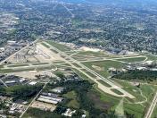
Coordinates: N42°56.43' / W78°43.83'Located 05 miles E of Buffalo, New York on 1000 acres of land. View all Airports in New York.
Surveyed Elevation is 726 feet MSL.
Operations Data
|
|
Airport Communications
| D-ATIS: | 135.35 |
|---|---|
| ASOS: | Tel. 716-587-0517 |
| BUFFALO TOWER: | 120.5 257.8 |
| BUFFALO GROUND: | 133.2 257.8 |
| BUFFALO APPROACH: | 126.15 ;053-233 126.5 ;234-052 263.125 ;053-233 317.6 ;234-052 |
| BUFFALO DEPARTURE: | 126.15 ;053-233 126.5 ;234-052 263.125 ;053-233 317.6 ;234-052 |
| IC: | 126.15 ;053-233 263.125 ;053-233 |
| CLEARANCE DELIVERY: | 124.7 257.8 |
| CLASS C: | 126.15 ;053-233 126.5 ;234-052 263.125 ;053-233 317.6 ;234-052 |
| EMERG: | 121.5 243.0 |
| PRE TAXI CLNC: | 124.7 |
| ASOS at IAG (13.6 NW): | 716-297-6984 |
| ATIS at IAG (13.8 NW): | 269.4 |
| AWOS-3PT at GVQ (25.3 E): | 127.525 585-343-6369 |
Nearby Navigation Aids
|
| ||||||||||||||||||||||||||||||||||||||||||||||||||||||||||||
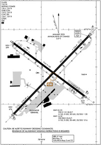
Runway 05/23
| Dimensions: | 8829 x 150 feet / 2691 x 46 meters | |
|---|---|---|
| Surface: | Asphalt / Grooved in Good Condition | |
| Weight Limits: | S-120, D-250, ST-550, DT-1120
PCR VALUE: 2110/F/B/X/T
| |
| Edge Lighting: | High Intensity | |
| Runway 05 | Runway 23 | |
| Coordinates: | N42°55.87' / W78°44.50' | N42°56.92' / W78°43.13' |
| Elevation: | 674.1 | 726.8 |
| Traffic Pattern: | Left | Left |
| Runway Heading: | 44° True | 224° True |
| Displaced Threshold: | 535 Feet | 725 Feet |
| Declared Distances: | TORA:8829 TODA:8829 ASDA:8104 LDA:7569 | TORA:8829 TODA:8829 ASDA:8294 LDA:7569 |
| Markings: | Precision Instrument in good condition. | Precision Instrument in good condition. |
| Glide Slope Indicator | P4L (3.00° Glide Path Angle) | P4R (3.00° Glide Path Angle) |
| RVR Equipment | Touchdown Midfield Rollout | Touchdown Midfield Rollout |
| Approach Lights: | MALSR 1,400 Foot Medium-intensity Approach Lighting System with runway alignment indicator lights. | ALSF2 Standard 2,400 Foot High-intensity Approach Lighting System with sequenced flashers, CATEGORY II or III Configuration. |
| Centerline Lights: | Yes | Yes |
| Obstacles: | 21 ft Building 413 ft from runway, 532 ft right of center RWY 05 APCH SLOPE 45:1 TO DSPLCD THLD. RWY 05 HAS +3 FT POLE LIGHT POLE 59 FT FM RWY END, 497 FT RIGHT. |
29 ft Tree 1155 ft from runway, 360 ft right of center |
Runway 14/32
| Dimensions: | 7161 x 150 feet / 2183 x 46 meters | |
|---|---|---|
| Surface: | Asphalt / Grooved in Good Condition | |
| Weight Limits: | S-120, D-250, ST-489, DT-1016
PCR VALUE: 900/F/D/X/T
| |
| Edge Lighting: | High Intensity | |
| Runway 14 | Runway 32 | |
| Coordinates: | N42°56.82' / W78°44.50' | N42°56.11' / W78°43.21' |
| Elevation: | 699.1 | 708.8 |
| Traffic Pattern: | Left | Left |
| Runway Heading: | 127° True | 307° True |
| Displaced Threshold: | 320 Feet | 720 Feet |
| Declared Distances: | TORA:7161 TODA:7161 ASDA:6441 LDA:6121 | TORA:7161 TODA:7161 ASDA:6841 LDA:6121 |
| Markings: | Non-Precision Instrument in good condition. | Precision Instrument in good condition. |
| Glide Slope Indicator | P4L (3.00° Glide Path Angle) | P4L (3.00° Glide Path Angle) |
| Approach Lights: | MALSR 1,400 Foot Medium-intensity Approach Lighting System with runway alignment indicator lights. | |
| REIL: | Yes | |
| Obstacles: | 31 ft Tree 608 ft from runway, 535 ft right of center RWY 14 APCH SLOPE 29:1 TO DSPLCD THLD. |
14 ft Sign 200 ft from runway, 429 ft left of center +7 FT OBSTRUCTION LIGHTED FENCE , 0 FT FM RWY END, 480 FT LEFT. |
Services Available
| Fuel: | 100LL (blue), Jet-A |
|---|---|
| Transient Storage: | Hangars,Tiedowns |
| Airframe Repair: | MAJOR |
| Engine Repair: | MAJOR |
| Bottled Oxygen: | HIGH/LOW |
| Bulk Oxygen: | HIGH/LOW |
| Other Services: | AIR FREIGHT SERVICES,AIR AMBULANCE SERVICES,AVIONICS,CARGO HANDLING SERVICES,CHARTER SERVICE,PILOT INSTRUCTION,AIRCRAFT RENTAL,AIRCRAFT SALES,ANNUAL SURVEYING |
Ownership Information
| Ownership: | Publicly owned | |
|---|---|---|
| Owner: | NIAGARA FRONTIER TRAN AUTH | |
| 181 ELLICOTT ST, PO BOX 5008 | ||
| BUFFALO, NY 14205 | ||
| 716-855-7300 | ||
| Manager: | LEE WEITZ | |
| 4200 GENESEE ST | ||
| BUFFALO, NY 14225 | ||
| (716) 630-6030 | ||
Other Remarks
- HEAVY CONCENTRATION OF GULLS; BLACKBIRDS & STARLINGS UP TO 5000 FT ON & INVOF ARPT.
- DEER ON & INVOF ARPT.
- FOR FBO SVCS CTC 131.75; FOR CARGO SVCS CTC 122.95.
- TWY A SW RUNUP AREA/HLDG BAY MKD DESIGN GROUP 3 ACFT (GENERALLY B737 A321 OR SMALLER) UNAVBL DESIGN GROUP 4 (INCL BUT NOT LTD TO B757 767).
- TWY 'K1' CLSD 2100-0800 DAILY.
- TWY P BTN APCH END RWY 14 AND TWY P2 CLSD TO ACFT WINGSPAN MORE THAN 117 FT.
Weather Minimums
Instrument Approach Procedure (IAP) Charts
Departure Procedure (DP) Charts
Nearby Airports with Instrument Procedures
| ID | Name | Heading / Distance | ||
|---|---|---|---|---|
 |
9G0 | Buffalo Airfield Airport | 172° | 4.7 |
 |
KBQR | Buffalo-Lancaster Regional Airport | 101° | 5.3 |
 |
9G3 | Akron/Jesson Field Airport | 066° | 11.9 |
 |
KIAG | Niagara Falls International Airport | 316° | 13.8 |
 |
9G6 | Pine Hill Airport | 054° | 24.4 |
 |
CYSN | St Catharines/Niagara District Airport | 308° | 24.5 |
 |
KGVQ | Genesee County Airport | 077° | 25.3 |
 |
5G0 | Le Roy Airport | 085° | 35.1 |
 |
KDKK | Chautauqua County/Dunkirk Airport | 221° | 35.9 |
 |
7G0 | Ledgedale Airpark Airport | 067° | 38.7 |
 |
KOLE | Cattaraugus County-Olean Airport | 159° | 44.9 |
 |
KROC | Frederick Douglass/Greater Rochester International Airport | 076° | 47.8 |


