Login
Register


E38
Alpine-Casparis Municipal Airport
Official FAA Data Effective 2025-12-25 0901Z
Chart Supplement

VFR Chart of E38
Sectional Charts at SkyVector.com
IFR Chart of E38
Enroute Charts at SkyVector.com
Location Information for E38
Coordinates: N30°23.05' / W103°41.01'Located 02 miles NW of Alpine, Texas on 196 acres of land. View all Airports in Texas.
Surveyed Elevation is 4514 feet MSL.
Operations Data
|
|
Airport Communications
| AWOS-3: | 119.025 Tel. 432-837-9613 |
|---|---|
| CTAF: | 122.800 |
| UNICOM: | 122.800 |
| AWOS-3PT at MRF (17.0 W): | 134.025 432-729-3364 |
| ASOS at FST (51.0 NE): | 118.525 432-336-7591 |
| AWOS-3PT at PRS (57.1 SW): | 118.0 432-229-4805 |
- APCH/DEP SVC PRVDD BY ALBUQUERQUE ARTCC (ABQ) ON FREQS 135.875/292.15 (FORT STOCKTON RCAG).
Nearby Navigation Aids
|
| ||||||||||||||||||||||||||||||||||||


Runway 01/19
| Dimensions: | 6002 x 75 feet / 1829 x 23 meters | |
|---|---|---|
| Surface: | Asphalt in Fair Condition | |
| Weight Limits: | S-12 | |
| Edge Lighting: | Medium Intensity | |
| Runway 01 | Runway 19 | |
| Coordinates: | N30°22.52' / W103°41.20' | N30°23.44' / W103°40.76' |
| Elevation: | 4514.3 | 4449.5 |
| Traffic Pattern: | Left | Left |
| Runway Heading: | 23° True | 203° True |
| Markings: | Non-Precision Instrument in fair condition. | Non-Precision Instrument in fair condition. |
| Glide Slope Indicator | P2L (3.50° Glide Path Angle) PAPI RWY 01 DOES NOT PRVD OBSTN CLNC BYD 2.0 NM FM THR. | P2L (3.00° Glide Path Angle) |
| Obstacles: | 30 ft Power Line 1340 ft from runway | 4 ft Fence 295 ft from runway |
Runway 05/23
| Dimensions: | 5018 x 60 feet / 1529 x 18 meters | |
|---|---|---|
| Surface: | Asphalt in Good Condition | |
| Weight Limits: | S-12 | |
| Edge Lighting: | Medium Intensity | |
| Runway 05 | Runway 23 | |
| Coordinates: | N30°22.94' / W103°41.47' | N30°23.33' / W103°40.63' |
| Elevation: | 4509.6 | 4447.8 |
| Traffic Pattern: | Left | Left |
| Runway Heading: | 62° True | 242° True |
| Markings: | Non-Precision Instrument in good condition. | Non-Precision Instrument in good condition. |
| Obstacles: | 10 ft Fence 500 ft from runway | 15 ft Road 537 ft from runway |
Services Available
| Fuel: | 100LL (blue), Jet-A, Jet A-1+ |
|---|---|
| Transient Storage: | NONE |
| Airframe Repair: | MAJOR |
| Engine Repair: | MAJOR |
| Bottled Oxygen: | NONE |
| Bulk Oxygen: | NONE |
| Other Services: | AIR AMBULANCE SERVICES,CHARTER SERVICE,PILOT INSTRUCTION,AIRCRAFT SALES |
Ownership Information
| Ownership: | Publicly owned | |
|---|---|---|
| Owner: | CITY OF ALPINE | |
| 100 N. 13TH STREET | ||
| ALPINE, TX 79830 | ||
| 432-837-3301 | ||
| Manager: | MEGAN ANTRIM | CITY/AMGR. |
| 100 N. 13TH STREET | ||
| ALPINE, TX 79830 | ||
| 432-837-5929 | ||
Other Remarks
- FOR CD CTC ALBUQUERQUE ARTCC AT 505-856-4861.
- SELF SVC FUEL AVBL 24 HRS.
- MIRL RWY 01/19 PRESET LOW INTST; TO INCR INTST AND TO ACTVT MIRL RWY 05/23 - CTAF.
Weather Minimums


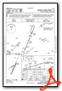
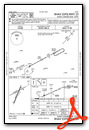
Instrument Approach Procedure (IAP) Charts
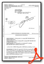
Departure Procedure Obstacles (DPO) Charts

Nearby Airports with Instrument Procedures
| ID | Name | Heading / Distance | ||
|---|---|---|---|---|
 |
KMRF | Marfa Municipal Airport | 267° | 17.3 |
|
KFST | Fort Stockton-Pecos County Airport | 051° | 51.0 |
|
KPRS | Presidio Lely International Airport | 218° | 57.1 |
|
KPEQ | Pecos Municipal Airport | 008° | 60.4 |
|
T89 | Lajitas International Airport | 180° | 66.3 |
|
KVHN | Culberson County Airport | 305° | 69.7 |
|
E01 | Roy Hurd Memorial Airport | 028° | 82.1 |
|
KINK | Winkler County Airport | 016° | 87.2 |
|
KODO | Odessa-Schlemeyer Field Airport | 035° | 113.7 |
|
KMAF | Midland International Air and Space Port Airport | 038° | 120.5 |
|
KCNM | Cavern City Air Trml Airport | 345° | 120.7 |
|
E41 | Reagan County Airport | 066° | 124.1 |
Airport Images

By: Abel Hinojos


