Login
Register


INK
Winkler County Airport
Official FAA Data Effective 2026-01-22 0901Z
Chart Supplement

VFR Chart of KINK
Sectional Charts at SkyVector.com
IFR Chart of KINK
Enroute Charts at SkyVector.com
Location Information for KINK
Coordinates: N31°46.79' / W103°12.10'Located 03 miles NW of Wink, Texas on 1000 acres of land. View all Airports in Texas.
Surveyed Elevation is 2821 feet MSL.
Operations Data
|
|
Airport Communications
| ASOS: | 118.325 Tel. 432-527-3320 |
|---|---|
| UNICOM: | 123.000 |
| CTAF: | 123.000 |
| AWOS-3PT at E01 (19.2 SE): | 118.225 432-943-2457 |
| AWOS-3 at PEQ (28.6 SW): | 118.175 432-445-3867 |
| ASOS at ODO (42.4 E): | 119.275 432-363-9719 |
- APCH/DEP SVC PRVDD BY FORT WORTH ARTCC (ZFW) ON FREQS 133.1/298.95 (MIDLAND RCAG).
Nearby Navigation Aids
|
| ||||||||||||||||||||||||||||||||||||||||||||||||||||||


Runway 13/31
| Dimensions: | 5003 x 100 feet / 1525 x 30 meters | |
|---|---|---|
| Surface: | Asphalt in Good Condition | |
| Weight Limits: | S-26, D-40 | |
| Edge Lighting: | Medium Intensity | |
| Runway 13 | Runway 31 | |
| Coordinates: | N31°46.98' / W103°12.47' | N31°46.35' / W103°11.85' |
| Elevation: | 2821.6 | 2811.8 |
| Traffic Pattern: | Left | Left |
| Runway Heading: | 140° True | 320° True |
| Markings: | Non-Precision Instrument in good condition. | Non-Precision Instrument in good condition. |
| Glide Slope Indicator | P2L (3.00° Glide Path Angle) | P2L (3.00° Glide Path Angle) |
| Obstacles: | 5 ft Brush 200 ft from runway, 244 ft right of center | 8 ft Brush 200 ft from runway, 285 ft left of center |
Runway 04/22
| Dimensions: | 3514 x 100 feet / 1071 x 30 meters | |
|---|---|---|
| Surface: | Asphalt in Good Condition | |
| Weight Limits: | S-26, D-40 | |
| Edge Lighting: | Medium Intensity | |
| Runway 04 | Runway 22 | |
| Coordinates: | N31°46.78' / W103°12.28' | N31°47.15' / W103°11.76' |
| Elevation: | 2817.6 | 2810.5 |
| Traffic Pattern: | Left | Left |
| Runway Heading: | 50° True | 230° True |
| Markings: | Basic in good condition. | Basic in good condition. |
| Obstacles: | 8 ft Brush 200 ft from runway, 39 ft right of center | 23 ft Power Line 900 ft from runway, 130 ft left of center |
Services Available
| Fuel: | 100LL (blue), Jet A+ |
|---|---|
| Transient Storage: | Hangars,Tiedowns |
| Airframe Repair: | NONE |
| Engine Repair: | NONE |
| Bottled Oxygen: | NONE |
| Bulk Oxygen: | NONE |
Ownership Information
| Ownership: | Publicly owned | |
|---|---|---|
| Owner: | WINKLER COUNTY | |
| WINKLER COUNTY COURTHOUSE, P.O. DRAWER Y | ||
| KERMIT, TX 79745 | ||
| 432-586-6658 | ||
| Manager: | CHARLES WOLF | |
| 100 E. WINKLER ST. | ||
| KERMIT, TX 79745 | ||
| 432-586-6658 | ||
Other Remarks
- THIS AIRPORT HAS BEEN SURVEYED BY THE NATIONAL GEODETIC SURVEY.
- FOR CD IF UNA TO CTC ON FSS FREQ, CTC FORT WORTH ARTCC AT 817-858-7584.
- 0LL FUEL AVBL 24 HRS SELF SERVE OR FULL SVC.
- MIRL RWYS 04/22 & 13/31 PRESET LOW INTST; TO INCR INTST - CTAF.
Weather Minimums

Instrument Approach Procedure (IAP) Charts
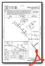


Nearby Airports with Instrument Procedures
| ID | Name | Heading / Distance | ||
|---|---|---|---|---|
 |
E01 | Roy Hurd Memorial Airport | 128° | 19.1 |
|
KPEQ | Pecos Municipal Airport | 213° | 28.6 |
|
KODO | Odessa-Schlemeyer Field Airport | 078° | 42.5 |
|
E11 | Andrews County Airport | 045° | 47.6 |
|
KMAF | Midland International Air and Space Port Airport | 078° | 52.0 |
|
KFST | Fort Stockton-Pecos County Airport | 163° | 53.8 |
|
KHOB | Lea County Regional Airport | 359° | 54.3 |
|
KMDD | Midland Airpark Airport | 074° | 58.3 |
|
KGNC | Gaines County Airport | 027° | 60.5 |
|
KCNM | Cavern City Air Trml Airport | 301° | 63.6 |
|
E06 | Lea County/Zip Franklin Memorial Airport | 351° | 71.1 |
|
E38 | Alpine-Casparis Municipal Airport | 196° | 87.2 |
Airport Images
Do you have a recent image of this airport? Upload it here!


