Login
Register


MAF
Midland International Air and Space Port Airport
Official FAA Data Effective 2025-11-27 0901Z
Chart Supplement

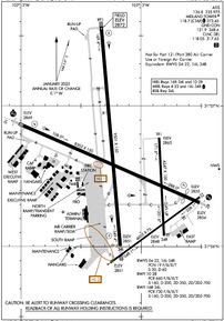
KMAF Airport Diagram
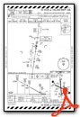
VFR Chart of KMAF
Sectional Charts at SkyVector.com
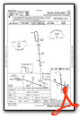
IFR Chart of KMAF
Enroute Charts at SkyVector.com
Location Information for KMAF
Coordinates: N31°56.55' / W102°12.12'Located 08 miles SW of Midland, Texas on 1600 acres of land. View all Airports in Texas.
Surveyed Elevation is 2872 feet MSL.
Operations Data
|
|
Airport Communications
| ATIS: | 126.8 235.975 |
|---|---|
| ASOS: | Tel. 432-201-2813 |
| MIDLAND TOWER: | 118.7 273.45 |
| MIDLAND GROUND: | 121.9 348.6 |
| MIDLAND APPROACH: | 121.1 ;137-240 124.6 ;241-136 256.875 ;137-240 290.4 ;241-136 |
| MIDLAND DEPARTURE: | 121.1 ;137-240 124.6 ;241-136 256.875 ;137-240 290.4 ;241-136 |
| IC: | 124.6 ;241-136 290.4 ;241-136 |
| CLEARANCE DELIVERY: | 118.05 317.65 |
| CTAF: | 118.700 |
| EMERG: | 121.5 243.0 |
| CLASS C: | 121.1 ;137-240 124.6 ;241-136 256.875 ;137-240 290.4 ;241-136 |
| UNICOM: | 122.950 |
| AWOS-3 at MDD (7.7 NE): | 118.125 432-687-4605 |
| ASOS at ODO (9.5 W): | 119.275 432-363-9719 |
| AWOS-3 at E11 (28.5 NW): | 118.2 432-524-2471 |
- APCH/DEP SVC PRVDD BY FORT WORTH ARTCC (ZFW) ON FREQS 133.1/298.95 (MIDLAND RCAG) WHEN MIDLAND APCH CLSD.
Nearby Navigation Aids
|
| ||||||||||||||||||||||||||||||||||||||||||||||||


Runway 16R/34L
180 DEG TURN PROHIBITED TO ACFT 60000 LBS OR ABV. | ||
| Dimensions: | 9501 x 150 feet / 2896 x 46 meters | |
|---|---|---|
| Surface: | Asphalt / Grooved in Good Condition | |
| Weight Limits: | S-160, D-200, ST-350, DT-700
PCR VALUE: 730/F/B/X/T
| |
| Edge Lighting: | High Intensity | |
| Runway 16R | Runway 34L | |
| Coordinates: | N31°57.56' / W102°12.33' | N31°56.00' / W102°12.17' |
| Elevation: | 2872.1 | 2851.0 |
| Traffic Pattern: | Left | Left |
| Runway Heading: | 175° True | 355° True |
| Declared Distances: | TORA:9501 TODA:9501 ASDA:9501 LDA:9501 | TORA:9501 TODA:9501 ASDA:9501 LDA:9501 |
| Markings: | Precision Instrument in good condition. | Precision Instrument in good condition. |
| Glide Slope Indicator | P4L (3.00° Glide Path Angle) | P4L (3.00° Glide Path Angle) |
| REIL: | Yes | |
| Obstacles: | 28 ft Pole 1550 ft from runway, 300 ft left of center | |
Runway 10/28
180 DEG TURN PROHIBITED TO ACFT 60000 LBS OR ABV. | ||
| Dimensions: | 8302 x 150 feet / 2530 x 46 meters EAST 692 FT CLSD TO ACFT OVER 60000 LBS. | |
|---|---|---|
| Surface: | Asphalt / Grooved in Good Condition | |
| Weight Limits: | S-160, D-200, ST-350, DT-700
PCR VALUE: 660/F/B/X/T
| |
| Edge Lighting: | High Intensity | |
| Runway 10 | Runway 28 | |
| Coordinates: | N31°56.86' / W102°12.98' | N31°56.31' / W102°11.51' |
| Elevation: | 2869.3 | 2854.0 |
| Traffic Pattern: | Left | Left |
| Runway Heading: | 114° True | 294° True |
| Displaced Threshold: | 691 Feet | |
| Declared Distances: | TORA:8302 TODA:8302 ASDA:8177 LDA:8177 | TORA:8302 TODA:8302 ASDA:8302 LDA:7610 |
| Markings: | Precision Instrument in good condition. | Precision Instrument in good condition. |
| Glide Slope Indicator | P4L (3.00° Glide Path Angle) | P4R (3.00° Glide Path Angle) |
| RVR Equipment | Touchdown | Rollout |
| Approach Lights: | MALSR 1,400 Foot Medium-intensity Approach Lighting System with runway alignment indicator lights. | MALS 1,400 Foot Medium-intensity Approach Lighting System. |
Runway 04/22
RWY 04/22 NOT AVBL FOR PART 121/PART 380 OPS WITH SKED PAX CARRYING OPS MORE THAN 9 PAX SEATS AND NON-SKED PAX CARRYING OPS MORE THAN 30 PAX SEATS. | ||
| Dimensions: | 4605 x 75 feet / 1404 x 23 meters | |
|---|---|---|
| Surface: | Asphalt in Good Condition | |
| Weight Limits: | 19 /F/B/X/T, S-30, D-60 | |
| Edge Lighting: | Medium Intensity | |
| Runway 04 | Runway 22 | |
| Coordinates: | N31°55.90' / W102°12.23' | N31°56.35' / W102°11.51' |
| Elevation: | 2851.3 | 2854.9 |
| Traffic Pattern: | Left | Left |
| Runway Heading: | 54° True | 234° True |
| Declared Distances: | TORA:4605 TODA:4605 ASDA:4605 LDA:4605 | TORA:4605 TODA:4605 ASDA:4605 LDA:4605 |
| Markings: | Non-Precision Instrument in good condition. | Non-Precision Instrument in good condition. |
| Obstacles: | 57 ft Pole 2688 ft from runway, 390 ft right of center | 23 ft Road 1333 ft from runway, 9 ft left of center |
Runway 16L/34R
RWY 16L/34R NOT AVBL FOR PART 121/PART 380 OPS WITH SKED PAX CARRYING OPS MORE THAN 9 PAX SEATS AND NON-SKED PAX CARRYING OPS MORE THAN 30 PAX SEATS. | ||
| Dimensions: | 4247 x 100 feet / 1294 x 30 meters | |
|---|---|---|
| Surface: | Asphalt in Good Condition | |
| Weight Limits: | 19 /F/B/X/T, S-30, D-60 | |
| Edge Lighting: | Medium Intensity | |
| Runway 16L | Runway 34R | |
| Coordinates: | N31°56.77' / W102°11.85' | N31°56.07' / W102°11.81' |
| Elevation: | 2864.6 | 2847.9 |
| Traffic Pattern: | Left | Left |
| Runway Heading: | 177° True | 357° True |
| Declared Distances: | TORA:4247 TODA:4247 ASDA:4247 LDA:4247 | TORA:4247 TODA:4247 ASDA:4247 LDA:4247 |
| Markings: | Basic in good condition. | Basic in good condition. |
| Obstacles: | 7 ft Fence 375 ft from runway | 13 ft Road 390 ft from runway, 250 ft right of center |
Services Available
| Fuel: | 100LL (blue), Jet-A, Jet A-1 |
|---|---|
| Transient Storage: | Hangars,Tiedowns |
| Airframe Repair: | MAJOR |
| Engine Repair: | MAJOR |
| Bottled Oxygen: | LOW |
| Bulk Oxygen: | LOW |
| Other Services: | AIR FREIGHT SERVICES,AIR AMBULANCE SERVICES,AVIONICS,CARGO HANDLING SERVICES,CHARTER SERVICE,PILOT INSTRUCTION,AIRCRAFT RENTAL,AIRCRAFT SALES |
Ownership Information
| Ownership: | Publicly owned | |
|---|---|---|
| Owner: | CITY OF MIDLAND | |
| PO BOX 1152 | ||
| MIDLAND, TX 79702 | ||
| 432-685-7100 | ||
| Manager: | JUSTINE RUFF | |
| PO BOX 60305 | ||
| MIDLAND, TX 79711 | ||
| 432-560-2200 | ||
Other Remarks
- THIS AIRPORT HAS BEEN SURVEYED BY THE NATIONAL GEODETIC SURVEY.
- OPRS ON NON PAVED SFC ARE PROHIBITED WO 24 HR PPR.
- RWYS 04/22 & 16L/34R CLSD TO ACFT OVER 60000 LBS.
- TWYS B & F NORTH RWY 10/28 CLSD TO ACFT OVER 60000 LBS.
- BIRD ACTIVITY ON & INVOF ARPT.
- NMRS OIL RIGS INVOF ARPT AT OR BLW 200 FT AGL.
- ALL RUNUP PADS ARE LTD USAGE TO ACFT 60000 LBS OR BLW.
- FOR CD IF UNA TO CTC ON FSS FREQ, CTC FORT WORTH ARTCC AT 817-858-7584.
- ATC CTL. WHEN ATCT CLSD HIRL RWYS 10/28 & 16R/34L PRESET ON LOW INTST. WHEN ATCT CLSD ACTVT MALSR RWY 10; MALS RWY 28; MIRL RWYS 04/22 & 16L/34R - CTAF.
Weather Minimums

Instrument Approach Procedure (IAP) Charts


Nearby Airports with Instrument Procedures
| ID | Name | Heading / Distance | ||
|---|---|---|---|---|
 |
KMDD | Midland Airpark Airport | 042° | 7.6 |
|
KODO | Odessa-Schlemeyer Field Airport | 262° | 9.5 |
|
E11 | Andrews County Airport | 324° | 28.6 |
|
KBPG | Big Spring/Mc Mahon-Wrinkle Airport | 064° | 38.3 |
|
E01 | Roy Hurd Memorial Airport | 239° | 42.1 |
|
KGNC | Gaines County Airport | 332° | 49.5 |
|
KLUV | Lamesa Municipal Airport | 016° | 50.8 |
|
KINK | Winkler County Airport | 259° | 52.0 |
|
E41 | Reagan County Airport | 139° | 58.1 |
|
KHOB | Lea County Regional Airport | 311° | 68.2 |
|
KFST | Fort Stockton-Pecos County Airport | 210° | 71.5 |
|
KBFE | Terry County Airport | 000° | 73.7 |
Airport Images
Do you have a recent image of this airport? Upload it here!


