Login
Register


EAG
Eagle Grove Municipal Airport
Official FAA Data Effective 2025-12-25 0901Z
Chart Supplement

VFR Chart of KEAG
Sectional Charts at SkyVector.com
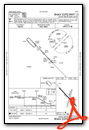
IFR Chart of KEAG
Enroute Charts at SkyVector.com
Location Information for KEAG
Coordinates: N42°42.60' / W93°54.97'Located 03 miles N of Eagle Grove, Iowa on 150 acres of land. View all Airports in Iowa.
Surveyed Elevation is 1132 feet MSL.
Operations Data
|
|
Airport Communications
| CTAF: | 122.800 |
|---|---|
| UNICOM: | 122.800 |
| AWOS-3 at CAV (7.2 E): | 126.575 515-532-3515 |
| AWOS-3PT at FOD (15.5 SW): | 118.775 515-955-5490 |
| AWOS-3 at EBS (16.5 S): | 127.825 515-832-2794 |
- APCH/DEP SVC PRVDD BY MINNEAPOLIS ARTCC ON FREQS 134.0/288.3 (FORT DODGE RCAG).
Nearby Navigation Aids
|
| ||||||||||||||||||||||||||||||||||||||||||||||||||||||||||||


Runway 13/31
| Dimensions: | 3500 x 60 feet / 1067 x 18 meters | |
|---|---|---|
| Surface: | Concrete in Fair Condition | |
| Edge Lighting: | Medium Intensity | |
| Runway 13 | Runway 31 | |
| Coordinates: | N42°42.82' / W93°55.26' | N42°42.40' / W93°54.72' |
| Elevation: | 1130.9 | 1128.6 |
| Traffic Pattern: | Left | Left |
| Runway Heading: | 136° True | 316° True |
| Displaced Threshold: | 119 Feet | |
| Markings: | Non-Precision Instrument in fair condition. | Non-Precision Instrument in fair condition. |
| REIL: | Yes REIL OTS INDEFLY. | Yes REIL OTS INDEFLY. |
| Obstacles: | 15 ft Road 200 ft from runway, 120 ft right of center DSPLCD THR ALLOWS A 20:1 CLNC OVER ROAD. +15 ROAD 184' FM THR 120' R. |
46 ft Tree 1429 ft from runway, 19 ft left of center |
Runway 01/19
CLSD NOV-APR. | ||
| Dimensions: | 2389 x 120 feet / 728 x 37 meters | |
|---|---|---|
| Surface: | Turf in Fair Condition | |
| Runway 01 | Runway 19 | |
| Coordinates: | N42°42.39' / W93°55.00' | N42°42.77' / W93°54.85' |
| Elevation: | 1128.8 | 1128.0 |
| Traffic Pattern: | Left | Left |
| Runway Heading: | 16° True | 196° True |
Services Available
| Fuel: | 100LL (blue) |
|---|---|
| Transient Storage: | Hangars,Tiedowns |
| Airframe Repair: | NONE |
| Engine Repair: | NONE |
| Bottled Oxygen: | NONE |
| Bulk Oxygen: | NONE |
Ownership Information
| Ownership: | Publicly owned | |
|---|---|---|
| Owner: | CITY OF EAGLE GROVE | DON GARRETT ARPT CMSN CHMN; PHONE 515-448-4073. |
| 210 EAST BROADWAY | ||
| EAGLE GROVE, IA 50533 | ||
| 515-448-4343 | ||
| Manager: | BRYCE DAVIS | |
| 2355 HWY 17 | ||
| EAGLE GROVE, IA 50533 | ||
| 515-851-5826 | ||
Other Remarks
- FOR CD CTC MINNEAPOLIS ARTCC AT 651-463-5588.
- 01/19 MKD WITH YELLOW CONES.
- ACTVT MIRL RY 13/31 & REIL RYS 13 & 31 - CTAF.
Weather Minimums

Instrument Approach Procedure (IAP) Charts

Nearby Airports with Instrument Procedures
| ID | Name | Heading / Distance | ||
|---|---|---|---|---|
 |
KCAV | Clarion Municipal Airport | 075° | 7.2 |
|
KFOD | Fort Dodge Regional Airport | 232° | 15.5 |
|
KEBS | Webster City Municipal Airport | 172° | 16.5 |
|
KAXA | Algona Municipal Airport | 324° | 27.1 |
|
KHPT | Hampton Municipal Airport | 088° | 30.5 |
|
KIFA | Iowa Falls Municipal Airport | 116° | 32.0 |
|
KPOH | Pocahontas Municipal Airport | 273° | 32.4 |
|
KFXY | Forest City Municipal/Trimble Field Airport | 022° | 34.0 |
|
KMCW | Mason City Municipal Airport | 043° | 37.2 |
|
KBNW | Boone Municipal Airport | 175° | 39.7 |
|
KEGQ | Emmetsburg Municipal Airport | 304° | 42.0 |
|
KAMW | Ames Municipal Airport | 162° | 45.0 |
Airport Images
Do you have a recent image of this airport? Upload it here!


