Login
Register


FXY
Forest City Municipal/Trimble Field Airport
Official FAA Data Effective 2025-11-27 0901Z
Chart Supplement

VFR Chart of KFXY
Sectional Charts at SkyVector.com
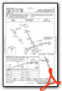
IFR Chart of KFXY
Enroute Charts at SkyVector.com
Location Information for KFXY
Coordinates: N43°14.09' / W93°37.45'Located 02 miles S of Forest City, Iowa on 250 acres of land. View all Airports in Iowa.
Surveyed Elevation is 1229 feet MSL.
Operations Data
|
|
Airport Communications
| AWOS-3: | 123.925 Tel. 641-581-2347 |
|---|---|
| UNICOM: | 122.800 |
| CTAF: | 122.800 |
| ASOS at MCW (13.6 E): | 120.300 641-255-0381 |
| AWOS-3PT at AEL (29.1 NE): | 119.575 507-377-1583 |
| AWOS-3 at AXA (29.9 W): | 118.475 515-295-9634 |
- COMMUNICATIONS PRVDD BY FORT DODGE RADIO ON FREQ 122.6 (MASON CITY RCO).
- APCH/DEP SVC PRVDD BY MINNEAPOLIS ARTCC ON FREQS 127.3/257.675 (MASON CITY RCAG).
Nearby Navigation Aids
|
| ||||||||||||||||||||||||||||||||||||||||||||||||||||||||||||


Runway 15/33
| Dimensions: | 5796 x 100 feet / 1767 x 30 meters | |
|---|---|---|
| Surface: | Asphalt in Good Condition | |
| Weight Limits: | S-30 | |
| Edge Lighting: | Medium Intensity | |
| Runway 15 | Runway 33 | |
| Coordinates: | N43°14.44' / W93°37.62' | N43°13.57' / W93°37.06' |
| Elevation: | 1206.7 | 1202.8 |
| Traffic Pattern: | Left | Left |
| Runway Heading: | 155° True | 335° True |
| Displaced Threshold: | 600 Feet 34:1 TO DTHR. |
|
| Markings: | Non-Precision Instrument in good condition. | Non-Precision Instrument in good condition. |
| Glide Slope Indicator | P2L (3.00° Glide Path Angle) | P2L (3.00° Glide Path Angle) |
| REIL: | Yes | Yes |
| Obstacles: | 39 ft Trees 750 ft from runway, 10 ft left of center | 5 ft Fence 315 ft from runway |
Runway 09/27
| Dimensions: | 2707 x 60 feet / 825 x 18 meters | |
|---|---|---|
| Surface: | Asphalt in Good Condition | |
| Weight Limits: | 4 /F/C/X/U, S-12 | |
| Edge Lighting: | Medium Intensity | |
| Runway 09 | Runway 27 | |
| Coordinates: | N43°14.27' / W93°37.98' | N43°14.24' / W93°37.37' |
| Elevation: | 1229.2 | 1203.4 |
| Traffic Pattern: | Left | |
| Runway Heading: | 95° True | 275° True |
| Markings: | Basic in fair condition. | Basic in fair condition. |
| Obstacles: | 34 ft Tree 645 ft from runway, 121 ft left of center | 11 ft Tree 231 ft from runway, 49 ft right of center |
Services Available
| Fuel: | 100LL (blue) |
|---|---|
| Transient Storage: | Tiedowns |
| Airframe Repair: | MAJOR |
| Engine Repair: | MAJOR |
| Bottled Oxygen: | NONE |
| Bulk Oxygen: | NONE |
| Other Services: | PILOT INSTRUCTION,AIRCRAFT RENTAL,AIRCRAFT SALES |
Ownership Information
| Ownership: | Publicly owned | |
|---|---|---|
| Owner: | CITY OF FOREST CITY | |
| 305 N. CLARK | ||
| FOREST CITY, IA 50436 | ||
| 641-585-3574 | ||
| Manager: | R. TRIMBLE | |
| MUNICIPAL ARPT, 1842 330TH ST | ||
| FOREST CITY, IA 50436 | ||
| 641-581-2880 | 641-585-2166. | |
Other Remarks
- FOR CD CTC MINNEAPOLIS ARTCC AT 651-463-5588.
- ACTVT REIL RWY 15 & 33; PAPI RWY 15 & 33; MIRL RWY 09/27 & 15/33 - CTAF.
Weather Minimums


Instrument Approach Procedure (IAP) Charts


Nearby Airports with Instrument Procedures
| ID | Name | Heading / Distance | ||
|---|---|---|---|---|
 |
KMCW | Mason City Municipal Airport | 109° | 13.7 |
|
KAEL | Albert Lea Municipal Airport | 022° | 29.0 |
|
KSBU | Blue Earth Municipal Airport | 316° | 29.8 |
|
KAXA | Algona Municipal Airport | 251° | 30.0 |
|
KCAV | Clarion Municipal Airport | 191° | 30.2 |
|
KEAG | Eagle Grove Municipal Airport | 202° | 34.0 |
|
KHPT | Hampton Municipal Airport | 150° | 35.3 |
|
KAUM | Austin Municipal Airport | 049° | 39.6 |
|
KFRM | Fairmont Municipal Airport | 305° | 42.4 |
|
KCCY | Northeast Iowa Regional Airport | 101° | 45.6 |
|
KEGQ | Emmetsburg Municipal Airport | 260° | 48.1 |
|
KFOD | Fort Dodge Regional Airport | 211° | 48.0 |
Airport Images

By: anonymous


