Login
Register


EPH
Ephrata Municipal Airport
Official FAA Data Effective 2026-02-19 0901Z
Chart Supplement

VFR Chart of KEPH
Sectional Charts at SkyVector.com
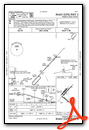
IFR Chart of KEPH
Enroute Charts at SkyVector.com
Location Information for KEPH
Coordinates: N47°18.48' / W119°31.01'Located 02 miles SE of Ephrata, Washington on 2300 acres of land. View all Airports in Washington.
Surveyed Elevation is 1276 feet MSL.
Operations Data
|
|
Airport Communications
| ASOS: | 135.775 Tel. 509-754-3761 |
|---|---|
| GRANT COUNTY APPROACH: | 126.4 379.95 |
| GRANT COUNTY DEPARTURE: | 126.4 379.95 |
| IC: | 126.4 379.95 |
| UNICOM: | 122.800 |
| CTAF: | 122.800 |
| ASOS at MWH (10.0 SE): | 119.05 509-762-5082 |
| ATIS at MWH (10.0 SE): | 119.05 |
| ASOS at EAT (28.3 W): | 119.925 509-886-4226 |
- APCH/DEP CTL SVC PRVDD BY SEATTLE ARTCC (ZSE) ON FREQS 126.1/291.6 (MARLIN RCAG) WHEN GRANT COUNTY APCH CTL (MWH)CLSD.
Nearby Navigation Aids
|
| ||||||||||||||||||||||||||||||||||||||||||


Runway 03/21
| Dimensions: | 5500 x 75 feet / 1676 x 23 meters | |
|---|---|---|
| Surface: | Asphalt in Good Condition | |
| Weight Limits: | S-30, D-60 | |
| Edge Lighting: | Medium Intensity | |
| Runway 03 | Runway 21 | |
| Coordinates: | N47°18.35' / W119°31.31' | N47°19.02' / W119°30.41' |
| Elevation: | 1261.4 | 1275.5 |
| Traffic Pattern: | Right | Left |
| Runway Heading: | 43° True | 223° True |
| Markings: | Non-Precision Instrument in good condition. | Non-Precision Instrument in good condition. |
| Glide Slope Indicator | P4L (3.00° Glide Path Angle) | P4L (3.00° Glide Path Angle) |
| REIL: | Yes | Yes |
| Obstacles: | 58 ft Ground 2450 ft from runway, 550 ft left of center | |
Runway 11/29
| Dimensions: | 3843 x 60 feet / 1171 x 18 meters | |
|---|---|---|
| Surface: | Asphalt in Good Condition | |
| Weight Limits: | S-12 | |
| Edge Lighting: | Medium Intensity | |
| Runway 11 | Runway 29 | |
| Coordinates: | N47°18.28' / W119°31.44' | N47°17.89' / W119°30.70' |
| Elevation: | 1261.3 | 1257.3 |
| Traffic Pattern: | Left | Left |
| Runway Heading: | 128° True | 308° True |
| Markings: | Basic in good condition. | Basic in good condition. |
| Glide Slope Indicator | P2L (3.00° Glide Path Angle) | |
| REIL: | Yes | Yes |
| Obstacles: | 52 ft Ground 1666 ft from runway, 293 ft left of center | |
Runway 04/22
RWY 04/22 GLDS USE 1 APR TO 1 NOV. | ||
| Dimensions: | 3467 x 150 feet / 1057 x 46 meters | |
|---|---|---|
| Surface: | Asphalt in Fair Condition | |
| Weight Limits: | S-12 | |
| Runway 04 | Runway 22 | |
| Coordinates: | N47°18.40' / W119°31.48' | N47°18.82' / W119°30.91' |
| Elevation: | 1260.9 | 1261.5 |
| Traffic Pattern: | Right | |
| Runway Heading: | 42° True | 222° True |
| Markings: | None in fair condition. | None in fair condition. |
Services Available
| Fuel: | 100LL (blue), Jet-A, Jet A+ |
|---|---|
| Transient Storage: | Hangars,Tiedowns |
| Airframe Repair: | MINOR |
| Engine Repair: | MINOR |
| Bottled Oxygen: | NONE |
| Bulk Oxygen: | NOT AVAILABLE |
| Other Services: | CROP DUSTING SERVICES,GLIDER SERVICE |
Ownership Information
| Ownership: | Publicly owned | |
|---|---|---|
| Owner: | PORT DIST NO 9 GRANT CO | |
| PORT OF EPHRATA PO BOX 1089 | ||
| EPHRATA, WA 98823 | ||
| 509-754-3508 | ||
| Manager: | DAVID LANMAN | |
| PO BOX 1089 | ||
| EPHRATA, WA 98823 | ||
| 509-754-3508 | ||
Other Remarks
- BE ALERT AEROBATIC ACFT ACTIVITY OVER CENTER OF AIRPORT.
- (E81) REFLECTORS ON PORTIONS OF TWYS.
- CONDS NOT MNT MON-FRI 1600-0700, CONDS NOT MNT SAT-SUN & HOLS 1600-0700.
- FOR CD IF UNA TO CTC ON FSS FREQ, CTC GRANT COUNTY APCH AT 509-762-2842. WHEN APCH CLSD CTC SEATTLE ARTCC AT 253-351-3694.
- 0LL FUEL 24 HR CREDIT CARD SVC AVBL.
- JET-A AVBL SEVEN DAYS A WEEK 1500Z-2300Z.
- JET-A W/ ADDITIVE AVBL SEVEN DAYS A WEEK 1500Z-2300Z
- ACTVT REIL RWYS 3, 11, 21 & 29; MIRL RWY 03/21 & MIRL RWY 11/29 - CTAF. PAPI RWY 29, RWY 03 & RWY 21 OPR CONSLY.
- UNICOM MNTD INTMTLY.
Weather Minimums


Instrument Approach Procedure (IAP) Charts


Nearby Airports with Instrument Procedures
| ID | Name | Heading / Distance | ||
|---|---|---|---|---|
 |
KMWH | Grant County International Airport | 126° | 10.0 |
|
KEAT | Pangborn Memorial Airport | 281° | 28.7 |
|
2S8 | Wilbur Airport | 049° | 41.3 |
|
KELN | Bowers Field Airport | 248° | 44.6 |
|
KRLD | Richland Airport | 171° | 60.8 |
|
KYKM | Yakima Air Trml/Mcallister Field Airport | 223° | 61.3 |
|
KPSC | Tri-Cities Airport | 165° | 64.7 |
|
KOMK | Omak Airport | 359° | 69.4 |
|
KSKA | Fairchild AFB Airport | 075° | 78.0 |
|
KGEG | Spokane International Airport | 076° | 82.8 |
|
KALW | Walla Walla Regional Airport | 144° | 89.0 |
|
KHRI | Hermiston Municipal Airport | 173° | 89.5 |
Airport Images
Do you have a recent image of this airport? Upload it here!


