Login
Register


ALW
Walla Walla Regional Airport
Official FAA Data Effective 2026-02-19 0901Z
Chart Supplement

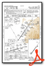
KALW Airport Diagram

VFR Chart of KALW
Sectional Charts at SkyVector.com
IFR Chart of KALW
Enroute Charts at SkyVector.com
Location Information for KALW
Coordinates: N46°5.55' / W118°17.04'Located 03 miles NE of Walla Walla, Washington on 3000 acres of land. View all Airports in Washington.
Surveyed Elevation is 1194 feet MSL.
Operations Data
|
|
Airport Communications
| ASOS: | 135.875 Tel. 509-525-3014 |
|---|---|
| WALLA WALLA TOWER: | 118.5 289.4 |
| WALLA WALLA GROUND: | 121.6 289.4 |
| SPOKANE APPROACH: | 133.15 379.15 |
| SPOKANE DEPARTURE: | 133.15 379.15 |
| UNICOM: | 122.950 |
| CTAF: | 118.500 |
| ASOS at PDT (33.3 SW): | 118.325 458-212-2168 |
| ATIS at PSC (36.2 W): | 125.65 |
| ASOS at PSC (36.3 W): | 509-547-7379 |
- FREQ 121.5 NOT AVBL.
- APCH/DEP CTL SVC PROVDD BY SEATTLE ARTCC (ZSE) ON 132.6/269.35 (YAKIMA RCAG), WHEN GEG APCH CLSD.
Nearby Navigation Aids
|
| ||||||||||||||||||||||||||||||||||||||||||||||||


Runway 02/20
| Dimensions: | 6527 x 150 feet / 1989 x 46 meters | |
|---|---|---|
| Surface: | Concrete / Grooved in Good Condition | |
| Weight Limits: | S-84, D-107, ST-164
PCR VALUE: 340/F/D/X/T
| |
| Edge Lighting: | High Intensity | |
| Runway 02 | Runway 20 | |
| Coordinates: | N46°5.12' / W118°17.50' | N46°5.99' / W118°16.59' |
| Elevation: | 1153.9 | 1194.4 |
| Traffic Pattern: | Left | Left |
| Runway Heading: | 36° True | 216° True |
| Declared Distances: | TORA:6527 TODA:6527 ASDA:6527 LDA:6527 | TORA:6527 TODA:6527 ASDA:6527 LDA:6527 |
| Markings: | Non-Precision Instrument in good condition. | Precision Instrument in good condition. |
| Glide Slope Indicator | P4L (3.00° Glide Path Angle) | P4L (3.00° Glide Path Angle) |
| RVR Equipment | Rollout | Touchdown |
| Approach Lights: | MALSR 1,400 Foot Medium-intensity Approach Lighting System with runway alignment indicator lights. | |
| REIL: | Yes | |
Services Available
| Fuel: | 100LL (blue), Jet-A |
|---|---|
| Transient Storage: | Hangars,Tiedowns |
| Airframe Repair: | MAJOR |
| Engine Repair: | MAJOR |
| Bottled Oxygen: | NOT AVAILABLE |
| Bulk Oxygen: | LOW |
| Other Services: | AIR FREIGHT SERVICES,CROP DUSTING SERVICES,AIR AMBULANCE SERVICES,CARGO HANDLING SERVICES,CHARTER SERVICE,PILOT INSTRUCTION,AIRCRAFT RENTAL,AIRCRAFT SALES |
Ownership Information
| Ownership: | Publicly owned | |
|---|---|---|
| Owner: | PORT OF WALLA WALLA | |
| 45 TERMINAL LOOP RD., SUITE 210 | ||
| WALLA WALLA, WA 99362 | ||
| 509-525-3100 | ||
| Manager: | JENNIFER SKOGLUND | |
| 45 TERMINAL LOOP RD., SUITE 210 | ||
| WALLA WALLA, WA 99362 | ||
| 509-525-3100 | ||
Other Remarks
- SFC CONDS UNMON 0000-0300.
- TWY A,A1,A2,A3,A4,A5 OPEN TO AIR CARRIERS.
- 24 HR FUEL SVC CALL 509-540-1081.
- PTN OF CORNER AT TWY A & TWY A1 NOT VSB BY TWR.
- FOR CD WHEN ALW ATC IS CLSD CTC SPOKANE APCH AT 509-742-2525. WHEN APCH CLSD CTC SEATTLE ARTCC AT 253-351-3694
- CTC AMGR 509-525-3100 FOR ARNGMT FOR RAMP PRKG OF 175,000 LB MTOW
- 0LL SELF SVC CREDIT CARD FUELING FACILITY LCTD 600 FT N OF ATCT.
- WHEN ATCT CLSD ACTVT MALSR RY 20, REIL RY 02 & HIRL RY 02/20 - CTAF.
Weather Minimums


Instrument Approach Procedure (IAP) Charts


Departure Procedure (DP) Charts

Nearby Airports with Instrument Procedures
| ID | Name | Heading / Distance | ||
|---|---|---|---|---|
 |
KPDT | Eastern Oregon Regional At Pendleton Airport | 224° | 33.4 |
|
KPSC | Tri-Cities Airport | 286° | 36.3 |
|
KHRI | Hermiston Municipal Airport | 249° | 43.8 |
|
KRLD | Richland Airport | 287° | 44.4 |
|
KLGD | La Grande/Union County Airport | 166° | 49.6 |
|
KLWS | Lewiston/Nez Perce County Airport | 071° | 55.5 |
|
KJSY | Joseph State Airport | 135° | 61.7 |
|
KPUW | Pullman/Moscow Regional Airport | 050° | 62.3 |
|
9S9 | Lexington Airport | 237° | 70.4 |
|
KBKE | Baker City Municipal Airport | 164° | 77.9 |
|
KMWH | Grant County International Airport | 327° | 79.5 |
|
KEPH | Ephrata Municipal Airport | 325° | 89.0 |
Airport Images

By: NW Aeronaut


