Login
Register


PSC
Tri-Cities Airport
Official FAA Data Effective 2026-02-19 0901Z
Chart Supplement

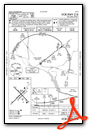
KPSC Airport Diagram

VFR Chart of KPSC
Sectional Charts at SkyVector.com
IFR Chart of KPSC
Enroute Charts at SkyVector.com
Location Information for KPSC
Coordinates: N46°15.90' / W119°7.16'Located 02 miles NW of Pasco, Washington on 2235 acres of land. View all Airports in Washington.
Surveyed Elevation is 410 feet MSL.
Operations Data
|
|
Airport Communications
| ATIS: | 125.65 |
|---|---|
| ASOS: | Tel. 509-547-7379 |
| TRI-CITIES TOWER: | 135.3 285.55 |
| TRI-CITIES GROUND: | 121.8 |
| SPOKANE APPROACH: | 128.75 ;NORTH & WEST 133.15 ;EAST & SOUTH 377.2 ;NORTH & WEST 379.15 ;NORTH & WEST |
| SPOKANE DEPARTURE: | 128.75 ;NORTH & WEST 133.15 ;EAST & SOUTH 377.2 ;NORTH & WEST 379.15 ;NORTH & WEST |
| IC: | 128.75 ;NORTH & WEST 377.2 ;NORTH & WEST |
| CLEARANCE DELIVERY: | 120.0 |
| UNICOM: | 122.950 |
| CTAF: | 135.300 |
| AWOS-3PT at RLD (8.2 W): | 132.675 509-375-4247 |
| ASOS at HRI (26.9 S): | 135.225 541-567-8580 |
| AWOS-1 at S40 (28.3 W): | 121.125 509-786-8889 |
- COMMUNICATIONS PRVDD BY SEATTLE RADIO ON FREQ 122.4 (JUMP-OFF-JOE RCO).
- APCH/DEP CTL SVC PROVDD BY SEATTLE ARTCC (ZSE) ON 132.6/269.35 (YAKIMA RCAG), WHEN GEG APCH CLSD.
Nearby Navigation Aids
|
| ||||||||||||||||||||||||||||||||||||||||||||||||||||||


Runway 03L/21R
| Dimensions: | 7707 x 150 feet / 2349 x 46 meters | |
|---|---|---|
| Surface: | Asphalt / Grooved in Good Condition | |
| Weight Limits: | S-150, D-200, ST-400
PCR VALUE: 384/F/B/X/U
| |
| Edge Lighting: | High Intensity | |
| Runway 03L | Runway 21R | |
| Coordinates: | N46°15.36' / W119°8.01' | N46°16.24' / W119°6.70' |
| Elevation: | 409.9 | 401.3 |
| Traffic Pattern: | Left | Right |
| Runway Heading: | 45° True | 225° True |
| Displaced Threshold: | 597 Feet | |
| Declared Distances: | TORA:7707 TODA:7707 ASDA:7707 LDA:7707 | TORA:7707 TODA:7707 ASDA:7707 LDA:7110 |
| Markings: | Non-Precision Instrument in good condition. | Precision Instrument in good condition. |
| Glide Slope Indicator | P4L (3.00° Glide Path Angle) | P4L (3.00° Glide Path Angle) |
| RVR Equipment | Rollout | Touchdown |
| Approach Lights: | MALSR 1,400 Foot Medium-intensity Approach Lighting System with runway alignment indicator lights. | |
| REIL: | Yes | |
| Obstacles: | 61 ft Tree 2550 ft from runway, 750 ft right of center | 49 ft Pole 1900 ft from runway, 450 ft left of center 81 FT TWR 3036 FT & 900 FT LEFT; 37:1 SLOPE TO DTHR. |
Runway 12/30
| Dimensions: | 7704 x 150 feet / 2348 x 46 meters | |
|---|---|---|
| Surface: | Asphalt / Grooved in Good Condition | |
| Weight Limits: | S-150, D-200, ST-400
PCR VALUE: 466/F/B/X/T
| |
| Edge Lighting: | Medium Intensity | |
| Runway 12 | Runway 30 | |
| Coordinates: | N46°16.45' / W119°7.74' | N46°15.54' / W119°6.46' |
| Elevation: | 394.1 | 402.0 |
| Traffic Pattern: | Left | Left |
| Runway Heading: | 135° True | 315° True |
| Declared Distances: | TORA:7704 TODA:7704 ASDA:7704 LDA:7704 | TORA:7704 TODA:7704 ASDA:7704 LDA:7704 |
| Markings: | Non-Precision Instrument in good condition. | Non-Precision Instrument in good condition. |
| Glide Slope Indicator | P4L (3.00° Glide Path Angle) | P4L (3.00° Glide Path Angle) |
| Approach Lights: | MALSF 1,400 Foot Medium-intensity Approach Lighting System with sequenced flashers. | |
| REIL: | Yes | |
| Obstacles: | 30 ft Tree 1312 ft from runway, 177 ft left of center | |
Runway 03R/21L
RWY 03R/21L NOT AVBL FOR PART 121/PART 380 OPS WITH SKED PAX CARRYING OPS MORE THAN 9 PAX SEATS AND NON-SKED PAX CARRYING OPS MORE THAN 30 PAX SEATS. NOT AVBL AS MOVEMENT AREA. | ||
| Dimensions: | 4423 x 75 feet / 1348 x 23 meters | |
|---|---|---|
| Surface: | Asphalt in Fair Condition RY 03R/21L SFC CRACKING. | |
| Weight Limits: | 13 /F/B/X/T, S-52, D-85, ST-108, DT-150 | |
| Runway 03R | Runway 21L | |
| Coordinates: | N46°15.64' / W119°7.32' | N46°16.15' / W119°6.57' |
| Elevation: | 402.9 | 403.8 |
| Traffic Pattern: | Right | Left |
| Runway Heading: | 45° True | 225° True |
| Declared Distances: | TORA:4423 TODA:4423 ASDA:4423 LDA:4423 | TORA:4423 TODA:4423 ASDA:4423 LDA:4423 |
| Markings: | Basic in good condition. | Basic in good condition. |
| Obstacles: | 79 ft Tower 2445 ft from runway, 77 ft left of center | |
Services Available
| Fuel: | 100LL (blue), Jet A-1+ |
|---|---|
| Transient Storage: | Hangars,Tiedowns |
| Airframe Repair: | MAJOR |
| Engine Repair: | MAJOR |
| Bottled Oxygen: | NONE |
| Bulk Oxygen: | LOW |
| Other Services: | AIR FREIGHT SERVICES,AIR AMBULANCE SERVICES,AVIONICS,CARGO HANDLING SERVICES,CHARTER SERVICE,PILOT INSTRUCTION,AIRCRAFT RENTAL,AIRCRAFT SALES,ANNUAL SURVEYING |
Ownership Information
| Ownership: | Publicly owned | |
|---|---|---|
| Owner: | PORT OF PASCO | |
| 3601 N 20TH AVE | ||
| PASCO, WA 99301 | ||
| 509-547-6352 | ||
| Manager: | DONALD "BUCK" TAFT | |
| 3601 N 20TH AVE | ||
| PASCO, WA 99301 | ||
| 509-547-6352 | ||
Other Remarks
- BIRD HAZARD; SEE SPECIAL NOTICE FOR WASHINGTON IN AIM PART 3A.
- TPA 1500' TURBINE PWRD ACFT; ALL OTRS 1000'.
- WATER FOWL ON & INVOF ARPT SPRING & FALL.
- TWY G, G1 & E2 LTD TO USE BY ACFT UP TO 100000 LBS AND LESS THAN 20 FT MAIN GEAR WID.
- 0LL AFT HRS FUEL CALL (509) 547-6271 WITH CALL-OUT FEE.
- WHEN ATCT CLSD ACTVT MALSR RWY 21R; MALSF RWY 30; REIL RWY 03L & 12; HIRL RWY 03L/21R; MIRL RWY 12/30 - CTAF. PAPI RWY 03L & 21R, 12 & 30 ON CONSLY. INCR/DECR INTST ALL RWY LGTS - CTAF.
Weather Minimums


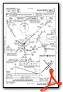
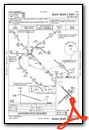
Instrument Approach Procedure (IAP) Charts


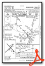


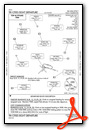
Departure Procedure (DP) Charts
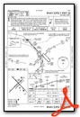
Departure Procedure Obstacles (DPO) Charts

Nearby Airports with Instrument Procedures
| ID | Name | Heading / Distance | ||
|---|---|---|---|---|
 |
KRLD | Richland Airport | 287° | 8.1 |
|
KHRI | Hermiston Municipal Airport | 192° | 26.9 |
|
KPDT | Eastern Oregon Regional At Pendleton Airport | 161° | 36.1 |
|
KALW | Walla Walla Regional Airport | 106° | 36.3 |
|
9S9 | Lexington Airport | 206° | 54.2 |
|
KMWH | Grant County International Airport | 351° | 57.2 |
|
KYKM | Yakima Air Trml/Mcallister Field Airport | 287° | 61.9 |
|
KEPH | Ephrata Municipal Airport | 345° | 64.7 |
|
KELN | Bowers Field Airport | 308° | 74.4 |
|
KLGD | La Grande/Union County Airport | 141° | 74.9 |
|
KEAT | Pangborn Memorial Airport | 327° | 81.5 |
|
KLWS | Lewiston/Nez Perce County Airport | 084° | 87.7 |
Airport Images
Do you have a recent image of this airport? Upload it here!


