Login
Register


EVM
Eveleth/Virginia Municipal Airport
Official FAA Data Effective 2026-02-19 0901Z
Chart Supplement

VFR Chart of KEVM
Sectional Charts at SkyVector.com
IFR Chart of KEVM
Enroute Charts at SkyVector.com
Location Information for KEVM
Coordinates: N47°25.45' / W92°29.79'Located 03 miles SE of Eveleth, Minnesota on 433 acres of land. View all Airports in Minnesota.
Surveyed Elevation is 1376 feet MSL.
Operations Data
|
|
Airport Communications
| AWOS-3: | 118.825 Tel. 218-744-2369 |
|---|---|
| DULUTH APPROACH: | 125.45 233.7 |
| DULUTH DEPARTURE: | 125.45 233.7 |
| UNICOM: | 122.700 |
| CTAF: | 122.700 |
| ASOS at HIB (14.1 W): | 126.425 218-263-8384 |
| AWOS-3 at CQM (25.1 N): | 118.175 218-666-2539 |
| AWOS-3PT at ELO (36.1 NE): | 132.025 218-365-3814 |
Nearby Navigation Aids
|
| ||||||||||||||||||||||||||||||||||||||||||||||||||||||


Runway 09/27
| Dimensions: | 4000 x 75 feet / 1219 x 23 meters | |
|---|---|---|
| Surface: | Asphalt in Good Condition | |
| Weight Limits: | S-12 | |
| Edge Lighting: | Medium Intensity | |
| Runway 09 | Runway 27 | |
| Coordinates: | N47°25.43' / W92°30.21' | N47°25.39' / W92°29.25' |
| Elevation: | 1374.3 | 1370.0 |
| Traffic Pattern: | Left | Left |
| Runway Heading: | 94° True | 274° True |
| Markings: | Non-Precision Instrument in good condition. | Non-Precision Instrument in good condition. |
| Glide Slope Indicator | P4L (3.00° Glide Path Angle) | P4L (3.00° Glide Path Angle) |
| REIL: | Yes | |
Runway 14/32
NOT PLOWED WINTER MONTHS; USBL WITH SKIS. | ||
| Dimensions: | 2050 x 100 feet / 625 x 30 meters | |
|---|---|---|
| Surface: | Turf in Fair Condition | |
| Weight Limits: | S-10 | |
| Edge Lighting: | Medium Intensity | |
| Runway 14 | Runway 32 | |
| Coordinates: | N47°25.65' / W92°30.08' | N47°25.40' / W92°29.75' |
| Elevation: | 1376.0 | 1370.3 |
| Traffic Pattern: | Left | Left |
| Runway Heading: | 139° True | 319° True |
| Markings: | Basic in good condition. | Basic in good condition. |
Services Available
| Fuel: | 100LL (blue), Jet-A |
|---|---|
| Transient Storage: | Tiedowns |
| Airframe Repair: | NONE |
| Engine Repair: | NONE |
| Bottled Oxygen: | NONE |
| Bulk Oxygen: | NONE |
Ownership Information
| Ownership: | Publicly owned | |
|---|---|---|
| Owner: | EVELETH & VIRGINIA CITIES | |
| 413 PIERCE ST, PO BOX 401 | CITY OF VIRGINIA CITY CLERK, 327 1ST ST S, VIRGINIA, MN 55792-2623. | |
| EVELETH, MN 55734-0401 | ||
| 218-744-6175 | CITY OF VIRGINIA 218-748-7500. | |
| Manager: | TED LEWIS | |
| 413 PIERCE STREET | ||
| EVELETH, MN 04094-4094 | ||
| 218-748-1271 | ||
Other Remarks
- DEER & BIRDS ON & INVOF ARPT.
- PAVEMENT HEAVING ON RAMP NEAR HNGR.
- FOR CD CTC DULUTH APCH AT 218-740-5950.
- 0LL SELF SERVE JET A AND AVGAS.
- ACTVT OR INCR INTST REIL RWY 27; PAPI RWY 09 & 27; MIRL RWY 09/27 & 14/32 - CTAF. MIRL RWY 09/27 & 14/32 PRESET LOW INTST.
Weather Minimums


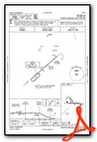
Instrument Approach Procedure (IAP) Charts

Nearby Airports with Instrument Procedures
| ID | Name | Heading / Distance | ||
|---|---|---|---|---|
 |
KHIB | Range Regional Airport | 260° | 14.1 |
|
12D | Tower Municipal Airport | 019° | 25.1 |
|
KCQM | Cook Municipal Airport | 341° | 25.2 |
|
KELO | Ely Municipal Airport | 048° | 36.2 |
|
KDLH | Duluth International Airport | 160° | 37.1 |
|
KTWM | Richard B Helgeson Airport | 125° | 38.1 |
|
KORB | Orr Regional Airport | 337° | 38.4 |
|
KGPZ | Grand Rapids/Itasca County-Gordon Newstrom Field Airport | 253° | 43.3 |
|
KCOQ | Cloquet/Carlton County Airport | 180° | 43.4 |
|
KDYT | Sky Harbor Airport | 156° | 46.0 |
|
KSUW | Richard I Bong Airport | 159° | 47.1 |
|
KFOZ | Bigfork Municipal Airport | 295° | 51.6 |
Airport Images
Do you have a recent image of this airport? Upload it here!


