Login
Register


GBD
Great Bend Municipal Airport
Official FAA Data Effective 2025-12-25 0901Z
Chart Supplement

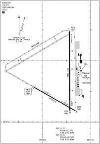
KGBD Airport Diagram
VFR Chart of KGBD
Sectional Charts at SkyVector.com
IFR Chart of KGBD
Enroute Charts at SkyVector.com
Location Information for KGBD
Coordinates: N38°20.66' / W98°51.55'Located 04 miles W of Great Bend, Kansas on 1887 acres of land. View all Airports in Kansas.
Surveyed Elevation is 1886 feet MSL.
Operations Data
|
|
Airport Communications
| AWOS-3PT: | 119.275 Tel. 620-792-5019 |
|---|---|
| CTAF: | 122.800 |
| UNICOM: | 122.800 |
| AWOS-3PT at LQR (13.4 SW): | 119.875 620-285-8552 |
| AWOS-3P at LYO (29.8 E): | 119.925 620-509-2357 |
| ASOS at RSL (31.8 N): | 128.325 785-483-5770 |
- COMMUNICATIONS PRVDD BY WICHITA RADIO ON FREQ 122.5 (GREAT BEND RCO).
- APCH/DEP CTL SVC PRVDD BY KANSAS CITY ARTCC (ZKC) ON FREQS 118.8/322.425 (HUTCHINSON RCAG).
Nearby Navigation Aids
|
| ||||||||||||||||||||||||||||||||||||||||||||||||||||||||||||


Runway 17/35
| Dimensions: | 7852 x 100 feet / 2393 x 30 meters | |
|---|---|---|
| Surface: | Concrete / Aggregate Friction Seal Coated in Fair Condition | |
| Weight Limits: | 19 /R/C/X/U, S-28, D-35, ST-86 | |
| Edge Lighting: | Medium Intensity | |
| Runway 17 | Runway 35 | |
| Coordinates: | N38°21.47' / W98°51.44' | N38°20.18' / W98°51.43' |
| Elevation: | 1881.3 | 1882.5 |
| Traffic Pattern: | Left | Left |
| Runway Heading: | 180° True | 360° True |
| Declared Distances: | TORA:7852 TODA:7852 ASDA:7852 LDA:7852 | TORA:7852 TODA:7852 ASDA:7852 LDA:7852 |
| Markings: | Non-Precision Instrument in good condition. | Precision Instrument in good condition. |
| Glide Slope Indicator | P4L (3.50° Glide Path Angle) | V4L (3.00° Glide Path Angle) |
| Approach Lights: | MALSR 1,400 Foot Medium-intensity Approach Lighting System with runway alignment indicator lights. | |
| REIL: | Yes | |
Runway 11/29
| Dimensions: | 4706 x 75 feet / 1434 x 23 meters | |
|---|---|---|
| Surface: | Asphalt in Fair Condition | |
| Weight Limits: | 9 /R/C/X/U, S-28, D-35, ST-86 | |
| Edge Lighting: | Medium Intensity | |
| Runway 11 | Runway 29 | |
| Coordinates: | N38°20.56' / W98°52.17' | N38°20.18' / W98°51.32' |
| Elevation: | 1886.7 | 1882.7 |
| Traffic Pattern: | Left | Left |
| Runway Heading: | 120° True | 300° True |
| Declared Distances: | TORA:4706 TODA:4706 ASDA:4706 LDA:4706 | TORA:4706 TODA:4706 ASDA:4706 LDA:4706 |
| Markings: | Non-Precision Instrument in good condition. | Non-Precision Instrument in good condition. |
| Glide Slope Indicator | P4L (3.00° Glide Path Angle) | P4L (3.00° Glide Path Angle) |
Services Available
| Fuel: | 100LL (blue), Jet-A |
|---|---|
| Transient Storage: | Hangars,Tiedowns |
| Airframe Repair: | MAJOR |
| Engine Repair: | MAJOR |
| Bottled Oxygen: | NOT AVAILABLE |
| Bulk Oxygen: | LOW |
| Other Services: | CROP DUSTING SERVICES,AIR AMBULANCE SERVICES,PILOT INSTRUCTION |
Ownership Information
| Ownership: | Publicly owned | |
|---|---|---|
| Owner: | CITY OF GREAT BEND | |
| 1209 WILLIAMS ST, CITY HALL, BOX 1168 | ||
| GREAT BEND, KS 67530 | ||
| 620-793-4111 | ||
| Manager: | MARTIN MILLER | |
| 9047 6TH ST,, BOX 1168 | ||
| GREAT BEND, KS 67530 | ||
| 620-793-4168 | AMGR CELL 620-792-9446. | |
Other Remarks
- CALM WIND RWY 17.
- 100LL AND JET A SELF-SERVE FUEL AVBL N END OF TRML APRON. CALL FBO 620-796-2130 FOR FUEL PRICES.
- FOR CD IF UNA TO CTC ON FSS FREQ, CTC KANSAS CITY ARTCC AT 913-254-8508.
- 0LL 24 HR CREDIT CARD SVC AVBL.
- ACTVT MALSR RWY 35; REIL RWY 17; PAPI RWY 11, 17 & 29; VASI RWY 35; MIRL 11/29 & 17/35 - CTAF.
Weather Minimums
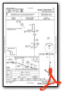
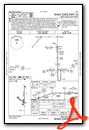
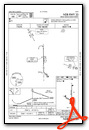
Instrument Approach Procedure (IAP) Charts
Nearby Airports with Instrument Procedures
| ID | Name | Heading / Distance | ||
|---|---|---|---|---|
 |
KLQR | Larned-Pawnee County Airport | 232° | 13.4 |
|
KLYO | Lyons-Rice County Municipal Airport | 090° | 29.8 |
|
KRSL | Russell Municipal Airport | 004° | 31.7 |
|
KHYS | Hays Regional Airport | 327° | 35.6 |
|
9K7 | Ellsworth Municipal Airport | 050° | 38.4 |
|
KPTT | Pratt Regional Airport | 172° | 38.8 |
|
KHUT | Hutchinson Regional Airport | 109° | 50.1 |
|
48K | Ness City Municipal Airport | 279° | 50.1 |
|
9K8 | Kingman/Clyde Cessna Field Airport | 139° | 53.4 |
|
K79 | Jetmore Municipal Airport | 246° | 53.5 |
|
KMPR | Mc Pherson Airport | 089° | 55.1 |
|
KSLN | Salina Regional Airport | 064° | 62.8 |
Airport Images

By: Big Orange Bird


