Login
Register


9K7
Ellsworth Municipal Airport
Official FAA Data Effective 2026-02-19 0901Z
Chart Supplement

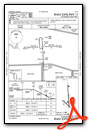
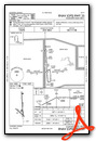
VFR Chart of 9K7
Sectional Charts at SkyVector.com
IFR Chart of 9K7
Enroute Charts at SkyVector.com
Location Information for 9K7
Coordinates: N38°45.06' / W98°13.75'Located 01 miles N of Ellsworth, Kansas on 160 acres of land. View all Airports in Kansas.
Surveyed Elevation is 1632 feet MSL.
Operations Data
|
|
Airport Communications
| AWOS-3PT: | 119.675 Tel. 785-472-9746 |
|---|---|
| UNICOM: | 122.700 |
| CTAF: | 122.700 |
| AWOS-3P at LYO (24.5 S): | 119.925 620-509-2357 |
| ASOS at SLN (27.1 E): | 120.15 785-823-3402 |
| ATIS at SLN (27.1 E): | 120.15 |
- APCH/DEP CTL SVC PRVDD BY KANSAS CITY ARTCC (ZKC) ON 134.9/363.2 (SALINA RCAG).
Nearby Navigation Aids
|
| ||||||||||||||||||||||||||||||||||||||||||||||||||||||||||||


Runway 17/35
| Dimensions: | 4500 x 75 feet / 1372 x 23 meters | |
|---|---|---|
| Surface: | Concrete in Excellent Condition | |
| Weight Limits: | 5 /F/C/Y/U | |
| Edge Lighting: | Medium Intensity | |
| Runway 17 | Runway 35 | |
| Coordinates: | N38°45.51' / W98°13.75' | N38°44.77' / W98°13.70' |
| Elevation: | 1632.9 | 1608.7 |
| Traffic Pattern: | Left | Left |
| Runway Heading: | 177° True | 357° True |
| Markings: | Non-Precision Instrument in good condition. | Non-Precision Instrument in good condition. |
| Glide Slope Indicator | P4L (3.00° Glide Path Angle) | P4L (3.00° Glide Path Angle) |
| REIL: | Yes | Yes |
Runway 13/31
| Dimensions: | 1955 x 100 feet / 596 x 30 meters | |
|---|---|---|
| Surface: | Turf in Good Condition | |
| Runway 13 | Runway 31 | |
| Coordinates: | N38°44.98' / W98°13.97' | N38°44.77' / W98°13.66' |
| Elevation: | 1609.4 | 1607.3 |
| Traffic Pattern: | Left | Left |
| Runway Heading: | 131° True | 311° True |
Services Available
| Fuel: | 100LL (blue) |
|---|---|
| Transient Storage: | Tiedowns |
| Airframe Repair: | NONE |
| Engine Repair: | NONE |
| Bottled Oxygen: | NONE |
| Bulk Oxygen: | NONE |
| Other Services: | CROP DUSTING SERVICES |
Ownership Information
| Ownership: | Publicly owned | |
|---|---|---|
| Owner: | CITY OF ELLSWORTH | |
| 121 W. 1ST ST., PO BOX 163 | ||
| ELLSWORTH, KS 67439 | ||
| 785-472-5566 | ||
| Manager: | DUSTIN STAMBAUGH | |
| 121 W 1ST ST | ||
| ELLSWORTH, KS 67439 | ||
| 785-472-5566 | ||
Other Remarks
- RWY 35 APCH- TALL FENCES, TOWERS & STADIUM STYLE FLOOD LIGHTS.
- UNATTENDED ARPT PH 785-472-5608.
- FOR CD CTC KANSAS CITY ARTCC AT 913-254-8508.
- 0LL FUEL AVBL 24 HR SELF SERVE. FOR ASST 785-472-4416.
- ACTVT REIL RWY 17 & 35, PAPI RWY 17 & 35; MIRL RWY 17/35 - CTAF.
Weather Minimums


Instrument Approach Procedure (IAP) Charts
Nearby Airports with Instrument Procedures
| ID | Name | Heading / Distance | ||
|---|---|---|---|---|
 |
KLYO | Lyons-Rice County Municipal Airport | 179° | 24.6 |
|
KSLN | Salina Regional Airport | 084° | 27.2 |
|
KRSL | Russell Municipal Airport | 284° | 28.3 |
|
KMPR | Mc Pherson Airport | 133° | 34.8 |
|
KGBD | Great Bend Municipal Airport | 230° | 38.4 |
|
K61 | Moritz Memorial Airport | 006° | 43.5 |
|
KHUT | Hutchinson Regional Airport | 156° | 44.6 |
|
47K | Moundridge Municipal Airport | 133° | 47.2 |
|
K78 | Abilene Municipal Airport | 078° | 47.5 |
|
KHYS | Hays Regional Airport | 276° | 49.3 |
|
KLQR | Larned-Pawnee County Airport | 231° | 51.8 |
|
KCNK | Blosser Municipal Airport | 029° | 54.9 |
Airport Images
Do you have a recent image of this airport? Upload it here!


