Login
Register


HUT
Hutchinson Regional Airport
Official FAA Data Effective 2026-01-22 0901Z
Chart Supplement

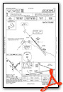
KHUT Airport Diagram

VFR Chart of KHUT
Sectional Charts at SkyVector.com
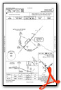
IFR Chart of KHUT
Enroute Charts at SkyVector.com
Location Information for KHUT
Coordinates: N38°3.97' / W97°51.63'Located 03 miles E of Hutchinson, Kansas on 1597 acres of land. View all Airports in Kansas.
Surveyed Elevation is 1542 feet MSL.
Operations Data
|
|
Airport Communications
| ATIS: | 124.25 |
|---|---|
| ASOS: | Tel. 620-662-1071 |
| HUTCHINSON TOWER: | 118.5 363.0 |
| HUTCHINSON GROUND: | 121.9 |
| WICHITA APPROACH: | 125.5 306.2 |
| WICHITA DEPARTURE: | 125.5 306.2 |
| UNICOM: | 122.950 |
| CTAF: | 118.500 |
| EMERG: | 121.5 243.0 |
| AWOS-3P at MPR (18.8 NE): | 119.025 620-798-1650 |
| AWOS-3P at LYO (24.0 NW): | 119.925 620-509-2357 |
| AWOS-3PT at 9K8 (26.8 SW): | 119.325 620-532-1272 |
Nearby Navigation Aids
|
| ||||||||||||||||||||||||||||||||||||||||||||||||||||||||||||


Runway 13/31
| Dimensions: | 7003 x 100 feet / 2135 x 30 meters | |
|---|---|---|
| Surface: | Asphalt in Excellent Condition | |
| Weight Limits: | 17 /F/D/X/T, S-44, D-58, ST-103 | |
| Edge Lighting: | High Intensity | |
| Runway 13 | Runway 31 | |
| Coordinates: | N38°4.45' / W97°52.26' | N38°3.59' / W97°51.29' |
| Elevation: | 1524.9 | 1514.7 |
| Traffic Pattern: | Left | Left |
| Runway Heading: | 138° True | 318° True |
| Declared Distances: | TORA:7003 TODA:7003 ASDA:7003 LDA:7003 | TORA:7003 TODA:7003 ASDA:7003 LDA:7003 |
| Markings: | Precision Instrument in fair condition. | Non-Precision Instrument in fair condition. |
| Glide Slope Indicator | V4L (3.00° Glide Path Angle) | |
| RVR Equipment | Touchdown | Rollout |
| Approach Lights: | MALSR 1,400 Foot Medium-intensity Approach Lighting System with runway alignment indicator lights. | |
| REIL: | Yes | |
| Obstacles: | 38 ft Tree 1627 ft from runway, 550 ft right of center | |
Runway 04/22
| Dimensions: | 4405 x 100 feet / 1343 x 30 meters | |
|---|---|---|
| Surface: | Asphalt in Fair Condition | |
| Weight Limits: | S-42, D-52, ST-76 | |
| Edge Lighting: | Medium Intensity | |
| Runway 04 | Runway 22 | |
| Coordinates: | N38°3.70' / W97°51.60' | N38°4.24' / W97°50.98' |
| Elevation: | 1516.5 | 1542.5 |
| Traffic Pattern: | Left | Left |
| Runway Heading: | 42° True | 222° True |
| Declared Distances: | TORA:4401 TODA:4401 ASDA:4401 LDA:4401 | TORA:4401 TODA:4401 ASDA:4401 LDA:4401 |
| Markings: | Non-Precision Instrument in good condition. | Non-Precision Instrument in good condition. |
| Glide Slope Indicator | P4L (3.00° Glide Path Angle) | V2L (3.40° Glide Path Angle) |
| REIL: | Yes | Yes |
| Obstacles: | 88 ft Trees 1450 ft from runway, 300 ft right of center | |
Runway 17/35
| Dimensions: | 4012 x 75 feet / 1223 x 23 meters | |
|---|---|---|
| Surface: | Concrete in Excellent Condition | |
| Weight Limits: | 14 /R/B/W/T, S-43, D-58, ST-76 | |
| Edge Lighting: | Medium Intensity | |
| Runway 17 | Runway 35 | |
| Coordinates: | N38°4.20' / W97°51.77' | N38°3.54' / W97°51.73' |
| Elevation: | 1523.3 | 1517.8 |
| Traffic Pattern: | Left | Left |
| Runway Heading: | 177° True | 357° True |
| Declared Distances: | TORA:4012 TODA:4012 ASDA:4012 LDA:4012 | TORA:4012 TODA:4012 ASDA:4012 LDA:4012 |
| Markings: | Non-Precision Instrument in good condition. | Non-Precision Instrument in good condition. |
| Glide Slope Indicator | P4L (3.00° Glide Path Angle) | P4L (3.00° Glide Path Angle) |
Services Available
| Fuel: | 100LL (blue), Jet-A |
|---|---|
| Transient Storage: | Hangars,Tiedowns |
| Airframe Repair: | MAJOR |
| Engine Repair: | MAJOR |
| Bottled Oxygen: | NONE |
| Bulk Oxygen: | LOW |
| Other Services: | AIR FREIGHT SERVICES,CHARTER SERVICE,PILOT INSTRUCTION,AIRCRAFT RENTAL |
Ownership Information
| Ownership: | Publicly owned | |
|---|---|---|
| Owner: | CITY OF HUTCHINSON | |
| 125 E AVENUE B, P O BOX 1567 | ||
| HUTCHINSON, KS 67504 | ||
| 620-694-2611 | ||
| Manager: | ALEK STANG, C.M. | |
| 1100 N. AIRPORT ROAD, STE 112 | ||
| HUTCHINSON, KS 67501 | ||
| 620-259-4192 | ||
Other Remarks
- MIGRATORY BIRDS ON & INVOF ARPT.
- CROSSING RWYS USED FOR TAXIING TO AND FM ACTIVE RWYS.
- ARPT SFC CONDS UNMON FM 0300Z-1100Z.
- FOR CD CTC WICHITA APCH AT 316-350-1520.
- TWY B3 DSGND AS A NON-MOVEMENT AREA.
- 0LL SELF SERVICE 100LL FUEL AVBL N OF THE TRANSIENT APRON
- ACTVT MALSR RWY 13; PAPI RWY 4, 17, 35; VASI RWY 22; MIRL RWY 04/22 & 17/35; HIRL RWY 13/31 - CTAF.
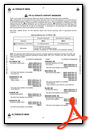
Weather Minimums

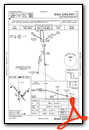
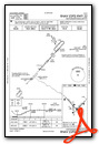
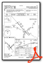
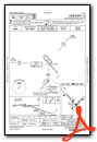
Instrument Approach Procedure (IAP) Charts


Nearby Airports with Instrument Procedures
| ID | Name | Heading / Distance | ||
|---|---|---|---|---|
 |
KMPR | Mc Pherson Airport | 024° | 18.9 |
|
47K | Moundridge Municipal Airport | 063° | 19.0 |
|
KLYO | Lyons-Rice County Municipal Airport | 313° | 23.9 |
|
9K8 | Kingman/Clyde Cessna Field Airport | 207° | 26.9 |
|
KEWK | Newton-City-County Airport | 090° | 27.7 |
|
KICT | Wichita Dwight D Eisenhower Ntl Airport | 140° | 32.2 |
|
KAAO | Colonel James Jabara Airport | 121° | 35.9 |
|
KBEC | Beech Factory Airport | 125° | 37.9 |
|
KCEA | Cessna Acft Field Airport | 130° | 38.3 |
|
KIAB | Mc Connell AFB Airport | 133° | 38.7 |
|
1K1 | Lloyd Stearman Field Airport | 116° | 39.6 |
|
3AU | Augusta Municipal Airport | 122° | 44.1 |
Fuel Providers

Airport Images

By: Big Orange Bird


Comments
Great Steakhouse
The Hutchinson Airport Steakhouse is hands down the best airport restaurant in Kansas. We've always had great service there and the Sunday brunch is legendary!