Login
Register
GCN
Grand Canyon Ntl Park Airport
Official FAA Data Effective 2025-12-25 0901Z
From the Flight Deck
VFR Chart of KGCN
Sectional Charts at SkyVector.com
IFR Chart of KGCN
Enroute Charts at SkyVector.com
Location Information for KGCN
Coordinates: N35°57.14' / W112°8.82'Located 06 miles S of Grand Canyon, Arizona on 859 acres of land. View all Airports in Arizona.
Surveyed Elevation is 6608 feet MSL.
Operations Data
|
|
Airport Communications
| ATIS: | 124.3 |
|---|---|
| ASOS: | 124.3 Tel. 928-638-0672 |
| CANYON TOWER: | 119.0 |
| CANYON GROUND: | 121.9 |
| EMERG: | 121.5 |
| UNICOM: | 122.950 |
| CTAF: | 119.000 |
| AWOS-3 at CMR (39.2 S): | 121.125 928-635-1278 |
| ASOS at FLG (53.9 SE): | 125.8 928-216-3910 |
| ATIS at FLG (54.1 SE): | 125.8 |
- APCH/DEP CTL SVC PRVDD BY LOS ANGELES ARTCC (ZLA) ON FREQS 124.85/319.2 (SELIGMAN RCAG).
- COMMUNICATIONS PRVDD BY PRESCOTT RADIO ON FREQ 122.4 (GRAND CANYON RCO) WHEN ATCT IS CLSD.
- COMMUNICATIONS PRVDD BY PRESCOTT RADIO ON FREQ 122.3 (COTTONWOOD RCO).
Nearby Navigation Aids
|
| ||||||||||||||||||||||||||||||||||||
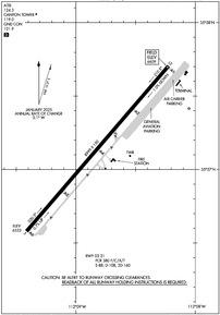
Runway 03/21
LGTD DSTC RMNG SIGNS E SIDE. | ||
| Dimensions: | 8999 x 150 feet / 2743 x 46 meters | |
|---|---|---|
| Surface: | Asphalt / Grooved in Fair Condition | |
| Weight Limits: | S-88, D-108, ST-160
PCR VALUE: 380/F/C/X/T
| |
| Edge Lighting: | Medium Intensity | |
| Runway 03 | Runway 21 | |
| Coordinates: | N35°56.58' / W112°9.41' | N35°57.70' / W112°8.22' |
| Elevation: | 6533.1 | 6608.8 |
| Traffic Pattern: | Right | |
| Runway Heading: | 41° True | 221° True |
| Declared Distances: | TORA:8999 TODA:8999 ASDA:8999 LDA:8999 | TORA:8999 TODA:8999 ASDA:8999 LDA:8999 |
| Markings: | Precision Instrument in good condition. | Non-Precision Instrument in good condition. |
| Glide Slope Indicator | P4R (4.00° Glide Path Angle) | |
| REIL: | Yes | |
Services Available
| Fuel: | 100LL (blue), Jet-A |
|---|---|
| Transient Storage: | Tiedowns |
| Airframe Repair: | MINOR |
| Engine Repair: | MAJOR |
| Bottled Oxygen: | LOW |
| Bulk Oxygen: | LOW |
| Other Services: | AIR FREIGHT SERVICES,AVIONICS,CHARTER SERVICE,PARACHUTE JUMP ACTIVITY |
Ownership Information
| Ownership: | Publicly owned | |
|---|---|---|
| Owner: | STATE OF ARIZONA | |
| DEPARTMENT OF TRANS-ASD, 206 S. 17TH AVE MD178 | ||
| PHOENIX, AZ 85007 | ||
| (602) 712-6255 | ||
| Manager: | DAVID REFFNER | |
| PO BOX 3399 | ||
| GRAND CANYON, AZ 86023 | ||
| 623-695-8656 | ||
Other Remarks
- CONDORS INVOF ARPT.
- NMRS AIR TAX OPS INVOF GRAND CANYON; SEE SPL NOTICES GRAND CANYON SPL FLT RULES AREA.
- ARFF INDEX B 24 HR PPR - AMGR.
- FOR CD IF UNA TO CTC ON FSS FREQ, CTC LOS ANGELES ARTCC AT 661-575-2079.
- OVNGT PRKG & COML LNDG FEE.
- 0LL AVBL H24 - 928-638-7117.
- WHEN ATCT CLSD ACTVT PAPI RWY 21; MIRL RWY 03/21 - CTAF.
Weather Minimums
Instrument Approach Procedure (IAP) Charts
Departure Procedure (DP) Charts
Departure Procedure Obstacles (DPO) Charts
Nearby Airports with Instrument Procedures
| ID | Name | Heading / Distance | ||
|---|---|---|---|---|
 |
40G | Valle Airport | 180° | 18.1 |
 |
KCMR | H A Clark Memorial Field Airport | 183° | 38.8 |
 |
KFLG | Flagstaff Pulliam Airport | 154° | 54.0 |
 |
KKNB | Kanab Municipal Airport | 343° | 66.1 |
 |
KPGA | Page Municipal Airport | 029° | 67.4 |
 |
KSEZ | Sedona Airport | 165° | 68.4 |
 |
KAZC | Colorado City Municipal Airport | 325° | 73.5 |
 |
P52 | Cottonwood Airport | 175° | 73.4 |
 |
KPRC | Prescott Regional/Ernest A Love Field Airport | 189° | 78.9 |
 |
KINW | Winslow-Lindbergh Regional Airport | 128° | 89.3 |
 |
KSGU | St George Regional Airport | 314° | 92.6 |
 |
KIGM | Kingman Airport | 245° | 97.0 |


