Login
Register


P52
Cottonwood Airport
Official FAA Data Effective 2026-02-19 0901Z
Chart Supplement

VFR Chart of P52
Sectional Charts at SkyVector.com
IFR Chart of P52
Enroute Charts at SkyVector.com
Location Information for P52
Coordinates: N34°43.80' / W112°2.11'Located 01 miles SW of Cottonwood, Arizona on 210 acres of land. View all Airports in Arizona.
Surveyed Elevation is 3560 feet MSL.
TPA HELICOPTER 4050 MSL/500 AGL; SINGLE 4350 MSL/800 AGL; MULTI 4550 MSL/1000 AGL; TURBINE 5050 MSL/1500 AGL.
Operations Data
|
|
Airport Communications
| AWOS-3: | 119.925 Tel. 928-634-0916 |
|---|---|
| PHOENIX APPROACH: | 126.375 236.775 |
| PHOENIX DEPARTURE: | 126.375 236.775 |
| CTAF: | 122.700 |
| UNICOM: | 122.700 |
| AWOS-3PT at SEZ (14.0 NE): | 118.525 928-282-1993 |
| ASOS at PRC (19.3 W): | 127.2 928-541-3850 |
| ATIS at PRC (19.5 W): | 127.2 |
- APCH/DEP SVC PRVDD BY PHOENIX TRACON (P50) ON FREQ 126.375/236.775.
- COMMUNICATIONS PRVDD BY PRESCOTT RADIO ON FREQ 122.3 (COTTONWOOD RCO).
Nearby Navigation Aids
|
| ||||||||||||||||||||||||||||||||||||


Runway 14/32
RWY 32 CALM WIND RWY. | ||
| Dimensions: | 4250 x 75 feet / 1295 x 23 meters 300 FT PAVED STWY BOTH ENDS. | |
|---|---|---|
| Surface: | Asphalt in Good Condition | |
| Weight Limits: | S-4 | |
| Edge Lighting: | Medium Intensity | |
| Runway 14 | Runway 32 | |
| Coordinates: | N34°44.12' / W112°2.28' | N34°43.48' / W112°1.93' |
| Elevation: | 3519.4 | 3560.3 |
| Traffic Pattern: | Left | Right |
| Runway Heading: | 156° True | 336° True |
| Markings: | Basic in fair condition. | Non-Precision Instrument in fair condition. |
| Glide Slope Indicator | P2L (3.00° Glide Path Angle) | P2L (3.60° Glide Path Angle) |
| REIL: | Yes | Yes |
| Obstacles: | 8 ft Brush 201 ft from runway, 144 ft left of center 12 FT BRUSH 50-200 FT FM THR 120-175 FT R OF CNTRLN; 15 FT BRUSH 0-200 FT FM THR 60-250 FT L OF CNTRLN; 4 FT BERM 30-200 FT FM THR 125-250 FT L OF CNTRLN. |
|
Services Available
| Fuel: | 100LL (blue) |
|---|---|
| Transient Storage: | Hangars,Tiedowns CALL AHEAD FOR AVBL. |
| Airframe Repair: | NOT AVAILABLE |
| Engine Repair: | NOT AVAILABLE |
| Bottled Oxygen: | NOT AVAILABLE |
| Bulk Oxygen: | NOT AVAILABLE |
| Other Services: | AIR AMBULANCE SERVICES,PILOT INSTRUCTION,AIRCRAFT RENTAL |
Ownership Information
| Ownership: | Publicly owned | |
|---|---|---|
| Owner: | CITY OF COTTONWOOD | |
| 827 N MAIN ST | ||
| COTTONWOOD, AZ 86326 | ||
| 928-634-5526 | ||
| Manager: | ROD PROPST | |
| 1001 W MINGUS AVE, COTTONWOOD MUNICIPAL AIRPORT | ||
| COTTONWOOD, AZ 86326 | ||
| 928-340-2722 | EMERG - POLICE 928-634-4246. | |
Other Remarks
- FOR CD CTC PHOENIX APCH AT 602-306-2565.
- USE VY AIRSPEED UNTIL 1000 FT.
- REPETITIVE FLT TRNG NA 1800-0800 WKDAY & 1800-0900 WKEND & HOL. MORE THAN FOUR ACFT CONDUCTING REPETITIVE FLT TRNG IN PAT NA.
- GLIDERS & WILDLIFE INVOF ARPT.
- 0LL H24 WITH CREDIT CARD.
- ACTVT REIL RWY 14 & 32; PAPI RWY 14 & 32; MIRL RWY 14/32 - CTAF.
- TPA HELICOPTER 4050 MSL/500 AGL; SINGLE 4350 MSL/800 AGL; MULTI 4550 MSL/1000 AGL; TURBINE 5050 MSL/1500 AGL.
Weather Minimums

Instrument Approach Procedure (IAP) Charts

Departure Procedure Obstacles (DPO) Charts

Nearby Airports with Instrument Procedures
| ID | Name | Heading / Distance | ||
|---|---|---|---|---|
 |
KSEZ | Sedona Airport | 059° | 14.1 |
|
KPRC | Prescott Regional/Ernest A Love Field Airport | 256° | 19.5 |
|
KFLG | Flagstaff Pulliam Airport | 036° | 30.5 |
|
KCMR | H A Clark Memorial Field Airport | 347° | 35.4 |
|
KPAN | Payson Airport | 129° | 44.7 |
|
40G | Valle Airport | 354° | 55.4 |
|
KDVT | Phoenix Deer Valley Airport | 182° | 62.4 |
|
KSDL | Scottsdale Airport | 174° | 66.6 |
|
KINW | Winslow-Lindbergh Regional Airport | 074° | 67.1 |
|
KGEU | Glendale Regional Airport | 190° | 73.2 |
|
KGCN | Grand Canyon Ntl Park Airport | 355° | 73.4 |
|
KLUF | Luke AFB Airport | 193° | 73.6 |
Airport Images
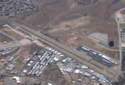
By: timmonst@cox.net
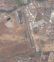
By: Dave


Comments
FYI,
FYI,
P52 CTAF is 122.7: see NOTAM 11/052
Please change.
Thanks
RH
P52 freq
P52 freq is out of date. Should read 122.70 not 122.80. Please change, Thanks
Updating airport information
Updating airport information needs to be done by the airport manager with the FAA. Posting here is the best option for a temporary fix, until the FAA gets updated.
JM
Admin