Login
Register


HYX
Saginaw County/H W Browne Airport
Official FAA Data Effective 2025-11-27 0901Z
Chart Supplement

VFR Chart of KHYX
Sectional Charts at SkyVector.com
IFR Chart of KHYX
Enroute Charts at SkyVector.com
Location Information for KHYX
Coordinates: N43°26.00' / W83°51.74'Located 04 miles E of Saginaw, Michigan on 293 acres of land. View all Airports in Michigan.
Surveyed Elevation is 601 feet MSL.
Operations Data
|
|
Airport Communications
| AWOS-3PT: | 118.325 Tel. 989-752-3408 |
|---|---|
| GREAT LAKES APPROACH: | 120.95 235.625 |
| GREAT LAKES DEPARTURE: | 120.95 235.625 |
| UNICOM: | 122.800 |
| CTAF: | 122.800 |
| ATIS at MBS (11.2 NW): | 125.925 |
| ASOS at MBS (11.2 NW): | 989-695-2488 |
| AWOS-3 at CFS (18.2 E): | 119.275 989-672-4182 |
- APCH/DEP SVC PRVDD BY CLEVELAND ARTCC (ZOB) ON FREQS 127.7/290.425 (FREELAND RCAG) WHEN GREAT LAKES APCH CTL CLSD.
Nearby Navigation Aids
|
| ||||||||||||||||||||||||||||||||||||||||||||||||||||||


Runway 10/28
| Dimensions: | 5002 x 100 feet / 1525 x 30 meters | |
|---|---|---|
| Surface: | Asphalt in Excellent Condition | |
| Weight Limits: | S-60, D-72, ST-101 | |
| Edge Lighting: | High Intensity | |
| Runway 10 | Runway 28 | |
| Coordinates: | N43°26.03' / W83°52.31' | N43°26.04' / W83°51.18' |
| Elevation: | 598.7 | 597.3 |
| Traffic Pattern: | Left | Left |
| Runway Heading: | 90° True | 270° True |
| Markings: | Non-Precision Instrument in good condition. | Precision Instrument in good condition. |
| Glide Slope Indicator | P4L (3.00° Glide Path Angle) | P4L (3.00° Glide Path Angle) |
| Approach Lights: | MALSF 1,400 Foot Medium-intensity Approach Lighting System with sequenced flashers. | |
| REIL: | Yes | |
| Obstacles: | 4 ft Brush 229 ft from runway, 313 ft right of center | 66 ft Trees 842 ft from runway, 620 ft left of center |
Runway 05/23
| Dimensions: | 2952 x 60 feet / 900 x 18 meters | |
|---|---|---|
| Surface: | Asphalt in Good Condition | |
| Weight Limits: | S-12 | |
| Edge Lighting: | Medium Intensity | |
| Runway 05 | Runway 23 | |
| Coordinates: | N43°25.77' / W83°51.96' | N43°26.12' / W83°51.49' |
| Elevation: | 600.8 | 597.9 |
| Traffic Pattern: | Left | Left |
| Runway Heading: | 45° True | 225° True |
| Displaced Threshold: | 119 Feet | 129 Feet |
| Markings: | Basic in good condition. | Basic in good condition. |
| Glide Slope Indicator | P2L (3.00° Glide Path Angle) | P2R (3.00° Glide Path Angle) |
| Obstacles: | 6 ft Fence 200 ft from runway, 120 ft right of center APCH RATIO 20:1 TO DTHR. |
15 ft Road 210 ft from runway, 126 ft right of center APCH RATIO 20:1 TO DTHR. 2 FT CONC CULVERT, 100 FT DIST, 80 FT L; -15 FT DITCH, ACRS APCH END. |
Services Available
| Fuel: | 100LL (blue), Jet A+ |
|---|---|
| Transient Storage: | Tiedowns |
| Airframe Repair: | MAJOR |
| Engine Repair: | MAJOR |
| Bottled Oxygen: | NOT AVAILABLE |
| Bulk Oxygen: | NOT AVAILABLE |
| Other Services: | PILOT INSTRUCTION,AIRCRAFT RENTAL |
Ownership Information
| Ownership: | Publicly owned | |
|---|---|---|
| Owner: | COUNTY OF SAGINAW | |
| 4821 JANES RD | ||
| SAGINAW, MI 48601-9656 | ||
| 989-758-2459 | ||
| Manager: | ALAN KAUFMAN | |
| 4789 JANES RD | ||
| SAGINAW, MI 48601 | ||
| 989-295-0675 | ||
Other Remarks
- DEER & LRG BIRDS ON & INVOF ARPT.
- FOR CD CTC GREAT LAKES APCH AT 269-459-3345, WHEN APCH CLSD CTC CLEVELAND ARTCC AT 440-774-0224/0490.
- 0LL 100LL & JET A+ AVBL H24 SELF SVC.
- ACTVT MALSF RWY 28; REIL RWY 10; PAPI RWY 05, 23, 10, & 28; HIRL RWY 10/28; MIRL RWY 05/23 - CTAF. PAPI RWY 10 & 28 OPR CONSLY DURG DALGT HRS.
Weather Minimums


Instrument Approach Procedure (IAP) Charts

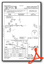
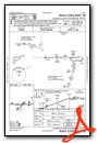
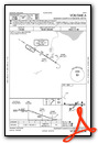
Nearby Airports with Instrument Procedures
| ID | Name | Heading / Distance | ||
|---|---|---|---|---|
 |
3CM | James Clements Municipal Airport | 348° | 7.0 |
|
KMBS | Mbs International Airport | 302° | 11.2 |
|
KCFS | Tuscola Area Airport | 085° | 18.3 |
|
KIKW | Jack Barstow Airport | 308° | 22.2 |
|
KFNT | Bishop International Airport | 169° | 28.5 |
|
KRNP | Owosso Community Airport | 204° | 29.1 |
|
D95 | Dupont/Lapeer Airport | 130° | 34.0 |
|
77G | Marlette Township Airport | 101° | 34.5 |
|
KAMN | Gratiot Community Airport | 259° | 36.7 |
|
9G2 | Prices Airport | 173° | 37.8 |
|
KMOP | Mount Pleasant Municipal Airport | 286° | 39.8 |
|
KGDW | Gladwin Zettel Memorial Airport | 320° | 41.8 |
Airport Images

By: sunmanav8


