Login
Register


GIF
Winter Haven Regional Airport
Official FAA Data Effective 2025-12-25 0901Z
Chart Supplement

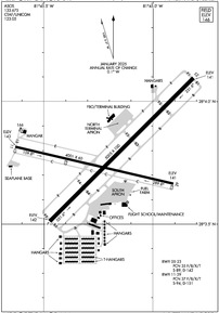
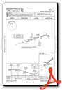
KGIF Airport Diagram
VFR Chart of KGIF
Sectional Charts at SkyVector.com
IFR Chart of KGIF
Enroute Charts at SkyVector.com
Location Information for KGIF
Coordinates: N28°3.78' / W81°45.20'Located 03 miles NW of Winter Haven, Florida on 520 acres of land. View all Airports in Florida.
Surveyed Elevation is 145 feet MSL.
Operations Data
|
|
Airport Communications
| ASOS: | 133.675 Tel. 863-956-2097 |
|---|---|
| TAMPA APPROACH: | 119.9 120.65 290.3 |
| TAMPA DEPARTURE: | 119.9 120.65 290.3 |
| CTAF: | 123.050 |
| UNICOM: | 123.050 |
| AWOS-3 at BOW (7.1 S): | 123.775 863-533-9004 |
| AWOS-3 at X07 (12.5 SE): | 124.225 863-678-1334 |
| ATIS at LAL (14.8 W): | 118.025 |
Nearby Navigation Aids
|
| ||||||||||||||||||||||||||||||||||||||||||


Runway 05/23
| Dimensions: | 5005 x 100 feet / 1526 x 30 meters | |
|---|---|---|
| Surface: | Asphalt in Fair Condition | |
| Weight Limits: | 35 /F/B/X/T, S-89, D-142 | |
| Edge Lighting: | Medium Intensity | |
| Runway 05 | Runway 23 | |
| Coordinates: | N28°3.51' / W81°45.47' | N28°4.10' / W81°44.81' |
| Elevation: | 141.6 | 141.2 |
| Traffic Pattern: | Left | Left |
| Runway Heading: | 45° True | 225° True |
| Markings: | Non-Precision Instrument in fair condition. | Non-Precision Instrument in fair condition. |
| Glide Slope Indicator | P2L (3.00° Glide Path Angle) | P2L (3.00° Glide Path Angle) |
| REIL: | Yes | Yes |
| Obstacles: | 5 ft Fence 205 ft from runway, 250 ft left of center RWY 05 APCH SLOPE 16:1 TO AER DUE TO 33 FT TREES 515 FT FM RWY END AND 150 FT LEFT . |
41 ft Trees 1245 ft from runway, 65 ft left of center |
Runway 11/29
| Dimensions: | 4001 x 60 feet / 1220 x 18 meters | |
|---|---|---|
| Surface: | Asphalt in Good Condition | |
| Weight Limits: | 37 /F/B/X/T, S-94, D-151 | |
| Edge Lighting: | Medium Intensity | |
| Runway 11 | Runway 29 | |
| Coordinates: | N28°3.81' / W81°45.63' | N28°3.66' / W81°44.91' |
| Elevation: | 143.0 | 141.1 |
| Traffic Pattern: | Left | Left |
| Runway Heading: | 103° True | 283° True |
| Markings: | Non-Precision Instrument in fair condition. | Basic in fair condition. |
| REIL: | Yes | Yes |
| Obstacles: | 43 ft Power Line 1430 ft from runway, 70 ft left of center | 5 ft Fence 215 ft from runway, 250 ft left of center |
Services Available
| Fuel: | 100LL (blue), Jet-A, Automotive Gasoline |
|---|---|
| Transient Storage: | Hangars,Tiedowns |
| Airframe Repair: | MAJOR |
| Engine Repair: | MAJOR |
| Bottled Oxygen: | NONE |
| Bulk Oxygen: | NONE |
| Other Services: | AVIONICS,PILOT INSTRUCTION,AIRCRAFT RENTAL,AIRCRAFT SALES |
Ownership Information
| Ownership: | Publicly owned | |
|---|---|---|
| Owner: | CITY OF WINTER HAVEN | CONTACT PERSON: T. MICHAEL STAVRES |
| P.O. BOX 2277 | ||
| WINTER HAVEN, FL 33883-2277 | ||
| 863-291-5600 | ||
| Manager: | TROY HEIDEL | |
| 2073 HWY 92 WEST | ||
| WINTER HAVEN, FL 33881 | ||
| 863-298-4551 | ||
Other Remarks
- BROWN'S SPB LOCATED ON ADJACENT LAKE.
- NMRS ACFT OPERG WO RDOS INVOF ARPT AND SPB.
- UNLGTD OBSTNS IN THE APPRCH TO RWY 05 DUE TO TREES 515 BFR AER.
- ANEMOMETER REMOTED TO FBO OFFICE.
- GLIDER ACFT OPERG ON AND INVOF ARPT.
- GCO AVBL ON FREQ 121.725 THRU TAMPA CD.
- RWY 05 PREFERRED FOR CALM OR LIGHT WINDS
- FOR CD IF UNA VIA GCO CTC TAMPA APCH AT 813-878-2528.
- ACTVT REIL RWY 11 & 29; PAPI RWY 05 & 23; MIRL RWY 05/23 & 11/29 - CTAF.
Weather Minimums
Instrument Approach Procedure (IAP) Charts

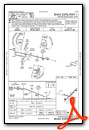
Nearby Airports with Instrument Procedures
| ID | Name | Heading / Distance | ||
|---|---|---|---|---|
 |
KBOW | Bartow Exec Airport | 192° | 7.3 |
|
X07 | Lake Wales Municipal Airport | 145° | 12.3 |
|
KLAL | Lakeland Linder International Airport | 252° | 14.8 |
|
KISM | Kissimmee Gateway Airport | 050° | 21.6 |
|
KPCM | Plant City Airport | 260° | 22.1 |
|
KZPH | Zephyrhills Municipal Airport | 294° | 23.5 |
|
KAVO | Avon Park Exec Airport | 157° | 30.6 |
|
KVDF | Tampa Exec Airport | 264° | 31.6 |
|
KMCO | Orlando International Airport | 046° | 32.2 |
|
KCHN | Wauchula Municipal Airport | 191° | 33.5 |
|
KORL | Orlando Exec Airport | 037° | 36.5 |
|
KTPF | Peter O Knight Airport | 256° | 38.0 |
Airport Images
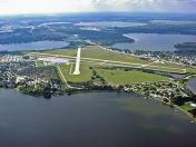
By: youngeaglesflyer
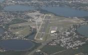
By: carlrai


