Login
Register


X07
Lake Wales Municipal Airport
Official FAA Data Effective 2025-12-25 0901Z
Chart Supplement

VFR Chart of X07
Sectional Charts at SkyVector.com
IFR Chart of X07
Enroute Charts at SkyVector.com
Location Information for X07
Coordinates: N27°53.59' / W81°37.29'Located 02 miles W of Lake Wales, Florida on 520 acres of land. View all Airports in Florida.
Surveyed Elevation is 126 feet MSL.
Operations Data
|
|
Airport Communications
| AWOS-3: | 124.225 Tel. 863-678-1334 |
|---|---|
| UNICOM: | 122.800 |
| CTAF: | 122.800 |
| AWOS-3 at BOW (9.1 W): | 123.775 863-533-9004 |
| ASOS at GIF (12.4 NW): | 133.675 863-956-2097 |
| AWOS-3 at AVO (18.7 S): | 118.725 863-453-4223 |
- APCH/DEP SVC PRVDD BY MIAMI ARTCC ON FREQS 134.55/257.7 (AVON PARK RCAG).
Nearby Navigation Aids
|
| ||||||||||||||||||||||||||||||||||||||||||||||||


Runway 06/24
| Dimensions: | 5400 x 100 feet / 1646 x 30 meters | |
|---|---|---|
| Surface: | Asphalt / Grooved in Good Condition | |
| Weight Limits: | 6 /F/B/Y/T, S-15 | |
| Edge Lighting: | Medium Intensity | |
| Runway 06 | Runway 24 | |
| Coordinates: | N27°53.31' / W81°37.75' | N27°53.76' / W81°36.89' |
| Elevation: | 123.4 | 121.4 |
| Traffic Pattern: | Left | Left |
| Runway Heading: | 59° True | 239° True |
| Markings: | Non-Precision Instrument in fair condition. | Non-Precision Instrument in fair condition. |
| Glide Slope Indicator | P4L (3.50° Glide Path Angle) | P4L (3.50° Glide Path Angle) |
| REIL: | Yes | Yes |
| Obstacles: | 36 ft Trees 1305 ft from runway, 300 ft left of center | 51 ft Trees 1770 ft from runway, 165 ft right of center |
Runway 17/35
| Dimensions: | 3860 x 75 feet / 1177 x 23 meters | |
|---|---|---|
| Surface: | Asphalt in Fair Condition | |
| Weight Limits: | 8 /F/B/Y/T, S-15 | |
| Runway 17 | Runway 35 | |
| Coordinates: | N27°53.98' / W81°37.32' | N27°53.36' / W81°37.16' |
| Elevation: | 123.6 | 122.3 |
| Traffic Pattern: | Left | Left |
| Runway Heading: | 167° True | 347° True |
| Markings: | Basic in fair condition. | Basic in fair condition. |
| Glide Slope Indicator | P2R (3.37° Glide Path Angle) | P2L (3.00° Glide Path Angle) |
| Obstacles: | 18 ft Trees 410 ft from runway, 125 ft right of center | |
Services Available
| Fuel: | 100LL (blue), Jet-A |
|---|---|
| Transient Storage: | Tiedowns |
| Airframe Repair: | NONE |
| Engine Repair: | NONE |
| Bottled Oxygen: | NONE |
| Bulk Oxygen: | NONE |
| Other Services: | PARACHUTE JUMP ACTIVITY |
Ownership Information
| Ownership: | Publicly owned | |
|---|---|---|
| Owner: | LAKE WALES AIRPORT AUTHORITY | CONTACT PERSON: JAMES SLATON |
| CITY ADMINISTRATION BUILDING, 201 CENTRAL AVENUE WEST | ||
| LAKE WALES, FL 33853-1320 | ||
| 863-678-4182 | ||
| Manager: | AMANDA LOMNECK | |
| 450 SOUTH AIRPORT RD | ||
| LAKE WALES, FL 33859-1320 | ||
| 863-678-0080 | ||
Other Remarks
- ULTRALIGHT ACTIVITY ON & INVOF ARPT.
- TREES IN TRANSITIONAL SFC RY 17; APCH WEST OF RY.
- FOR CD CTC MIAMI ARTCC AT 305-716-1731.
- 0LL FUEL AVBL 24 HR CREDIT CARD SVC.
- ACTVT REIL RWY 6 & 24; PAPI RWY 17 & 35; MIRL RWY 6/ 24 - CTAF. PAPI 6 & 24 OPR CONSLY.
Weather Minimums
Instrument Approach Procedure (IAP) Charts

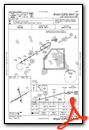
Nearby Airports with Instrument Procedures
| ID | Name | Heading / Distance | ||
|---|---|---|---|---|
 |
KBOW | Bartow Exec Airport | 289° | 9.1 |
|
KGIF | Winter Haven Regional Airport | 325° | 12.3 |
|
KAVO | Avon Park Exec Airport | 164° | 18.7 |
|
KLAL | Lakeland Linder International Airport | 285° | 21.9 |
|
KISM | Kissimmee Gateway Airport | 022° | 25.7 |
|
KCHN | Wauchula Municipal Airport | 211° | 26.5 |
|
KPCM | Plant City Airport | 282° | 29.5 |
|
KSEF | Sebring Regional Airport | 150° | 30.1 |
|
KZPH | Zephyrhills Municipal Airport | 305° | 34.7 |
|
KMCO | Orlando International Airport | 027° | 36.1 |
|
KVDF | Tampa Exec Airport | 280° | 39.1 |
|
KORL | Orlando Exec Airport | 021° | 41.9 |
Airport Images

By: Cardinal


