Login
Register


GJT
Grand Junction Regional Airport
Official FAA Data Effective 2026-02-19 0901Z
Chart Supplement

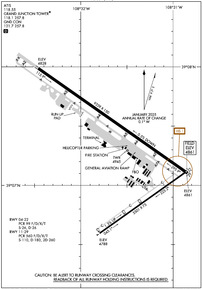
KGJT Airport Diagram
VFR Chart of KGJT
Sectional Charts at SkyVector.com
IFR Chart of KGJT
Enroute Charts at SkyVector.com
Location Information for KGJT
Coordinates: N39°7.29' / W108°31.53'Located 03 miles NE of Grand Junction, Colorado on 2357 acres of land. View all Airports in Colorado.
Surveyed Elevation is 4861 feet MSL.
Operations Data
|
|
Airport Communications
| ATIS: | 118.55 |
|---|---|
| ASOS: | 118.55 Tel. 970-462-9228 |
| GRAND JUNCTION TOWER: | 118.1 257.8 |
| GRAND JUNCTION GROUND: | 121.7 257.8 |
| DENVER APPROACH: | 119.7 317.4 |
| DENVER DEPARTURE: | 119.7 317.4 |
| IC: | 121.7 |
| UNICOM: | 122.950 |
| VFR ADZY: | 118.1 |
| CTAF: | 118.100 |
| AWOS-3 at AJZ (29.4 SE): | 134.0 970-874-3251 |
| ASOS at RIL (44.7 NE): | 135.275 970-625-2206 |
| ASOS at MTJ (47.2 SE): | 135.225 970-249-1534 |
- FREQ 121.5 NOT AVBL.
- DENVER APCH (D01) PRVDS APCH/DEP CTL SVC FM 0600-2200; DENVER ARTCC (ZDV) PRVDS APCH/DEP CTL SVC FM 2200-0600 ON 134.5/327.8 (GRAND MESA/B/ RCAG).
- COMMUNICATIONS PRVDD BY DENVER RADIO ON FREQ 122.6 (GRAND JUNCTION RCO).
Nearby Navigation Aids
|
| ||||||||||||||||||||||||||||||||||||

Runway 11/29
| Dimensions: | 9339 x 150 feet / 2847 x 46 meters | |
|---|---|---|
| Surface: | Asphalt / Grooved in Excellent Condition | |
| Weight Limits: | S-110, D-180, ST-260
PCR VALUE: 560/F/D/X/T
| |
| Edge Lighting: | High Intensity | |
| Runway 11 | Runway 29 | |
| Coordinates: | N39°7.99' / W108°32.46' | N39°7.10' / W108°30.85' |
| Elevation: | 4827.9 | 4861.4 |
| Traffic Pattern: | Left | Left |
| Runway Heading: | 125° True | 305° True |
| Declared Distances: | TORA:9339 TODA:9339 ASDA:9339 LDA:9339 | TORA:9339 TODA:9339 ASDA:9339 LDA:9339 |
| Markings: | Precision Instrument in fair condition. | Precision Instrument in fair condition. |
| Glide Slope Indicator | P4L (3.00° Glide Path Angle) | V4L (3.00° Glide Path Angle) |
| RVR Equipment | Touchdown | Rollout |
| Approach Lights: | MALSF 1,400 Foot Medium-intensity Approach Lighting System with sequenced flashers. | |
| REIL: | Yes | |
Runway 04/22
RWY 04/22 CLSD FM 2200-0600. | ||
| Dimensions: | 5501 x 75 feet / 1677 x 23 meters | |
|---|---|---|
| Surface: | Asphalt / Grooved in Good Condition | |
| Weight Limits: | S-26, D-26
PCR VALUE: 99/F/D/X/T
| |
| Edge Lighting: | Medium Intensity | |
| Runway 04 | Runway 22 | |
| Coordinates: | N39°6.59' / W108°31.79' | N39°7.12' / W108°30.85' |
| Elevation: | 4787.6 | 4860.8 |
| Traffic Pattern: | Left | Left |
| Runway Heading: | 54° True | 234° True |
| Declared Distances: | TORA:5501 TODA:5501 ASDA:5501 LDA:5501 | TORA:5501 TODA:5501 ASDA:5501 LDA:5501 |
| Markings: | Basic in fair condition. | Basic in fair condition. |
| Glide Slope Indicator | P4L (3.00° Glide Path Angle) | |
| REIL: | Yes | Yes |
Services Available
| Fuel: | 100LL (blue), Jet-A |
|---|---|
| Transient Storage: | Hangars,Tiedowns |
| Airframe Repair: | MAJOR |
| Engine Repair: | MAJOR |
| Bottled Oxygen: | HIGH |
| Bulk Oxygen: | HIGH LIQUID OXY SVC AVBL. |
| Other Services: | AIR FREIGHT SERVICES,AIR AMBULANCE SERVICES,AVIONICS,CARGO HANDLING SERVICES,CHARTER SERVICE,PILOT INSTRUCTION,AIRCRAFT RENTAL,AIRCRAFT SALES |
Ownership Information
| Ownership: | Publicly owned | |
|---|---|---|
| Owner: | GRAND JUNCTION REG ARPT AUTH | |
| 2828 WALKER FLD DR SUITE 301 | ||
| GRAND JUNCTION, CO 81506 | ||
| 970-244-9100 | ||
| Manager: | ANGELA PADALECKI | |
| 2828 WALKER FIELD DRIVE SUITE 301 | ||
| GRAND JUNCTION, CO 81506 | ||
Other Remarks
- TWY C1A & TWY C, 150 FT EITHER SIDE OF THE INTXN NOT VSBL FM ATCT.
- CONDITIONS NOT MONITORED 0000-0530 LOCAL TIME EXCEPT BY PPR.
- CD FONE: WHEN TWR CLSD, CTC GRAND JUNCTION APCH 303-342-1916. IFUN, CTC DENVER ARTCC 303-342-4257.
- HEL PRKG AVBL AT FBO; PPR RCMDD.
- FLOCKS OF BIRDS ON & INVOF ARPT.
- NOISE ABATEMENT PROCEDURES IN EFCT, CTC ARPT MGMT FOR DETAILS AT (970) 244-9100.
- JASU: 1(MD-3A), 1(NC-10A/A1/BC), 2(AM32A-60B).
- FLUID: SP, LHOX LOX, LHNIT, DE-ICE(MIL A-8243).
- ARPT OPS NUMBER IS 970-260-7164. PLEASE CALL FOR ANY NOTAMS OR CONCERNS.
- WHEN ATCT CLSD ACTVT MALSF RWY 11; HIRL RWY 11/29; TWY LGTS - CTAF. REIL RWY 29; PAPI RWY 11; VASI RWY 29 ON CONSLY. REIL RWY 04 & 22; PAPI RWY 04; MIRL RWY 04/22 ON CONSLY DURG ATCT OPER HRS AND OFF WHEN ATCT CLSD.
Weather Minimums
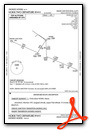
Instrument Approach Procedure (IAP) Charts


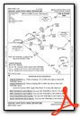
Departure Procedure (DP) Charts

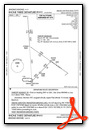
Departure Procedure Obstacles (DPO) Charts

Nearby Airports with Instrument Procedures
| ID | Name | Heading / Distance | ||
|---|---|---|---|---|
 |
KAJZ | Blake Field Airport | 132° | 29.6 |
|
KRIL | Rifle Garfield County Airport | 056° | 44.4 |
|
KMTJ | Montrose Regional Airport | 140° | 47.1 |
|
KAIB | Hopkins Field Airport | 181° | 52.9 |
|
4V0 | Rangely Airport | 349° | 59.3 |
|
KCNY | Canyonlands Regional Airport | 249° | 61.5 |
|
KEEO | Meeker Coulter Field Airport | 027° | 63.0 |
|
KTEX | Telluride Regional Airport | 157° | 75.8 |
|
KASE | Aspen-Pitkin County/Sardy Field Airport | 085° | 77.6 |
|
U34 | Green River Municipal Airport | 263° | 80.1 |
|
KEGE | Eagle County Regional Airport | 066° | 81.1 |
|
U64 | Monticello Airport | 208° | 81.0 |
Airport Images
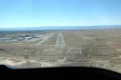
By: GJTom


