Login
Register


RIL
Rifle Garfield County Airport
Official FAA Data Effective 2026-01-22 0901Z
Chart Supplement

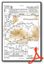
VFR Chart of KRIL
Sectional Charts at SkyVector.com
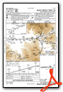
IFR Chart of KRIL
Enroute Charts at SkyVector.com
Location Information for KRIL
Coordinates: N39°31.60' / W107°43.68'Located 03 miles E of Rifle, Colorado on 517 acres of land. View all Airports in Colorado.
Surveyed Elevation is 5536 feet MSL.
Operations Data
|
|
Airport Communications
| ASOS: | 135.275 Tel. 970-625-2206 |
|---|---|
| UNICOM: | 122.800 |
| CTAF: | 122.800 |
| AWOS-3 at 5SM (17.3 E): | 126.075 970-384-3380 |
| ASOS at EEO (32.2 N): | 135.525 970-878-5036 |
| AWOS-3PT at EGE (38.2 E): | 135.575 970-524-7386 |
- APCH/DEP CTL SVC PRVDD BY DENVER ARTCC (ZDV) ON FREQS 134.95/327.075 (RIFLE RCAG).
Nearby Navigation Aids
|
| ||||||||||||||||||||||||||||||||||||

Runway 08/26
| Dimensions: | 7000 x 100 feet / 2134 x 30 meters | |
|---|---|---|
| Surface: | Asphalt / Grooved in Good Condition | |
| Weight Limits: | 43 /F/B/X/U, S-90, D-200, ST-250 | |
| Edge Lighting: | High Intensity | |
| Runway 08 | Runway 26 | |
| Coordinates: | N39°31.58' / W107°44.42' | N39°31.61' / W107°42.94' |
| Elevation: | 5470.2 | 5536.8 |
| Traffic Pattern: | Left | Right |
| Runway Heading: | 88° True | 268° True |
| Markings: | Non-Precision Instrument in good condition. | Precision Instrument in good condition. |
| Glide Slope Indicator | P4L (3.00° Glide Path Angle) | P4L (3.50° Glide Path Angle) |
| Approach Lights: | ODALS Omnidirectional Approach Lighting System | |
| REIL: | Yes | |
| Obstacles: | 6 ft Tower 331 ft from runway, 307 ft left of center | |
Services Available
| Fuel: | 100LL (blue), Jet-A |
|---|---|
| Transient Storage: | Hangars,Tiedowns |
| Airframe Repair: | MAJOR |
| Engine Repair: | MAJOR |
| Bottled Oxygen: | LOW |
| Bulk Oxygen: | HIGH |
| Other Services: | AIR FREIGHT SERVICES,AIR AMBULANCE SERVICES,CHARTER SERVICE,PILOT INSTRUCTION,AIRCRAFT RENTAL |
Ownership Information
| Ownership: | Publicly owned | |
|---|---|---|
| Owner: | GARFIELD COUNTY | |
| 0375 COUNTY RD 352 BLDG 2060 | ||
| RIFLE, CO 81650 | ||
| 970-625-1091 | ||
| Manager: | SAM CARVER | |
| 0375 COUNTY RD 352 BLDG 2060 | ||
| RIFLE, CO 81650 | ||
| 970-625-1091 | ||
Other Remarks
- IFR ATC CLNC FM RIL IS NOT AUTH TO ENTER RWY OR TKOF & LNDG.
- SATURATED PAT POLICY: TGLS PROHIBITED WHEN 5 OR MORE ACFT IN TFC PATTERN.
- FLW FAA PROCS FOR NON-TOWERED ARPTS.
- CTN: SN REMOVAL EQUIP OPS FM 1 OCT TO 15 MAY.
- AFT WINTER SN STORMS ARPT OPNS BFR ALL TWYS ARE CLEARED.
- OVNGT PRKG FEE.
- COLD TEMPERATURE AIRPORT. ALTITUDE CORRECTION REQUIRED AT OR BELOW -13C.
- FOR CD, IFUN TO CTC ON DENVER ARTCC APP/DEP CTL FREQ, CTC DENVER ARTCC AT 303-651-4257.
- GLD OPS INVOF ARPT.
- PROPER DUAL RDO USE (ATC/CTAF) IS ESNTL FOR SAFE AND EFFICIENT TFC FLOW.
- USE CTAF PRIOR TO ENTERING RWY OR PAT.
- 0LL ARPT OPS-24 HRS / 970-230-1685.
- ACTVT ODALS RWY 26; REIL RWY 08; HIRL RWY 08/26 - CTAF. PAPI RWY 08 & 26 ON CONSLY.
- FOR ACFT GWT 10000 LBS OR MORE.
Weather Minimums

Standard Terminal Arrival (STAR) Charts

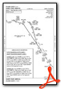

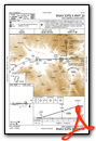
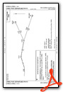
Instrument Approach Procedure (IAP) Charts


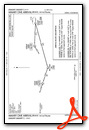
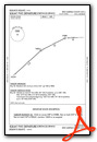
Departure Procedure (DP) Charts
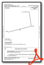
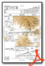
Departure Procedure Obstacles (DPO) Charts
Nearby Airports with Instrument Procedures
| ID | Name | Heading / Distance | ||
|---|---|---|---|---|
 |
KEEO | Meeker Coulter Field Airport | 346° | 32.1 |
|
KEGE | Eagle County Regional Airport | 079° | 38.3 |
|
KASE | Aspen-Pitkin County/Sardy Field Airport | 114° | 44.0 |
|
KGJT | Grand Junction Regional Airport | 237° | 44.4 |
|
KAJZ | Blake Field Airport | 199° | 47.1 |
|
4V0 | Rangely Airport | 305° | 58.7 |
|
KCAG | Craig-Moffat Airport | 009° | 58.8 |
|
KMTJ | Montrose Regional Airport | 187° | 61.4 |
|
KHDN | Yampa Valley Airport | 022° | 61.9 |
|
KLXV | Lake County Airport | 105° | 68.2 |
|
KGUC | Gunnison-Crested Butte Regional Airport | 147° | 70.2 |
|
20V | Mc Elroy Airfield Airport | 062° | 70.3 |
Airport Images

By: rifleairport


