Login
Register


GLH
Greenville Mid-Delta Airport
Official FAA Data Effective 2026-02-19 0901Z
Chart Supplement

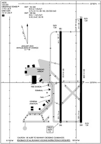
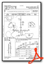
KGLH Airport Diagram
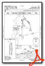
VFR Chart of KGLH
Sectional Charts at SkyVector.com
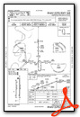
IFR Chart of KGLH
Enroute Charts at SkyVector.com
Location Information for KGLH
Coordinates: N33°29.11' / W90°59.07'Located 05 miles NE of Greenville, Mississippi on 2000 acres of land. View all Airports in Mississippi.
Surveyed Elevation is 130 feet MSL.
Operations Data
|
|
Airport Communications
| ASOS: | 125.525 Tel. 662-332-0863 |
|---|---|
| GREENVILLE TOWER: | 119.0 256.9 |
| GREENVILLE GROUND: | 121.8 256.9 |
| CTAF: | 119.000 |
| UNICOM: | 122.950 |
| EMERG: | 121.5 243.0 |
| AWOS-3PT at RNV (20.1 NE): | 124.175 662-843-3021 |
| ASOS at LLQ (39.4 W): | 133.325 870-367-1019 |
| ASOS at GWO (45.0 E): | 119.975 662-453-3304 |
- APCH/DEP SVC PRVDD BY MEMPHIS ARTCC ON FREQS 135.875/269.35 (GREENVILLE RCAG & PINE BLUFF RCAG).
Nearby Navigation Aids
|
| ||||||||||||||||||||||||||||||||||||||||||||||||||||||||||||


Runway 18L/36R
| Dimensions: | 8001 x 150 feet / 2439 x 46 meters | |
|---|---|---|
| Surface: | Asphalt / Grooved in Fair Condition | |
| Weight Limits: | 61 /F/D/X/T, S-75, D-112, ST-182, DT-540 | |
| Edge Lighting: | High Intensity | |
| Runway 18L | Runway 36R | |
| Coordinates: | N33°29.81' / W90°58.93' | N33°28.49' / W90°58.93' |
| Elevation: | 128.8 | 129.2 |
| Traffic Pattern: | Right | |
| Runway Heading: | 180° True | 0 |
| Declared Distances: | TORA:8001 TODA:8001 ASDA:7981 LDA:7981 | TORA:8001 TODA:8001 ASDA:8001 LDA:8001 |
| Markings: | Precision Instrument in good condition. | Precision Instrument in good condition. |
| Glide Slope Indicator | P4L (3.00° Glide Path Angle) | |
| RVR Equipment | Touchdown | |
| Approach Lights: | MALSR 1,400 Foot Medium-intensity Approach Lighting System with runway alignment indicator lights. | |
| REIL: | Yes | |
| Obstacles: | 84 ft Tree 3691 ft from runway, 478 ft left of center | |
Runway 18R/36L
NO TKOF OR LNDG AUTH FOR ACR ACFT. | ||
| Dimensions: | 7019 x 150 feet / 2139 x 46 meters | |
|---|---|---|
| Surface: | Asphalt-Concrete / Grooved in Poor Condition UNEVEN PAVEMENT. | |
| Weight Limits: | 11 /R/C/X/T, S-29, D-47, ST-78 | |
| Edge Lighting: | Medium Intensity | |
| Runway 18R | Runway 36L | |
| Coordinates: | N33°29.65' / W90°59.23' | N33°28.49' / W90°59.23' |
| Elevation: | 128.2 | 130.6 |
| Traffic Pattern: | Right | |
| Runway Heading: | 180° True | 360° True |
| Markings: | Non-Precision Instrument in poor condition. | Non-Precision Instrument in poor condition. |
| Glide Slope Indicator | P4L (3.00° Glide Path Angle) | P4L (3.00° Glide Path Angle) |
| Obstacles: | 56 ft Trees 1400 ft from runway, 425 ft left of center | |
Services Available
| Fuel: | 100LL (blue), Jet-A |
|---|---|
| Transient Storage: | Hangars,Tiedowns |
| Airframe Repair: | NONE |
| Engine Repair: | NONE |
| Bottled Oxygen: | NONE |
| Bulk Oxygen: | NONE |
| Other Services: | CROP DUSTING SERVICES,CARGO HANDLING SERVICES |
Ownership Information
| Ownership: | Publicly owned | |
|---|---|---|
| Owner: | CITY OF GREENVILLE | |
| 340 MAIN ST | ||
| GREENVILLE, MS 38701 | ||
| Manager: | LEVELL D. HAWKINS | |
| 166 FIFTH AVE STE 300 | ||
| GREENVILLE, MS 38703 | ||
| 662-334-3121 | ||
Other Remarks
- TWYS C & D ARE CLSD, TWY F NOT AVBL FOR ACR USE.
- FOR CD WHEN ATCT CLSD, CTC MEMPHIS ARTCC AT 901-368-8453/8449.
- CLSD TO SKED ACR OPS WITH MORE THAN 9 PAX SEATS & UNSKED ACR OPS WITH MORE THAN 30 PAX SEATS.
- SGFNT BIRD ACT INVOF RWYS.
- FUEL AVBL 7AM-5PM DLY, AFT HRS CALL 662-822-5269.
- MARKINGS FADED.
- MARKINGS FADED.
- WHEN ATCT CLSD ACTVT OR INCR INTST MALSR RWY 18L; MIRL RWY 18R/36L; HIRL RWY 18L/36R - CTAF. PAPI RWY 18R, 36L, & 36R OPR CONSLY; HIRL RWY 18L/36R PRESET MED INTST.
Weather Minimums


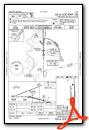
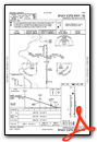
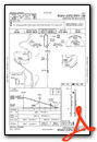
Instrument Approach Procedure (IAP) Charts
Nearby Airports with Instrument Procedures
| ID | Name | Heading / Distance | ||
|---|---|---|---|---|
 |
KIDL | Indianola Municipal Airport | 089° | 15.3 |
|
M32 | Lake Village Municipal Airport | 243° | 18.6 |
|
KRNV | Cleveland Municipal Airport | 034° | 20.1 |
|
7M1 | Mc Gehee Municipal Airport | 293° | 20.7 |
|
M37 | Ruleville-Drew Airport | 052° | 28.9 |
|
0M0 | Billy Free Municipal Airport | 311° | 36.5 |
|
KLLQ | Monticello Municipal/Ellis Field Airport | 283° | 39.5 |
|
87I | Yazoo County Airport | 143° | 44.6 |
|
KGWO | Greenwood-Leflore Airport | 089° | 45.1 |
|
KCRT | Z M Jack Stell Field Airport | 248° | 48.6 |
|
5M1 | Dewitt Municipal/Whitcomb Field Airport | 340° | 49.3 |
|
19M | C A Moore Airport | 113° | 52.8 |
Airport Images
Do you have a recent image of this airport? Upload it here!


