Login
Register


0M0
Billy Free Municipal Airport
Official FAA Data Effective 2026-01-22 0901Z
Chart Supplement

VFR Chart of 0M0
Sectional Charts at SkyVector.com
IFR Chart of 0M0
Enroute Charts at SkyVector.com
Location Information for 0M0
Coordinates: N33°53.07' / W91°32.06'Located 02 miles W of Dumas, Arkansas on 73 acres of land. View all Airports in Arkansas.
Surveyed Elevation is 164 feet MSL.
Operations Data
|
|
Airport Communications
| UNICOM: | 122.800 |
|---|---|
| CTAF: | 122.800 |
| ASOS at LLQ (18.3 SW): | 133.325 870-367-1019 |
| ASOS at PBF (26.5 NW): | 120.775 870-536-0228 |
| ASOS at GLH (36.3 SE): | 125.525 662-332-0863 |
- APCH/DEP SVC PRVDD BY MEMPHIS ARTCC ON FREQS 135.875/269.35 (GREENVILLE RCAG & PINE BLUFF RCAG).
Nearby Navigation Aids
|
| ||||||||||||||||||||||||||||||||||||||||||||||||||||||||||||


Runway 18/36
| Dimensions: | 5003 x 75 feet / 1525 x 23 meters | |
|---|---|---|
| Surface: | Asphalt in Fair Condition | |
| Weight Limits: | S-15 | |
| Edge Lighting: | Medium Intensity | |
| Runway 18 | Runway 36 | |
| Coordinates: | N33°53.48' / W91°32.04' | N33°52.66' / W91°32.08' |
| Elevation: | 163.8 | 163.2 |
| Runway Heading: | 182° True | 2° True |
| Markings: | Basic in fair condition. | Non-Precision Instrument in fair condition. |
| Glide Slope Indicator | P2L (3.00° Glide Path Angle) | |
Services Available
| Fuel: | 100LL (blue), Jet-A |
|---|---|
| Transient Storage: | Hangars,Tiedowns |
| Airframe Repair: | MAJOR |
| Engine Repair: | MAJOR |
| Bottled Oxygen: | NOT AVAILABLE |
| Bulk Oxygen: | NOT AVAILABLE |
| Other Services: | CROP DUSTING SERVICES |
Ownership Information
| Ownership: | Publicly owned | |
|---|---|---|
| Owner: | CITY OF DUMAS | |
| PO BOX 157 | ||
| DUMAS, AR 71639 | ||
| 870-382-2121 | ||
| Manager: | BRANNON WEST | |
| 202 BURNS RD | ||
| DUMAS, AR 71639 | ||
| 870-382-2216 | ||
Other Remarks
- MIGRATORY BIRDS ON AND INVOF ARPT NOV-FEB.
- FOR CD CTC MEMPHIS ARTCC AT 901-368-8453/8449.
- 0LL SELF SVC FUEL AVBL 24 HRS WITH CREDIT CARD (100LL & JET A)
- ACTVT PAPI RWY 36; MIRL RWY 18/36 - CTAF.
Weather Minimums

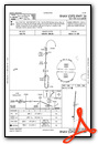
Instrument Approach Procedure (IAP) Charts
Nearby Airports with Instrument Procedures
| ID | Name | Heading / Distance | ||
|---|---|---|---|---|
 |
7M1 | Mc Gehee Municipal Airport | 151° | 18.0 |
|
KLLQ | Monticello Municipal/Ellis Field Airport | 216° | 18.3 |
|
5M1 | Dewitt Municipal/Whitcomb Field Airport | 026° | 25.3 |
|
KPBF | Pinebluff Regional/Grider Field Airport | 311° | 26.5 |
|
M73 | Almyra Municipal Airport | 006° | 31.8 |
|
3M9 | Warren Municipal/John B Frazer Jr Field Airport | 235° | 33.7 |
|
M32 | Lake Village Municipal Airport | 161° | 34.0 |
|
KGLH | Greenville Mid-Delta Airport | 130° | 36.5 |
|
KRNV | Cleveland Municipal Airport | 100° | 39.5 |
|
KSGT | Stuttgart Municipal Carl Humphrey Field Airport | 357° | 42.9 |
|
KCRT | Z M Jack Stell Field Airport | 202° | 45.7 |
|
9M8 | Sheridan-Grant County Regional Airport | 303° | 48.6 |
Airport Images
Do you have a recent image of this airport? Upload it here!


