Login
Register


GUP
Gallup Municipal Airport
Official FAA Data Effective 2026-02-19 0901Z
Chart Supplement

VFR Chart of KGUP
Sectional Charts at SkyVector.com
IFR Chart of KGUP
Enroute Charts at SkyVector.com
Location Information for KGUP
Coordinates: N35°30.66' / W108°47.36'Located 03 miles SW of Gallup, New Mexico on 359 acres of land. View all Airports in New Mexico.
Surveyed Elevation is 6472 feet MSL.
Operations Data
|
|
Airport Communications
| ASOS: | 118.375 Tel. 505-726-8232 |
|---|---|
| UNICOM: | 122.950 |
| CTAF: | 122.950 |
| ASOS at RQE (16.0 NW): | 118.325 928-900-4667 |
| AWOS-3PT at XNI (28.2 S): | 119.275 505-356-2876 |
| AWOS-3PT at GNT (48.1 SE): | 118.3 505-287-9890 |
- COMMUNICATIONS PRVDD BY ALBUQUERQUE RADIO ON FREQ 122.1R (GALLUP RCO).
- APCH/DEP SVC PRVDD BY ALBUQUERQUE ARTCC (ZAB) ON 124.325/288.25 (WEST MESA RCAG).
Nearby Navigation Aids
|
| ||||||||||||||||||||||||||||||||||||


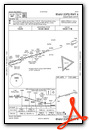
Runway 06/24
RWY 24 CALM WIND RWY. | ||
| Dimensions: | 7312 x 100 feet / 2229 x 30 meters | |
|---|---|---|
| Surface: | Asphalt in Good Condition | |
| Weight Limits: | 39 /F/C/X/T, S-45, D-55 | |
| Edge Lighting: | Medium Intensity | |
| Runway 06 | Runway 24 | |
| Coordinates: | N35°30.50' / W108°48.07' | N35°30.83' / W108°46.65' |
| Elevation: | 6464.6 | 6472.3 |
| Traffic Pattern: | Left | Left |
| Runway Heading: | 74° True | 254° True |
| Markings: | Non-Precision Instrument in good condition. | Non-Precision Instrument in good condition. |
| Glide Slope Indicator | P2L (3.00° Glide Path Angle) | P2L (3.00° Glide Path Angle) |
| REIL: | Yes | |
| Obstacles: | 34 ft Tree 1325 ft from runway, 50 ft left of center | 35 ft Tree 1375 ft from runway, 200 ft left of center |
Services Available
| Fuel: | 100LL (blue), Jet A-1+ |
|---|---|
| Transient Storage: | Hangars,Tiedowns AVBLTY - 505-879-6222. |
| Airframe Repair: | NOT AVAILABLE |
| Engine Repair: | NOT AVAILABLE |
| Bottled Oxygen: | NOT AVAILABLE |
| Bulk Oxygen: | NOT AVAILABLE |
| Other Services: | AIR FREIGHT SERVICES,AIR AMBULANCE SERVICES,CARGO HANDLING SERVICES,CHARTER SERVICE |
Ownership Information
| Ownership: | Publicly owned | |
|---|---|---|
| Owner: | CITY OF GALLUP | |
| BOX 1270 | ||
| GALLUP, NM 87305 | ||
| 505-863-1254 | ||
| Manager: | ROBERT HAMBLEN | |
| 110 WEST AZTEC | ||
| GALLUP, NM 87301 | ||
| 505-863-1290 | EMERG - AARON LESLIE 505-870-2788. | |
Other Remarks
- FOR CD IF UNA TO CTC ON FSS FREQ, CTC ALBUQUERQUE ARTCC AT 505-856-4561.
- SELF SVC FUEL H24 WITH CREDIT CARD. AFT HR FUEL CALL OUT FEE - 505-879-6222.
- ACTVT REIL RWY 24; MIRL RWY 06/24 - CTAF.
Weather Minimums
Instrument Approach Procedure (IAP) Charts


Nearby Airports with Instrument Procedures
| ID | Name | Heading / Distance | ||
|---|---|---|---|---|
 |
KRQE | Window Rock Airport | 301° | 16.0 |
|
KGNT | Grants-Milan Municipal Airport | 115° | 48.2 |
|
KSJN | St Johns Industrial Air Park Airport | 206° | 66.2 |
|
KFMN | Four Corners Regional Airport | 020° | 78.6 |
|
KJTC | Springerville Municipal Airport | 197° | 86.7 |
|
KTYL | Taylor Airport | 226° | 91.1 |
|
KSOW | Show Low Regional Airport | 219° | 95.8 |
|
KINW | Winslow-Lindbergh Regional Airport | 253° | 99.4 |
|
KAEG | Double Eagle II Airport | 102° | 100.3 |
|
KCEZ | Cortez Municipal Airport | 004° | 107.7 |
|
KBRG | Belen Regional Airport | 117° | 109.2 |
|
KDRO | Durango-La Plata County Airport | 026° | 110.4 |

 from SE")


Comments
New FBO as of Aug 2022
Stopped into KT Aero on 2 Aug. The transition to them as a new FBO is still in process. The line crew and management was friendly and helpful. However, there was an issue with the SelfServe pumps not charging the correct amount for fuel. The KT Aero team is working through this issue and hopefully it will be resolved soon. The facility looks fresh and they expect to provide full service soon.
Pages