Login
Register


SOW
Show Low Regional Airport
Official FAA Data Effective 2026-01-22 0901Z
Chart Supplement

VFR Chart of KSOW
Sectional Charts at SkyVector.com
IFR Chart of KSOW
Enroute Charts at SkyVector.com
Location Information for KSOW
Coordinates: N34°15.93' / W110°0.34'Located 02 miles E of Show Low, Arizona on 691 acres of land. View all Airports in Arizona.
Surveyed Elevation is 6415 feet MSL.
Operations Data
|
|
Airport Communications
| AWOS-3: | 118.075 Tel. 928-532-0379 |
|---|---|
| CTAF: | 123.000 |
| UNICOM: | 123.000 |
| AWOS-3PT at TYL (12.7 NW): | 119.075 928-387-2084 |
| AWOS-3PT at E24 (31.0 S): | 119.225 928-338-3411 |
| ASOS at SJN (34.6 NE): | 134.225 928-337-3061 |
- APCH/DEP SVC PRVDD BY ALBUQUERQUE ARTCC(ZAB) ON FREQS 132.9/239.05 (GLOBE NR 1 RCAG).
Nearby Navigation Aids
|
| ||||||||||||||||||||||||||||||||||||


Runway 07/25
| Dimensions: | 7202 x 100 feet / 2195 x 30 meters | |
|---|---|---|
| Surface: | Asphalt in Excellent Condition | |
| Weight Limits: | S-35, D-60
PCR VALUE: 269/F/D/X/T
| |
| Edge Lighting: | Medium Intensity | |
| Runway 07 | Runway 25 | |
| Coordinates: | N34°15.83' / W110°1.13' | N34°16.11' / W109°59.75' |
| Elevation: | 6399.2 | 6399.8 |
| Traffic Pattern: | Left | Right |
| Runway Heading: | 76° True | 256° True |
| Displaced Threshold: | 700 Feet | |
| Declared Distances: | TORA:7200 TODA:7200 ASDA:7200 LDA:6500 | TORA:7200 TODA:7200 ASDA:7200 LDA:7200 |
| Markings: | Non-Precision Instrument in good condition. | Non-Precision Instrument in good condition. |
| Glide Slope Indicator | P2L (3.00° Glide Path Angle) | P2L (3.00° Glide Path Angle) |
| REIL: | Yes | Yes |
Runway 04/22
RWY 04/22 NOT AVBL FOR PART 121/PART 380 OPS WITH SKED PAX CARRYING OPS MORE THAN 9 PAX SEATS AND NON-SKED PAX CARRYING OPS MORE THAN 30 PAX SEATS. | ||
| Dimensions: | 3938 x 60 feet / 1200 x 18 meters | |
|---|---|---|
| Surface: | Asphalt in Good Condition | |
| Weight Limits: | S-12
PCR VALUE: 65/F/D/Y/T
| |
| Runway 04 | Runway 22 | |
| Coordinates: | N34°15.63' / W110°0.45' | N34°16.07' / W109°59.87' |
| Elevation: | 6412.9 | 6400.6 |
| Traffic Pattern: | Right | |
| Runway Heading: | 48° True | 228° True |
| Declared Distances: | TORA:3938 TODA:3938 ASDA:3938 LDA:3938 | TORA:3938 TODA:3938 ASDA:3938 LDA:3938 |
| Markings: | Basic in good condition. | Basic in good condition. |
Services Available
| Fuel: | 100LL (blue), Jet-A |
|---|---|
| Transient Storage: | Tiedowns |
| Airframe Repair: | MINOR |
| Engine Repair: | MINOR |
| Bottled Oxygen: | NOT AVAILABLE |
| Bulk Oxygen: | NOT AVAILABLE |
| Other Services: | CHARTER SERVICE,PILOT INSTRUCTION,AIRCRAFT RENTAL |
Ownership Information
| Ownership: | Publicly owned | |
|---|---|---|
| Owner: | CITY OF SHOWLOW | |
| 180 N. 9TH PLACE | ||
| SHOW LOW, AZ 85901 | ||
| (928) 532-4000 | ||
| Manager: | JACOB ALLEN | |
| 3150 AIRPORT LOOP, #100 | ||
| SHOW LOW, AZ 85901 | ||
| 928-532-4190 | ||
Other Remarks
- PART 77 OBSTNS & WIND SOCK IN 7-1 TRSN.
- MIL TFC INVOF ARPT.
- OVNGT TSNT & COML OPS LNDG FEE.
- RWY 04/22 & 07/25 NOT CONNECTED BY PAVEMENT AT APCH END RWY 22.
- RWY 22 & 25 SIMUL OPS NA.
- FOR CD CTC ALBUQUERQUE ARTCC AT 505-856-4861.
- APCH RATIO 40:1 TO DTHR.
- 0LL SELF SVC FUEL H24.
- ACTVT REIL RWY 07 & 25; PAPI RWY 07 & 25; MIRL RWY 07/25 - CTAF.
Weather Minimums

Instrument Approach Procedure (IAP) Charts

Nearby Airports with Instrument Procedures
| ID | Name | Heading / Distance | ||
|---|---|---|---|---|
 |
KTYL | Taylor Airport | 334° | 12.5 |
|
KSJN | St Johns Industrial Air Park Airport | 063° | 34.6 |
|
KJTC | Springerville Municipal Airport | 103° | 35.5 |
|
KINW | Winslow-Lindbergh Regional Airport | 322° | 57.6 |
|
P13 | San Carlos Apache Airport | 211° | 63.9 |
|
KPAN | Payson Airport | 269° | 66.3 |
|
KSAD | Safford Regional/1lt Duane Spalsbury Field Airport | 167° | 86.6 |
|
KCFT | Greenlee County Airport | 152° | 87.9 |
|
KSEZ | Sedona Airport | 292° | 95.0 |
|
KRQE | Window Rock Airport | 028° | 95.1 |
|
KGUP | Gallup Municipal Airport | 038° | 95.8 |
|
KFLG | Flagstaff Pulliam Airport | 302° | 97.6 |
Airport Images
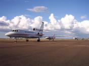
By: 1thobahr

By: 1thobahr


