Login
Register


RQE
Window Rock Airport
Official FAA Data Effective 2026-02-19 0901Z
Chart Supplement

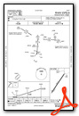
VFR Chart of KRQE
Sectional Charts at SkyVector.com
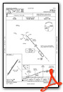
IFR Chart of KRQE
Enroute Charts at SkyVector.com
Location Information for KRQE
Coordinates: N35°39.12' / W109°4.04'Located 01 miles S of Window Rock, Arizona on 88 acres of land. View all Airports in Arizona.
Surveyed Elevation is 6742 feet MSL.
Operations Data
|
|
Airport Communications
| ASOS: | 118.325 Tel. 928-900-4667 |
|---|---|
| UNICOM: | 122.800 |
| CTAF: | 122.800 |
| ASOS at GUP (15.9 SE): | 118.375 505-726-8232 |
| AWOS-3PT at XNI (36.2 S): | 119.275 505-356-2876 |
| AWOS-3PT at GNT (64.0 SE): | 118.3 505-287-9890 |
- APCH/DEP SVC PRVDD BY ALBUQUERQUE ARTCC (ZAB) ON FREQS 124.325/288.25 (ZUNI RCAG).
Nearby Navigation Aids
|
| ||||||||||||||||||||||||||||||

Runway 03/21
RWY 03 TURN AROUND UNUSBL. | ||
| Dimensions: | 7000 x 75 feet / 2134 x 23 meters | |
|---|---|---|
| Surface: | Asphalt in Poor Condition S HALF ROUGH. | |
| Weight Limits: | 15 /F/D/W/T, S-30, D-45, ST-75 | |
| Edge Lighting: | Medium Intensity | |
| Runway 03 | Runway 21 | |
| Coordinates: | N35°38.65' / W109°4.44' | N35°39.60' / W109°3.65' |
| Elevation: | 6701.6 | 6742.0 |
| Traffic Pattern: | Left | Right |
| Runway Heading: | 34° True | 214° True |
| Markings: | Non-Precision Instrument in poor condition. | Non-Precision Instrument in fair condition. |
| Glide Slope Indicator | P2L (3.00° Glide Path Angle) | |
| REIL: | Yes | Yes |
| Obstacles: | 5 ft Fence 202 ft from runway CTLG OBS EXCEEDS 45 DEG SLOPE. +6 FT FENCE 0-200 FT FM THR 125 FT L OF CNTRLN. |
4 FT FENCE 200 FT FM THR BOTH SIDES. |
Services Available
| Fuel: | NONE |
|---|---|
| Transient Storage: | Tiedowns |
| Airframe Repair: | NOT AVAILABLE |
| Engine Repair: | NOT AVAILABLE |
| Bottled Oxygen: | NOT AVAILABLE |
| Bulk Oxygen: | NOT AVAILABLE |
Ownership Information
| Ownership: | Publicly owned | |
|---|---|---|
| Owner: | NAVAJO NATION-C/O NAVAJO DOT | |
| P.O. BOX 4620 | ||
| WINDOW ROCK, AZ 86515 | ||
| 505-371-8320 | ||
| Manager: | KYRON HARDY | |
| P.O. BOX 706 | ||
| WINDOW ROCK, AZ 86515 | ||
| 505-371-8323 | ||
Other Remarks
- THIS AIRPORT HAS BEEN SURVEYED BY THE NATIONAL GEODETIC SURVEY.
- TRRN ALL QUADS.
- FOR CD CTC ALBUQUERQUE ARTCC AT 505-856-4861.
- CTN: TURB INVOF ARPT.
- FADED OR MISG.
- ACTVT REIL RWY 03 & 21; MIRL RWY 03/21 - CTAF.
Weather Minimums


Instrument Approach Procedure (IAP) Charts

Nearby Airports with Instrument Procedures
| ID | Name | Heading / Distance | ||
|---|---|---|---|---|
 |
KGUP | Gallup Municipal Airport | 121° | 16.0 |
|
KGNT | Grants-Milan Municipal Airport | 116° | 64.1 |
|
KSJN | St Johns Industrial Air Park Airport | 192° | 69.6 |
|
KFMN | Four Corners Regional Airport | 031° | 76.9 |
|
KTYL | Taylor Airport | 215° | 88.5 |
|
KINW | Winslow-Lindbergh Regional Airport | 245° | 89.6 |
|
KJTC | Springerville Municipal Airport | 187° | 92.0 |
|
KSOW | Show Low Regional Airport | 209° | 95.1 |
|
KCEZ | Cortez Municipal Airport | 011° | 101.2 |
|
KDRO | Durango-La Plata County Airport | 034° | 110.1 |
|
KAEG | Double Eagle II Airport | 104° | 115.5 |
|
KBDG | Blanding Municipal Airport | 350° | 117.5 |
Airport Images
Do you have a recent image of this airport? Upload it here!


Comments
Airport info errors
I am pilot that works out of RQE. Beacon is not yellow. It is standard green & white.
Comments about Rwy 2 & 20 numbers faded and centerline missing also inaccurate. Runway has new paint so numbers & centerline look good.