Login
Register


RWI
Rocky Mount/Wilson Regional Airport
Official FAA Data Effective 2026-01-22 0901Z
Chart Supplement

VFR Chart of KRWI
Sectional Charts at SkyVector.com
IFR Chart of KRWI
Enroute Charts at SkyVector.com
Location Information for KRWI
Coordinates: N35°51.38' / W77°53.52'Located 07 miles SW of Rocky Mount, North Carolina on 364 acres of land. View all Airports in North Carolina.
Surveyed Elevation is 157 feet MSL.
Operations Data
|
|
Airport Communications
| ASOS: | 118.875 Tel. 252-446-0732 |
|---|---|
| UNICOM: | 123.050 |
| CTAF: | 123.050 |
| AWOS-3P at ETC (17.7 E): | 119.575 252-641-1640 |
| AWOS-3 at LHZ (23.7 NW): | 118.325 919-497-0810 |
| AWOS-3P at GWW (23.8 S): | 118.975 919-731-4473 |
- APCH/DEP SVC PRVDD BY WASHINGTON ARTCC (ZDC) ON 123.85/279.65 (NEW BERN RCAG).
Nearby Navigation Aids
|
| ||||||||||||||||||||||||||||||||||||||||||||||||||||||||||||


Runway 04/22
| Dimensions: | 7099 x 150 feet / 2164 x 46 meters | |
|---|---|---|
| Surface: | Asphalt / Grooved in Good Condition | |
| Weight Limits: | S-101, D-162
PCR VALUE: 600/F/A/W/T
| |
| Edge Lighting: | High Intensity | |
| Runway 04 | Runway 22 | |
| Coordinates: | N35°50.89' / W77°53.91' | N35°51.86' / W77°53.12' |
| Elevation: | 157.7 | 150.3 |
| Traffic Pattern: | Left | Left |
| Runway Heading: | 33° True | 213° True |
| Declared Distances: | TORA:7100 TODA:7100 ASDA:7100 LDA:7100 | TORA:7100 TODA:7100 ASDA:6900 LDA:6900 |
| Markings: | Precision Instrument in good condition. | Precision Instrument in good condition. |
| Glide Slope Indicator | P4L (3.00° Glide Path Angle) | P4L (3.00° Glide Path Angle) |
| Approach Lights: | MALSR 1,400 Foot Medium-intensity Approach Lighting System with runway alignment indicator lights. | |
| REIL: | Yes | |
| Obstacles: | 21 ft Trees 1173 ft from runway, 51 ft right of center | 56 ft Trees 2100 ft from runway |
Services Available
| Fuel: | 100LL (blue), Jet-A |
|---|---|
| Transient Storage: | Hangars,Tiedowns |
| Airframe Repair: | MAJOR |
| Engine Repair: | MAJOR |
| Bottled Oxygen: | NONE |
| Bulk Oxygen: | HIGH |
| Other Services: | AVIONICS,CARGO HANDLING SERVICES,CHARTER SERVICE,PILOT INSTRUCTION,AIRCRAFT RENTAL,AIRCRAFT SALES,ANNUAL SURVEYING |
Ownership Information
| Ownership: | Publicly owned | |
|---|---|---|
| Owner: | ROCKY MOUNT-WILSON ARPT AUTH | |
| 7265 AIR TERMINAL DR | ||
| ELM CITY, NC 27822 | ||
| 252-446-7057 | ||
| Manager: | JOSH PUSSER | |
| 7265 AIR TERMINAL DR | ||
| ELM CITY, NC 27822 | ||
| 252-446-3189 | ALT PHONE NUMBER: 252-469-8817. | |
Other Remarks
- FOR CD IF UNA TO CTC ON FSS FREQ, CTC WASHINGTON ARTCC AT 703-771-3587.
- PAPI RWY 04 & 22 OPR CONSLY. ACTVT MALSR RWY 04; REIL RWY 22; HIRL RWY 04/22 - CTAF.
Weather Minimums

Instrument Approach Procedure (IAP) Charts
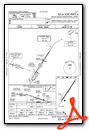

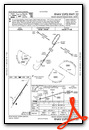
Nearby Airports with Instrument Procedures
| ID | Name | Heading / Distance | ||
|---|---|---|---|---|
 |
W03 | Wilson Industrial Air Center Airport | 216° | 6.4 |
|
KETC | Tarboro-Edgecombe Airport | 073° | 17.5 |
|
KLHZ | Triangle North Exec Airport | 295° | 23.6 |
|
KGWW | Wayne Exec Jetport Airport | 188° | 24.0 |
|
KPGV | Pitt-Greenville Airport | 117° | 28.1 |
|
KJNX | Johnston Regional Airport | 232° | 30.8 |
|
KIXA | Halifax/Northampton Regional Airport | 023° | 31.0 |
|
KGSB | Seymour Johnson AFB Airport | 186° | 31.1 |
|
KISO | Kinston Regional Jetport At Stallings Field Airport | 156° | 34.4 |
|
KMCZ | Martin County Airport | 089° | 34.8 |
|
W40 | Mount Olive Municipal Airport | 190° | 38.7 |
|
KHNZ | Henderson/Oxford Airport | 314° | 43.3 |
Fuel Providers

Airport Images

By: Rocky Mount Wilson


