Login
Register


HIE
Mount Washington Regional Airport
Official FAA Data Effective 2026-02-19 0901Z
Chart Supplement

VFR Chart of KHIE
Sectional Charts at SkyVector.com
IFR Chart of KHIE
Enroute Charts at SkyVector.com
Location Information for KHIE
Coordinates: N44°22.05' / W71°32.75'Located 03 miles E of Whitefield, New Hampshire on 180 acres of land. View all Airports in New Hampshire.
Surveyed Elevation is 1072 feet MSL.
Operations Data
|
|
Airport Communications
| ASOS: | 118.525 Tel. 603-837-2769 |
|---|---|
| UNICOM: | 122.800 |
| CTAF: | 122.800 |
| AWOS-AV at NH08 (19.6 N): | |
| ASOS at BML (20.2 NE): | 135.175 603-449-3328 |
| AWOS-3 at CDA (23.6 NW): | 119.275 802-626-4532 |
- APCH/DEP SVC PRVDD BY BOSTON ARTCC ON FREQS 135.7/282.2(MONTPELIER RCAG).
Nearby Navigation Aids
|
| ||||||||||||||||||||||||||||||||||||||||||||||||||||||||||||


Runway 10/28
| Dimensions: | 4001 x 75 feet / 1220 x 23 meters | |
|---|---|---|
| Surface: | Asphalt in Fair Condition | |
| Weight Limits: | S-30 | |
| Edge Lighting: | Medium Intensity | |
| Runway 10 | Runway 28 | |
| Coordinates: | N44°22.04' / W71°33.21' | N44°22.07' / W71°32.29' |
| Elevation: | 1048.2 | 1072.0 |
| Traffic Pattern: | Left | Right |
| Runway Heading: | 87° True | 267° True |
| Markings: | Non-Precision Instrument in good condition. | Non-Precision Instrument in good condition. |
| Glide Slope Indicator | P4L (3.50° Glide Path Angle) | |
| REIL: | Yes | Yes |
| Obstacles: | 62 ft Trees 791 ft from runway, 257 ft left of center | |
Services Available
| Fuel: | 100LL (blue) |
|---|---|
| Transient Storage: | Tiedowns |
| Airframe Repair: | MAJOR |
| Engine Repair: | MAJOR |
| Bottled Oxygen: | NOT AVAILABLE |
| Bulk Oxygen: | NOT AVAILABLE |
Ownership Information
| Ownership: | Publicly owned | |
|---|---|---|
| Owner: | TOWN OF WHITEFIELD | |
| 56 LITTLETON RD | ||
| WHITEFIELD, NH 03598 | ||
| 603-837-2551 | ||
| Manager: | JAY ENNIS | |
| 56 LITTLETON RD | ||
| WHITEFIELD, NH 03598 | ||
| 603-837-9532 | AMGR CELL: 603-837-9532. EMAIL: MTWASHINGTONREGIONALAIRPORT@GMAIL.COM. | |
Other Remarks
- RWY 28 TRANS LINE ACRS APCH 20:1+, MKD WITH DAY-GLOW BALLS.
- WILDLIFE ON & INVOF ARPT.
- COLD TEMPERATURE AIRPORT. ALTITUDE CORRECTION REQUIRED AT OR BELOW -28C.
- RENTAL CAR AVBL BY REQ, WWW.MOUNTWASHINGTONAIRPORT.COM.
- FOR CD IF UNA TO CTC ON FSS FREQ, CTC BOSTON ARTCC AT 603-879-6859.
- ARPT CONDS NOT RGLRLY MNT.
- RISING TRRN LCTD 3 NM SE OF ARPT.
- 0LL FUEL SELF SVC AVBL 24 HRS WITH CREDIT CARD.
- ACTVT REIL RWYS 10 & 28; PAPI RWY 10; MIRL RWY 10/28 - CTAF.
Weather Minimums

Instrument Approach Procedure (IAP) Charts
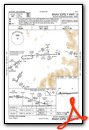
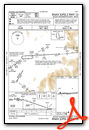
Nearby Airports with Instrument Procedures
| ID | Name | Heading / Distance | ||
|---|---|---|---|---|
 |
KBML | Berlin Regional Airport | 051° | 20.2 |
|
KCDA | Caledonia County Airport | 300° | 23.6 |
|
5B9 | Dean Memorial Airport | 229° | 26.4 |
|
0B1 | Bethel Regional Airport | 083° | 31.8 |
|
KIZG | White Mountain Regional Airport | 130° | 34.3 |
|
KEFK | Northeast Kingdom International Airport | 317° | 42.8 |
|
KMPV | Edward F Knapp State Airport | 257° | 44.9 |
|
KMVL | Morrisville-Stowe State Airport | 282° | 47.0 |
|
81B | Oxford County Regional Airport | 104° | 47.6 |
|
KLCI | Laconia Municipal Airport | 173° | 48.0 |
|
M57 | Rangeley Lake Seaplane Base | 046° | 51.6 |
|
8B0 | Stephen A Bean Municipal Airport | 044° | 53.2 |
Airport Images
Do you have a recent image of this airport? Upload it here!


