Login
Register


MPV
Edward F Knapp State Airport
Official FAA Data Effective 2026-02-19 0901Z
Chart Supplement

VFR Chart of KMPV
Sectional Charts at SkyVector.com
IFR Chart of KMPV
Enroute Charts at SkyVector.com
Location Information for KMPV
Coordinates: N44°12.21' / W72°33.73'Located 03 miles W of Barre/Montpelier, Vermont on 259 acres of land. View all Airports in Vermont.
Surveyed Elevation is 1165 feet MSL.
Operations Data
|
|
Airport Communications
| ASOS: | 132.675 Tel. 802-229-2037 |
|---|---|
| CTAF: | 122.800 |
| UNICOM: | 122.800 |
| ASOS at MVL (19.9 N): | 135.625 802-888-7934 |
| AWOS-AV at VT88 (21.6 SW): | |
| AWOS-3 at 6B0 (26.4 SW): | 118.575 802-388-0255 |
- APCH/DEP SVC PRVDD BY BOSTON ARTCC ON FREQS 135.7/282.2 (MONTPELIER RCAG).
Nearby Navigation Aids
|
| ||||||||||||||||||||||||||||||||||||||||||||||||||||||||||||


Runway 17/35
| Dimensions: | 5000 x 100 feet / 1524 x 30 meters | |
|---|---|---|
| Surface: | Asphalt in Good Condition | |
| Weight Limits: | S-31, D-70 | |
| Edge Lighting: | Medium Intensity | |
| Runway 17 | Runway 35 | |
| Coordinates: | N44°12.40' / W72°34.07' | N44°11.67' / W72°33.52' |
| Elevation: | 1091.5 | 1165.6 |
| Traffic Pattern: | Left | Left |
| Runway Heading: | 152° True | 332° True |
| Displaced Threshold: | 502 Feet | |
| Markings: | Precision Instrument in good condition. | Non-Precision Instrument in good condition. |
| Glide Slope Indicator | P4L (3.00° Glide Path Angle) | |
| Approach Lights: | MALSR 1,400 Foot Medium-intensity Approach Lighting System with runway alignment indicator lights. | |
| REIL: | Yes | |
| Obstacles: | 35 ft Trees 415 ft from runway, 290 ft left of center 52 FT TREE, 1125 FT FM DTHR, 250 FT L, OBSTN CLNC SLP 17:1. CLNC SLP 0:1 TO RWY 17 DTHR DUE TO 6 FT FENCE ON 6 FT HILL, 240 FT LEFT OF CNTRLN. |
14 ft Antenna 262 ft from runway, 197 ft right of center 160 FT TREE, 1200 FT FM DTHR, 140 FT L. OBSTN CLNC SLP 15:1. |
Runway 05/23
| Dimensions: | 3001 x 75 feet / 915 x 23 meters | |
|---|---|---|
| Surface: | Asphalt in Excellent Condition | |
| Weight Limits: | S-30, D-46 | |
| Edge Lighting: | Medium Intensity | |
| Runway 05 | Runway 23 | |
| Coordinates: | N44°12.29' / W72°33.79' | N44°12.71' / W72°33.43' |
| Elevation: | 1115.5 | 1084.7 |
| Traffic Pattern: | Left | Left |
| Runway Heading: | 32° True | 212° True |
| Markings: | Basic in good condition. | Basic in good condition. |
Services Available
| Fuel: | 100LL (blue), Jet A+ |
|---|---|
| Transient Storage: | Tiedowns |
| Airframe Repair: | MAJOR |
| Engine Repair: | MAJOR |
| Bottled Oxygen: | NONE |
| Bulk Oxygen: | NONE |
| Other Services: | AIR FREIGHT SERVICES |
Ownership Information
| Ownership: | Publicly owned | |
|---|---|---|
| Owner: | STATE OF VERMONT | |
| 219 N MAIN ST | ||
| BARRE, VT 05641 | ||
| 802-279-7146 | ||
| Manager: | CHRIS BEITZEL | |
| 219 N MAIN ST | ||
| BARRE, VT 05641 | ||
| 802-272-7725 | ||
Other Remarks
- FLD COND NOT MON WHEN UNATNDD.
- COLD TEMPERATURE AIRPORT. ALTITUDE CORRECTION REQUIRED AT OR BELOW -19C.
- FOR CD IF UNA TO CTC ON FSS FREQ, CTC BOSTON ARTCC AT 603-879-6859 .
- ACTVT MALSR RWY 17; MIRL RWY 17/35 - CTAF.
- UNICOM BASE STN NOT MANNED CONSLY.
Weather Minimums

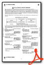
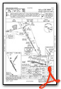
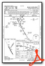
Instrument Approach Procedure (IAP) Charts

Nearby Airports with Instrument Procedures
| ID | Name | Heading / Distance | ||
|---|---|---|---|---|
 |
KMVL | Morrisville-Stowe State Airport | 353° | 20.0 |
|
5B9 | Dean Memorial Airport | 106° | 25.1 |
|
KBTV | Patrick Leahy Burlington International Airport | 302° | 30.1 |
|
KCDA | Caledonia County Airport | 046° | 32.1 |
|
KLEB | Lebanon Municipal Airport | 162° | 36.4 |
|
4B6 | Ticonderoga Municipal Airport | 242° | 41.7 |
|
KEFK | Northeast Kingdom International Airport | 019° | 43.5 |
|
KRUT | Rutland/Southern Vermont Regional Airport | 202° | 43.8 |
|
KHIE | Mount Washington Regional Airport | 076° | 44.9 |
|
KPBG | Plattsburgh International Airport | 304° | 47.3 |
|
KFSO | Franklin County State Airport | 332° | 49.8 |
|
KCNH | Claremont Municipal Airport | 170° | 50.7 |
Airport Images

By: len.emery


