Login
Register


HZL
Hazleton Regional Airport
Official FAA Data Effective 2026-01-22 0901Z
Chart Supplement

VFR Chart of KHZL
Sectional Charts at SkyVector.com
IFR Chart of KHZL
Enroute Charts at SkyVector.com
Location Information for KHZL
Coordinates: N40°59.21' / W75°59.68'Located 02 miles NW of Hazleton, Pennsylvania on 552 acres of land. View all Airports in Pennsylvania.
Surveyed Elevation is 1603 feet MSL.
Operations Data
|
|
Airport Communications
| AWOS-3: | 119.975 Tel. 570-459-4901 |
|---|---|
| WILKES-BARRE APPROACH: | 126.3 256.7 |
| WILKES-BARRE DEPARTURE: | 126.3 256.7 |
| CLEARANCE DELIVERY: | 121.7 ;CTC WILKES BARRE TWR |
| UNICOM: | 123.000 |
| CTAF: | 123.000 |
| AWOS-3PT at 22N (14.8 SE): | 119.350 570-386-3423 |
| AWOS-3 at ZER (24.0 SW): | 127.575 570-544-2778 |
| ASOS at AVP (24.2 NE): | 570-456-5433 |
Nearby Navigation Aids
|
| ||||||||||||||||||||||||||||||||||||||||||||||||||||||||||||


Runway 10/28
| Dimensions: | 5001 x 100 feet / 1524 x 30 meters | |
|---|---|---|
| Surface: | Asphalt / Grooved in Good Condition | |
| Weight Limits: | S-47, D-74 | |
| Edge Lighting: | Medium Intensity | |
| Runway 10 | Runway 28 | |
| Coordinates: | N40°59.24' / W76°0.22' | N40°59.18' / W75°59.14' |
| Elevation: | 1595.5 | 1594.5 |
| Traffic Pattern: | Left | Right VFR DEP PROCEDURE RIGHT TURN HEADING 300 DEGS AT END OF RY. |
| Runway Heading: | 94° True | 274° True |
| Displaced Threshold: | 200 Feet | 103 Feet |
| Declared Distances: | TORA:5001 TODA:5001 ASDA:5001 LDA:4801 | TORA:5001 TODA:5001 ASDA:5001 LDA:4898 |
| Markings: | Non-Precision Instrument in good condition. | Non-Precision Instrument in good condition. |
| Glide Slope Indicator | P4L (3.50° Glide Path Angle) | P4L (3.17° Glide Path Angle) |
| Approach Lights: | MALS 1,400 Foot Medium-intensity Approach Lighting System. | |
| REIL: | Yes | |
| Obstacles: | 221 ft Trees 5426 ft from runway, 183 ft left of center RWY 10 APCH SLP 25:1 TO DTHR. |
45 ft Tree 1111 ft from runway, 97 ft right of center RWY 28 APCH SLP 26:1 TO DTHR. |
Services Available
| Fuel: | 100LL (blue), Jet-A |
|---|---|
| Transient Storage: | Hangars,Tiedowns |
| Airframe Repair: | MINOR |
| Engine Repair: | MINOR |
| Bottled Oxygen: | HIGH |
| Bulk Oxygen: | NONE |
| Other Services: | AIR AMBULANCE SERVICES,CHARTER SERVICE,PARACHUTE JUMP ACTIVITY |
Ownership Information
| Ownership: | Publicly owned | |
|---|---|---|
| Owner: | CITY OF HAZLETON | |
| 40 N CHURCH ST | ||
| HAZLETON, PA 18201 | ||
| (570) 436-6676 | ||
| Manager: | DAVE CHRONOWSKI | |
| 5175 OLD AIRPORT RD | ||
| HAZLE TWP, PA 18202 | ||
| (484) 661-8994 | ||
Other Remarks
- AWOS AVBL 570-459-4901.
- TYPE 1 AND 4 DEICING AVBL.
- JET, TURBOPROP AND CORPORATE AIRCRAFT ONLY.
- 0LL FUEL SVC AFT HRS BY PRIOR REQ 570-468-2479.
- ACTVT MALS RWY 28; REIL RWY 10; PAPI RWY 10; MIRL RWY 10/28 (3,5,7 CLICKS) - CTAF.
Weather Minimums
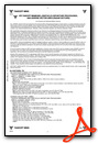

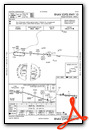
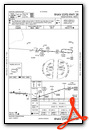
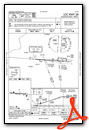
Instrument Approach Procedure (IAP) Charts
Nearby Airports with Instrument Procedures
| ID | Name | Heading / Distance | ||
|---|---|---|---|---|
 |
22N | Jake Arner Memorial Airport | 134° | 15.0 |
|
KWBW | Wilkes-Barre Wyoming Valley Airport | 019° | 19.7 |
|
N13 | Bloomsburg Municipal Airport | 272° | 20.0 |
|
KZER | Schuylkill County/Joe Zerbey Airport | 225° | 24.1 |
|
KAVP | Wilkes-Barre/Scranton International Airport | 030° | 24.4 |
|
N79 | Northumberland County Airport | 250° | 26.9 |
|
KMPO | Pocono Mountains Regional Airport | 071° | 29.3 |
|
8N8 | Danville Airport | 265° | 29.6 |
|
KABE | Lehigh Valley International Airport | 128° | 32.2 |
|
KXLL | Allentown Queen City Municipal Airport | 137° | 34.0 |
|
74N | Bendigo Airport | 225° | 36.3 |
|
KRDG | Reading Regional/Carl A Spaatz Field Airport | 177° | 36.5 |
Airport Images
Do you have a recent image of this airport? Upload it here!


