Login
Register
8N8
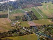
Danville Airport
Official FAA Data Effective 2025-11-27 0901Z
VFR Chart of 8N8
Sectional Charts at SkyVector.com
IFR Chart of 8N8
Enroute Charts at SkyVector.com
Location Information for 8N8
Coordinates: N40°56.90' / W76°38.64'Located 03 miles SW of Danville, Pennsylvania on 73 acres of land. View all Airports in Pennsylvania.
Estimated Elevation is 559 feet MSL.
Operations Data
|
|
Airport Communications
| WILKES-BARRE APPROACH: | 126.3 256.7 |
|---|---|
| WILKES-BARRE DEPARTURE: | 126.3 256.7 |
| CTAF: | 122.800 |
| UNICOM: | 122.800 |
| AWOS-3 at 79PN (2.0 NE): | 118.075 570-271-8192 |
| AWOS-3 at N79 (7.9 SE): | 119.175 570-672-0389 |
| ASOS at SEG (12.6 SW): | 123.975 570-374-4099 |
Nearby Navigation Aids
|
| ||||||||||||||||||||||||||||||||||||||||||||||||
Runway 09/27
| Dimensions: | 3000 x 60 feet / 914 x 18 meters | |
|---|---|---|
| Surface: | Asphalt in Good Condition | |
| Edge Lighting: | Medium Intensity | |
| Runway 09 | Runway 27 | |
| Coordinates: | N40°56.84' / W76°38.95' | N40°56.96' / W76°38.32' |
| Elevation: | 540.7 | 554.1 |
| Markings: | Non-Precision Instrument in fair condition. | Non-Precision Instrument in fair condition. |
| Obstacles: | 50 ft Trees 314 ft from runway, 246 ft right of center | 14 ft Trees 290 ft from runway, 137 ft right of center |
Services Available
| Fuel: | NONE |
|---|---|
| Transient Storage: | Tiedowns |
| Airframe Repair: | MAJOR |
| Engine Repair: | MAJOR |
| Bottled Oxygen: | NONE |
| Bulk Oxygen: | NONE |
Ownership Information
| Ownership: | Publicly owned | |
|---|---|---|
| Owner: | NORTHUMBERLAND & MONTOUR JOINT COMM | |
| 1413 SUNBURY ROAD, ST | ||
| DANVILLE, PA 17821 | ||
| 570-274-6190 | ||
| Manager: | CRAIG LAWLER | |
| 1413 SUNBURY ROAD | ||
| DANVILLE, PA 17824 | ||
| 570-274-6190 | ||
Other Remarks
- DEER & WILDLIFE ON & INVOF ARPT.
- RC AIRPLANE OPS N OF RWY.
- FOR CD CTC WILKES-BARRE APCH AT 570-655-2084.
- LIGHTING NON-STANDARD
- MAIN RAMP NO PROP WASH INVOF MAIN HNGR DUE TO ACFT PAINTING.
- THR LGTS DSPLCD 365 FT FM RWY END FOR NGT DISPLACEMENT. RWY END LGTD WITH TWO RED LGTS ON LEFT SIDE (NON STD).
- ACTVT MIRL RWY 09/27 DRG PERIODS OF DARKNESS ONLY - CTAF.
Weather Minimums
Instrument Approach Procedure (IAP) Charts
Nearby Airports with Instrument Procedures
| ID | Name | Heading / Distance | ||
|---|---|---|---|---|
 |
N79 | Northumberland County Airport | 148° | 7.9 |
 |
N13 | Bloomsburg Municipal Airport | 072° | 9.9 |
 |
KSEG | Penn Valley Airport | 232° | 12.6 |
 |
KZER | Schuylkill County/Joe Zerbey Airport | 139° | 19.0 |
 |
KIPT | Williamsport Regional Airport | 324° | 21.6 |
 |
74N | Bendigo Airport | 170° | 23.7 |
 |
KHZL | Hazleton Regional Airport | 085° | 29.6 |
 |
KLHV | William T Piper Memorial Airport | 287° | 37.1 |
 |
9D4 | Deck Airport | 158° | 38.5 |
 |
58N | Reigle Field Airport | 175° | 39.8 |
 |
P34 | Mifflintown Airport | 239° | 40.6 |
 |
22N | Jake Arner Memorial Airport | 101° | 41.0 |


