Login
Register


IGG
Igiugig Airport
Official FAA Data Effective 2026-01-22 0901Z
Chart Supplement

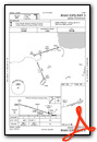
VFR Chart of PAIG
Sectional Charts at SkyVector.com
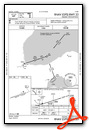
IFR Chart of PAIG
Enroute Charts at SkyVector.com
Location Information for PAIG
Coordinates: N59°19.44' / W155°54.11'Located 00 miles S of Igiugig, Alaska on 117 acres of land. View all Airports in Alaska.
Surveyed Elevation is 90 feet MSL.
Operations Data
|
|
Airport Communications
| AWOS-3P: | 119.925 Tel. 907-533-3350 |
|---|---|
| CTAF: | 122.800 |
| ASOS at ILI (39.6 NE): | 134.95 907-621-7977 |
| ATIS at AKN (45.2 SW): | 128.8 |
| ASOS at AKN (45.2 SW): | 128.8 907-246-7506 |
- APCH/DEP SVC PRVDD BY ANCHORAGE ARTCC ON FREQ 118.8 (ILIAMNA RCAG).
Nearby Navigation Aids
|
| ||||||||||||||||||||||||||||||


Runway 05/23
| Dimensions: | 3000 x 75 feet / 914 x 23 meters | |
|---|---|---|
| Surface: | Gravel-Dirt in Good Condition UP TO 6 INCH DEEP CIRCULAR RUTS NEAR THLD RY 23. | |
| Edge Lighting: | Medium Intensity | |
| Runway 05 | Runway 23 | |
| Coordinates: | N59°19.37' / W155°54.56' | N59°19.52' / W155°53.65' |
| Elevation: | 90.4 | 73.2 |
| Traffic Pattern: | Left | Left |
| Runway Heading: | 72° True | 252° True |
| Obstacles: | 22 ft Trees 0 ft from runway, 120 ft right of center | 3 ft Brush 0 ft from runway, 87 ft right of center |
Services Available
| Fuel: | 100LL (blue) |
|---|---|
| Transient Storage: | NONE |
| Airframe Repair: | NONE |
| Engine Repair: | NONE |
| Bottled Oxygen: | NONE |
| Bulk Oxygen: | NONE |
Ownership Information
| Ownership: | Publicly owned | |
|---|---|---|
| Owner: | ALASKA DOT&PF SOUTHCOAST REGION | |
| PO BOX 112506 | ||
| JUNEAU, AK 99811-2506 | ||
| 907-465-1779 | 907-269-0760 | |
| Manager: | TREFIM ANDREW | CLINT ANELON |
| BOX 187 | ||
| ILIAMNA, AK 99606 | ||
| 907-571-1261 | ||
Other Remarks
- RWY COND NOT MONITORED; RECOMMEND VISUAL INSPECTION PRIOR TO USING.
- WX CAMERA AVBL ON INTERNET AT HTTPS://WEATHERCAMS.FAA.GOV.
- RWY SOFT DURG SPRING BREAKUP & AFTER HVY RAIN.
- SOFT SFC NEAR RWY 23 THLD.
- FUEL SALES AND RESTROOM FAC OFFERED.
- 0LL AVBL 0900-1700L. CTC IGIUGIG VILLAGE COUNCIL AT 907-720-8716 FOR PRICING AND AVAILABILITY AFTER HRS AND HOLIDAYS.
- ACTVT MIRL RY 05/23 & WINDCONE LGTS - CTAF.
- ACTVT ROTG BCN - CTAF.
Weather Minimums


Instrument Approach Procedure (IAP) Charts
Nearby Airports with Instrument Procedures
| ID | Name | Heading / Distance | ||
|---|---|---|---|---|
 |
PFKK | Kokhanok Airport | 078° | 34.4 |
|
PAIL | Iliamna Airport | 048° | 39.7 |
|
PAKN | King Salmon Airport | 211° | 45.3 |
|
PANW | New Stuyahok Airport | 280° | 45.8 |
|
PAJZ | Koliganek Airport | 300° | 48.1 |
|
PFWS | South Naknek Nr 2 Airport | 222° | 50.7 |
|
PANO | Nondalton Airport | 038° | 51.0 |
|
PAKX | Wilder Runway Airport | 041° | 71.1 |
|
PADL | Dillingham Airport | 259° | 82.1 |
|
PAII | Egegik Airport | 214° | 82.5 |
|
PFCL | Clarks Point Airport | 251° | 86.5 |
|
PAPN | Pilot Point Airport | 207° | 117.3 |
Airport Images
Do you have a recent image of this airport? Upload it here!


