Login
Register


WSN
South Naknek Nr 2 Airport
Official FAA Data Effective 2025-11-27 0901Z
Chart Supplement

VFR Chart of PFWS
Sectional Charts at SkyVector.com
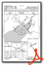
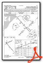
IFR Chart of PFWS
Enroute Charts at SkyVector.com
Location Information for PFWS
Coordinates: N58°42.12' / W157°0.15'Located 01 miles SSW of South Naknek, Alaska on 214 acres of land. View all Airports in Alaska.
Estimated Elevation is 162 feet MSL.
Operations Data
|
|
Airport Communications
| AWOS-3P: | 121.575 Tel. 907-868-7348 |
|---|---|
| CTAF: | 122.900 |
| ATIS at AKN (11.1 E): | 128.8 |
| ASOS at AKN (11.1 E): | 128.8 907-246-7506 |
| AWOS-3P at EII (33.2 S): | 135.65 907-233-2288 |
- APCH CTL PRVDD BY ANCHORAGE ARTCC (ZAN) ON 124.8/354.0 (KING SALMON RCAG).
Nearby Navigation Aids
|
| ||||||||||||||||||||||||


Runway 13/31
| Dimensions: | 3314 x 60 feet / 1010 x 18 meters | |
|---|---|---|
| Surface: | Gravel-Dirt in Fair Condition | |
| Edge Lighting: | High Intensity | |
| Runway 13 | Runway 31 | |
| Coordinates: | N58°42.25' / W157°0.47' | N58°41.84' / W156°59.78' |
| Elevation: | 156.5 | 155.6 |
| Traffic Pattern: | Left | Left |
| Runway Heading: | 139° True | 319° True |
| Displaced Threshold: | 559 Feet | |
| Markings: | Basic in fair condition. | Non-Standard in fair condition. |
| Glide Slope Indicator | V2L (3.00° Glide Path Angle) | |
| Obstacles: | 9 ft Brush 4 ft from runway, 95 ft left of center | 6 ft Brush 0 ft from runway, 72 ft right of center |
Runway 05/23
| Dimensions: | 2264 x 60 feet / 690 x 18 meters | |
|---|---|---|
| Surface: | Gravel-Dirt in Fair Condition | |
| Edge Lighting: | High Intensity | |
| Runway 05 | Runway 23 | |
| Coordinates: | N58°42.16' / W157°0.52' | N58°42.34' / W156°59.89' |
| Elevation: | 162.3 | 128.0 |
| Runway Heading: | 61° True | 241° True |
| Obstacles: | 20 ft Brush 0 ft from runway, 115 ft left of center | 7 ft Brush 0 ft from runway, 71 ft left of center |
Ownership Information
| Ownership: | Publicly owned | |
|---|---|---|
| Owner: | ALASKA DOT&PF SOUTHCOAST REGION | |
| PO BOX 112500 | ||
| JUNEAU, AK 99811-2500 | ||
| 907-465-4512 | ||
| Manager: | FLOYD WILSON | |
| PO BOX 65 | ||
| KING SALMON, AK 99613 | ||
| 907-246-3325 | ||
Other Remarks
- THIS AIRPORT HAS BEEN SURVEYED BY THE NATIONAL GEODETIC SURVEY.
- RWY COND UNMNT; RCMND VISUAL INSP PRIOR TO USE.
- TWY SLPS DOWNHILL TO NW; NO LINE OF SIGHT BTN END OF TWY & RWY 13/31.
- WX CAMERA AVBL ON INTERNET AT HTTPS://WEATHERCAMS.FAA.GOV
- VEHICLES, MOOSE & BEARS ON & INVOF RWYS.
- HVY TFC BTN S NAKNEK & NAKNEK ARPTS LESS THAN 2 MI APART.
- SHORT CONES & LIGHTS.
- ACTVT VASI RWY 13; HIRL RWY 05/23 & 13/31 - CTAF.
Weather Minimums
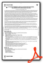
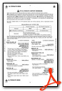
Instrument Approach Procedure (IAP) Charts
Nearby Airports with Instrument Procedures
| ID | Name | Heading / Distance | ||
|---|---|---|---|---|
 |
PAKN | King Salmon Airport | 097° | 11.2 |
|
PAII | Egegik Airport | 200° | 33.2 |
|
PANW | New Stuyahok Airport | 345° | 46.5 |
|
PFCL | Clarks Point Airport | 280° | 48.4 |
|
PAIG | Igiugig Airport | 041° | 50.7 |
|
PADL | Dillingham Airport | 294° | 51.1 |
|
PAMB | Manokotak Airport | 283° | 60.8 |
|
PAJZ | Koliganek Airport | 352° | 62.1 |
|
PAPN | Pilot Point Airport | 195° | 69.8 |
|
PFKK | Kokhanok Airport | 056° | 81.1 |
|
PAIL | Iliamna Airport | 044° | 90.2 |
|
PANO | Nondalton Airport | 039° | 101.6 |
Airport Images
Do you have a recent image of this airport? Upload it here!


