Login
Register


JZZ
Koliganek Airport
Official FAA Data Effective 2026-02-19 0901Z
Chart Supplement

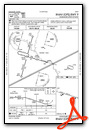
VFR Chart of PAJZ
Sectional Charts at SkyVector.com
IFR Chart of PAJZ
Enroute Charts at SkyVector.com
Location Information for PAJZ
Coordinates: N59°43.61' / W157°15.62'Located 01 miles E of Koliganek, Alaska on 112 acres of land. View all Airports in Alaska.
Surveyed Elevation is 271 feet MSL.
Operations Data
|
|
Airport Communications
| AWOS-3P: | 118.525 Tel. 907-621-7978 |
|---|---|
| CTAF: | 122.900 |
| AWOS-3P at KNW (16.6 S): | 120.275 907-621-7980 |
| AWOS-3P at IGG (47.9 SE): | 119.925 907-533-3350 |
| AWOS-3P at DLG (55.9 SW): | 125.0 907-842-2137 |
- APCH/DEP SVC PRVDD BY ANCHORAGE ARTCC ON FREQS 132.75/282.35 (DILLINGHAM RCAG).
- COMMUNICATIONS PRVDD BY DILLINGHAM FSS ON FREQ 122.55 0745-2345 (KEMUK MOUNTAIN RCO) OTHER TIMES CTC KENAI FSS.
Nearby Navigation Aids
|
| ||||||||||||||||||||||||


Runway 09/27
SLOPES DOWN TOWARD W END. | ||
| Dimensions: | 3300 x 75 feet / 1006 x 23 meters | |
|---|---|---|
| Surface: | Gravel in Good Condition HEAVES & HUMPS; RWY SLOUGHING OFF INTO TUNDRA. | |
| Edge Lighting: | Medium Intensity | |
| Runway 09 | Runway 27 | |
| Coordinates: | N59°43.68' / W157°16.13' | N59°43.53' / W157°15.10' |
| Elevation: | 237.4 | 271.8 |
| Runway Heading: | 106° True | 286° True |
| Declared Distances: | TORA:3300 TODA:3300 ASDA:3300 LDA:3300 | TORA:3300 TODA:3300 ASDA:3300 LDA:3300 |
| Markings: | Non-Standard in good condition. | Non-Standard in good condition. |
| Glide Slope Indicator | P4R (3.50° Glide Path Angle) | P4L (3.50° Glide Path Angle) |
| Obstacles: | 4 ft Brush 5 ft from runway, 217 ft right of center | 6 ft Brush 0 ft from runway, 115 ft right of center |
Services Available
| Fuel: | NONE |
|---|---|
| Transient Storage: | Tiedowns |
| Airframe Repair: | NOT AVAILABLE |
| Engine Repair: | NOT AVAILABLE |
| Bottled Oxygen: | NOT AVAILABLE |
| Bulk Oxygen: | NOT AVAILABLE |
Ownership Information
| Ownership: | Publicly owned | |
|---|---|---|
| Owner: | ALASKA DOT & PF CENTRAL REGION | |
| PO BOX 196900 | ||
| ANCHORAGE, AK 99519-6900 | ||
| 907-269-0749 | ||
| Manager: | KEVIN HARDIN | |
| BOX 250 | ||
| DILLINGHAM, AK 99576 | ||
| 907-842-5511 | ||
Other Remarks
- RWY COND UNMNT; RCMD VISUAL INSP PRIOR TO USE.
- WX CAMERA AVBL ON INTERNET AT HTTPS://WEATHERCAMS.FAA.GOV
- THR MKD WITH LGTS.
- THR MKD WITH LGTS
- ACTVT MIRL RWY 09/27; PAPI RWY 09 & 27 - CTAF.
- ACTVT ROTG BCN - CTAF.
Weather Minimums

Instrument Approach Procedure (IAP) Charts

Nearby Airports with Instrument Procedures
| ID | Name | Heading / Distance | ||
|---|---|---|---|---|
 |
PANW | New Stuyahok Airport | 191° | 16.9 |
|
PAIG | Igiugig Airport | 119° | 48.1 |
|
PADL | Dillingham Airport | 223° | 56.1 |
|
PFWS | South Naknek Nr 2 Airport | 172° | 62.1 |
|
PAKN | King Salmon Airport | 163° | 65.9 |
|
PFCL | Clarks Point Airport | 216° | 66.4 |
|
PAMB | Manokotak Airport | 227° | 69.5 |
|
PAIL | Iliamna Airport | 087° | 71.1 |
|
PANO | Nondalton Airport | 077° | 74.8 |
|
PFKK | Kokhanok Airport | 102° | 77.0 |
|
PAII | Egegik Airport | 182° | 92.8 |
|
PAKX | Wilder Runway Airport | 070° | 93.0 |
Airport Images
Do you have a recent image of this airport? Upload it here!


