Login
Register


IKV
Ankeny Regional Airport
Official FAA Data Effective 2025-12-25 0901Z
Chart Supplement

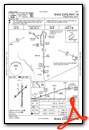
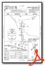
KIKV Airport Diagram

VFR Chart of KIKV
Sectional Charts at SkyVector.com
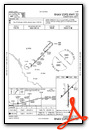
IFR Chart of KIKV
Enroute Charts at SkyVector.com
Location Information for KIKV
Coordinates: N41°41.48' / W93°33.98'Located 01 miles SE of Ankeny, Iowa on 442 acres of land. View all Airports in Iowa.
Surveyed Elevation is 909 feet MSL.
Operations Data
|
|
Airport Communications
| AWOS-3: | 119.175 Tel. 515-965-5764 |
|---|---|
| DES MOINES APPROACH: | 123.9 307.15 |
| DES MOINES DEPARTURE: | 123.9 307.15 |
| CLEARANCE DELIVERY: | 126.65 |
| CTAF: | 122.900 |
| ATIS at DSM (10.4 SW): | 119.55 |
| ASOS at DSM (10.4 SW): | 119.55 515-218-1035 |
| ASOS at AMW (18.2 N): | 132.025 515-233-2611 |
Nearby Navigation Aids
|
| ||||||||||||||||||||||||||||||||||||||||||


Runway 18/36
| Dimensions: | 5500 x 100 feet / 1676 x 30 meters | |
|---|---|---|
| Surface: | Concrete in Fair Condition | |
| Weight Limits: | 12 /R/B/W/U, S-30, D-40 | |
| Edge Lighting: | Medium Intensity | |
| Runway 18 | Runway 36 | |
| Coordinates: | N41°41.86' / W93°33.95' | N41°40.95' / W93°33.95' |
| Elevation: | 903.4 | 887.8 |
| Traffic Pattern: | Left | Right |
| Runway Heading: | 180° True | 360° True |
| Markings: | Non-Precision Instrument in good condition. | Precision Instrument in good condition. |
| Glide Slope Indicator | P2L (3.00° Glide Path Angle) | P2L (3.00° Glide Path Angle) |
| REIL: | Yes | Yes |
| Obstacles: | 49 ft Tree 2025 ft from runway, 144 ft left of center | 20 ft Tree 355 ft from runway, 267 ft right of center 47 FT TREE 177 FT FM TWY END 283 FT R OF CNTRLN, 7:1 APCH SLOPE. |
Runway 04/22
| Dimensions: | 4200 x 75 feet / 1280 x 23 meters | |
|---|---|---|
| Surface: | Concrete in Fair Condition | |
| Weight Limits: | 12 /R/B/W/U, S-30, D-40 | |
| Edge Lighting: | Medium Intensity | |
| Runway 04 | Runway 22 | |
| Coordinates: | N41°41.33' / W93°34.35' | N41°41.82' / W93°33.70' |
| Elevation: | 909.9 | 902.4 |
| Traffic Pattern: | Right | |
| Runway Heading: | 45° True | 225° True |
| Declared Distances: | TORA:4200 TODA:4200 ASDA:4200 LDA:4200 | TORA:4200 TODA:4200 ASDA:4200 LDA:4200 |
| Markings: | Non-Precision Instrument in good condition. | Non-Precision Instrument in good condition. |
| Glide Slope Indicator | P2L (4.00° Glide Path Angle) | P2L (3.00° Glide Path Angle) |
| REIL: | Yes | Yes |
| Obstacles: | 36 ft Road 1200 ft from runway | 60 ft Trees 1178 ft from runway, 146 ft left of center |
Services Available
| Fuel: | 100LL (blue), Jet-A |
|---|---|
| Transient Storage: | Hangars,Tiedowns |
| Airframe Repair: | MAJOR |
| Engine Repair: | MAJOR |
| Bottled Oxygen: | HIGH |
| Bulk Oxygen: | HIGH |
| Other Services: | AVIONICS,CHARTER SERVICE,PILOT INSTRUCTION,AIRCRAFT RENTAL,AIRCRAFT SALES |
Ownership Information
| Ownership: | Publicly owned | |
|---|---|---|
| Owner: | POLK COUNTY AVIATION AUTH | |
| 410 WEST 1ST STREET | ||
| ANKENY, IA 50023 | ||
| 515-965-6400 | ||
| Manager: | PAUL MORITZ | |
| 410 WEST 1ST STREET | ||
| ANKENY, IA 50023 | ||
| 515-965-6428 | ||
Other Remarks
- EXEC 1 AVIATION - (515) 965-1020.
- AMGR REQ USE OF PREFERENTIAL RY 18 WHEN WINDS ARE LESS THAN 5 KNOTS.
- FOR CD CTC DES MOINES ATCT ON 126.65 OR CALL 515-974- 8016.
- ACTVT PAPI RY 4/22; MIRL RWYS 04/22 & 18/36; REIL RWYS 4 & 18/36 - CTAF
- FREQ 122.900 IS ALSO USED AS UNICOM.
Weather Minimums
Instrument Approach Procedure (IAP) Charts

Nearby Airports with Instrument Procedures
| ID | Name | Heading / Distance | ||
|---|---|---|---|---|
 |
KDSM | Des Moines International Airport | 204° | 10.4 |
|
KAMW | Ames Municipal Airport | 352° | 18.2 |
|
KTNU | Newton Municipal-Earl Johnson Field Airport | 092° | 24.5 |
|
KBNW | Boone Municipal Airport | 329° | 24.9 |
|
KPRO | Perry Municipal Airport | 287° | 27.8 |
|
3Y3 | Winterset Municipal Airport | 226° | 28.4 |
|
KOXV | Knoxville Municipal Airport | 138° | 31.1 |
|
KPEA | Pella Municipal Airport | 121° | 32.9 |
|
KGGI | Grinnell Regional Airport | 088° | 37.3 |
|
KMIW | Marshalltown Municipal Airport | 048° | 38.5 |
|
I75 | Osceola Municipal Airport | 188° | 38.7 |
|
KGCT | Guthrie County Regional Airport | 269° | 39.1 |
Airport Images
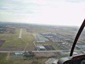
By: Revdevil


