Login
Register


PRO
Perry Municipal Airport
Official FAA Data Effective 2026-01-22 0901Z
Chart Supplement

VFR Chart of KPRO
Sectional Charts at SkyVector.com
IFR Chart of KPRO
Enroute Charts at SkyVector.com
Location Information for KPRO
Coordinates: N41°49.59' / W94°9.57'Located 03 miles W of Perry, Iowa on 138 acres of land. View all Airports in Iowa.
Surveyed Elevation is 1013 feet MSL.
Operations Data
|
|
Airport Communications
| AWOS-3: | 118.0 Tel. 515-465-2269 |
|---|---|
| DES MOINES APPROACH: | 123.9 360.7 |
| DES MOINES DEPARTURE: | 123.9 360.7 |
| CTAF: | 122.800 |
| UNICOM: | 122.800 |
| AWOS-3 at BNW (19.3 NE): | 120.925 515-432-9042 |
| ASOS at AMW (26.0 E): | 132.025 515-233-2611 |
| AWOS-3 at IKV (27.7 E): | 119.175 515-965-5764 |
Nearby Navigation Aids
|
| ||||||||||||||||||||||||||||||||||||||||||||||||


Runway 14/32
| Dimensions: | 5500 x 100 feet / 1676 x 30 meters | |
|---|---|---|
| Surface: | Concrete in Excellent Condition FOD PRODUCING PAVEMENT | |
| Weight Limits: | 15 /R/C/W/U, S-28, D-48 | |
| Edge Lighting: | Medium Intensity | |
| Runway 14 | Runway 32 | |
| Coordinates: | N41°49.91' / W94°9.98' | N41°49.21' / W94°9.22' |
| Elevation: | 1013.0 | 1001.7 |
| Traffic Pattern: | Left | Left |
| Runway Heading: | 141° True | 321° True |
| Markings: | Non-Precision Instrument in good condition. | Non-Precision Instrument in good condition. |
| Glide Slope Indicator | P4L (3.00° Glide Path Angle) | P4L (3.00° Glide Path Angle) |
| REIL: | Yes | Yes |
Runway 04/22
NO SNOW REMOVAL. | ||
| Dimensions: | 2321 x 240 feet / 707 x 73 meters | |
|---|---|---|
| Surface: | Turf in Good Condition | |
| Runway 04 | Runway 22 | |
| Coordinates: | N41°49.54' / W94°9.71' | N41°49.78' / W94°9.31' |
| Elevation: | 1012.7 | 996.7 |
| Traffic Pattern: | Left | Left |
| Runway Heading: | 50° True | 231° True |
Services Available
| Fuel: | 100LL (blue), Jet-A |
|---|---|
| Transient Storage: | Tiedowns |
| Airframe Repair: | MAJOR |
| Engine Repair: | MAJOR |
| Bottled Oxygen: | NONE |
| Bulk Oxygen: | NONE |
Ownership Information
| Ownership: | Publicly owned | |
|---|---|---|
| Owner: | CITY OF PERRY | |
| 1102 WILLIS | ||
| PERRY, IA 50220 | ||
| 515-465-2481 | ||
| Manager: | JACK BUTLER | HARLAN MC GUIRE, CHAIRMAN ARPT COMM, PHONE 515-465-4379. |
| 14381 GALVESTON COURT | ||
| PERRY, IA 50220 | ||
| 515-499-5088 | ||
Other Remarks
- FOR CD CTC DES MOINES ATCT AT 515-974-8016.
- ACTVT MIRL RY 14/32 AND PAPI RYS 14 & 32 AND REIL RYS 14 & 32 - CTAF.
Weather Minimums


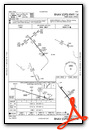
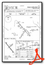
Instrument Approach Procedure (IAP) Charts
Nearby Airports with Instrument Procedures
| ID | Name | Heading / Distance | ||
|---|---|---|---|---|
 |
KEFW | Jefferson Municipal Airport | 323° | 13.7 |
|
KGCT | Guthrie County Regional Airport | 236° | 14.9 |
|
KBNW | Boone Municipal Airport | 046° | 19.3 |
|
KAMW | Ames Municipal Airport | 067° | 26.1 |
|
KIKV | Ankeny Regional Airport | 106° | 27.8 |
|
KDSM | Des Moines International Airport | 127° | 28.4 |
|
3Y3 | Winterset Municipal Airport | 167° | 28.5 |
|
KCIN | Arthur N Neu Airport | 295° | 31.1 |
|
KGFZ | Greenfield Municipal Airport | 203° | 32.6 |
|
KADU | Audubon County Airport | 257° | 35.0 |
|
KEBS | Webster City Municipal Airport | 019° | 38.8 |
|
KFOD | Fort Dodge Regional Airport | 358° | 43.5 |
Airport Images
Do you have a recent image of this airport? Upload it here!


