Login
Register


DSM
Des Moines International Airport
Official FAA Data Effective 2026-01-22 0901Z
From the Flight Deck
Chart Supplement

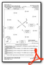
KDSM Airport Diagram

VFR Chart of KDSM
Sectional Charts at SkyVector.com
IFR Chart of KDSM
Enroute Charts at SkyVector.com
Location Information for KDSM
Coordinates: N41°32.04' / W93°39.78'Located 03 miles SW of Des Moines, Iowa on 2625 acres of land. View all Airports in Iowa.
Surveyed Elevation is 957 feet MSL.
Operations Data
|
|
Airport Communications
| ATIS: | 119.55 (515-974-8046) |
|---|---|
| ASOS: | 119.55 Tel. 515-218-1035 |
| DES MOINES TOWER: | 118.3 257.8 |
| DES MOINES GROUND: | 121.9 348.6 |
| DES MOINES APPROACH: | 120.45 123.9 135.2 307.15 350.3 360.7 |
| DES MOINES DEPARTURE: | 120.45 123.9 307.15 350.3 |
| IC: | 118.3 121.9 123.9 257.8 307.15 348.6 |
| CLEARANCE DELIVERY: | 134.15 317.55 |
| UNICOM: | 122.950 |
| CLASS C: | 123.9 307.15 |
| EMERG: | 121.5 243.0 |
| CLASS C/S: | 120.45 135.2 350.3 360.7 |
| AWOS-3 at IKV (10.1 NE): | 119.175 515-965-5764 |
| ASOS at AMW (27.6 N): | 132.025 515-233-2611 |
| AWOS-3 at PRO (28.4 NW): | 118.0 515-465-2269 |
- CTC GND CTL ON 121.9 PRIOR TO PUSHBACK ON THE TRML APN. ADVISE TWR IF DE-ICING IS REQD.
Nearby Navigation Aids
|
| ||||||||||||||||||||||||||||||||||||||||||


Runway 05/23
| Dimensions: | 9004 x 150 feet / 2744 x 46 meters | |
|---|---|---|
| Surface: | Concrete in Excellent Condition | |
| Weight Limits: | S-100, D-190, ST-360, DT-850
PCR VALUE: 696/R/D/W/T
| |
| Edge Lighting: | High Intensity | |
| Runway 05 | Runway 23 | |
| Coordinates: | N41°31.40' / W93°40.63' | N41°32.28' / W93°39.03' |
| Elevation: | 915.5 | 937.0 |
| Traffic Pattern: | Left | Left |
| Runway Heading: | 54° True | 234° True |
| Markings: | Non-Precision Instrument in good condition. | Non-Precision Instrument in good condition. |
| Glide Slope Indicator | P4L (3.00° Glide Path Angle) | P4L (3.00° Glide Path Angle) PAPI UNUSBL BYD 9 DEGS RIGHT OF CNTRLN. |
| RVR Equipment | Touchdown | Rollout |
| Approach Lights: | MALSR 1,400 Foot Medium-intensity Approach Lighting System with runway alignment indicator lights. | |
| REIL: | Yes | Yes |
| Obstacles: | 67 ft Pole 2322 ft from runway, 375 ft left of center | |
Runway 13/31
| Dimensions: | 9001 x 150 feet / 2744 x 46 meters | |
|---|---|---|
| Surface: | Concrete / Grooved in Excellent Condition | |
| Weight Limits: | S-100, D-200, ST-360, DT-850
PCR VALUE: 696/R/D/W/T
| |
| Edge Lighting: | High Intensity | |
| Runway 13 | Runway 31 | |
| Coordinates: | N41°32.74' / W93°40.47' | N41°31.74' / W93°39.01' |
| Elevation: | 912.6 | 957.8 |
| Traffic Pattern: | Left | Right |
| Runway Heading: | 132° True | 312° True |
| Declared Distances: | TORA:9001 TODA:9001 ASDA:9001 LDA:9001 | TORA:9001 TODA:9001 ASDA:9001 LDA:9001 |
| Markings: | Precision Instrument in good condition. | Precision Instrument in good condition. |
| Glide Slope Indicator | P4R (3.00° Glide Path Angle) | P4L (3.00° Glide Path Angle) |
| RVR Equipment | Touchdown Midfield Rollout | Touchdown Midfield Rollout |
| Approach Lights: | MALSR 1,400 Foot Medium-intensity Approach Lighting System with runway alignment indicator lights. | ALSF2 Standard 2,400 Foot High-intensity Approach Lighting System with sequenced flashers, CATEGORY II or III Configuration. |
| Centerline Lights: | Yes | Yes |
Services Available
| Fuel: | 100LL (blue), Jet-A |
|---|---|
| Transient Storage: | Hangars,Tiedowns |
| Airframe Repair: | MAJOR |
| Engine Repair: | MAJOR |
| Bottled Oxygen: | HIGH/LOW |
| Bulk Oxygen: | HIGH/LOW |
| Other Services: | AIR FREIGHT SERVICES,AIR AMBULANCE SERVICES,AVIONICS,CARGO HANDLING SERVICES,CHARTER SERVICE,AIRCRAFT SALES,ANNUAL SURVEYING |
Ownership Information
| Ownership: | Publicly owned | |
|---|---|---|
| Owner: | DES MOINES AIRPORT AUTHORITY | |
| 5800 FLEUR DRIVE, SUITE 207, ROOM 201 | ||
| DES MOINES, IA 50321 | ||
| 515-256-5100 | ||
| Manager: | MR. BRIAN MULCAHY | EXEC DIR |
| 5800 FLEUR DRIVE, SUITE 207 | ||
| DES MOINES, IA 50321-2854 | ||
| 515-256-5100 | ||
Other Remarks
- CONTR FUEL - 515-256-5330.
- BIRDS ON & INVOF ARPT.
- INFORMAL NOISE ABATEMENT PROCEDURES IN EFFECT. EXPECT ATC TO ASSIGN PREFERRED RY.
- IANG SOUTH RAMP PCN 78 R/B/W/T. IANG WEST RAMP PCN 87 R/B/W/T.
- MAX ACFT WT SOUTH GA APRN 170,000 LBS ALL OTHER FBO APRN 80,000 LBS.
- RWY 05 APCH END HAS LTD VIS FROM THE TWR. TWR CANNOT EASILY ID IF AN ACFT IS OVER THE HOLD SHORT LINE AT TWY P7. RWY 05 ARRIVALS - USE CTN AND ENSURE YOU ARE CORRECTLY LINED UP WITH RWY 05 AND NOT TWY P.
- CROSS BLEED ENGINE STARTS ON AIR CARRIER RAMP PROHIBITED.
- USE CAUTION WHEN LNDG OVER RAISED LIGHTS IN THE OVERRUNS AND RWY THLDS AT DSM.
- ARNG RAMP AVBL FOR MIL AND MIL-CONTRACTED ACFT FOR OFFL BUS ONLY WITH LTD SUPPORT. PPR; CTC DSN 261-8360/8361, C515-261-8360/8361. FBO WILL PROVIDE CONTRACT FUEL. MIL CREWS CAN CTC HAWKI ON 252.9
- A321 AIRCRAFT LTD TO 190,000 LBS ON RWY 5-23 AND TWY P. A321 EXCEEDING 190,000 LBS WO ARPT AUTH WAIVER REQ ATCT PRVD 13-31.
- UPDTD: SKED A321 ACFT OVER 200,000 LBS RQR AN OVERWEIGHT ACFT PMT; CTC ARPT AUTH 515-256-5000
- MODERN AVIATION FBO LCTD AT NORTH GA APRON.
- TERMINAL APRON TAXILANE ADG III AC ONLY, ADG IV AC AT GATE A4 ONLY.
- TRML APRON TAXILANE ADG III (ACFT WINGSPAN LESS THAN 118 FT) ONLY, ADG IV (ACFT WINGSPAN LESS THAN 172 FT) ACFT AT GATE A4 ONLY.
- TERMINAL APRON DE-ICE SPOT N2 AND ASSOCIATED TAXILANE LIMITED TO ADGII UNLESS COORDINATED WITH IDS 129.875.
Weather Minimums


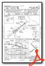
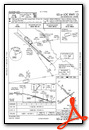
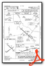
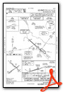
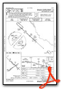
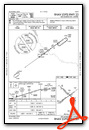
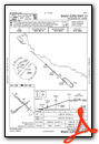
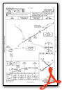
Instrument Approach Procedure (IAP) Charts


Departure Procedure (DP) Charts
Nearby Airports with Instrument Procedures
| ID | Name | Heading / Distance | ||
|---|---|---|---|---|
 |
KIKV | Ankeny Regional Airport | 024° | 10.4 |
|
3Y3 | Winterset Municipal Airport | 237° | 19.1 |
|
KAMW | Ames Municipal Airport | 003° | 27.5 |
|
KPRO | Perry Municipal Airport | 308° | 28.4 |
|
KOXV | Knoxville Municipal Airport | 119° | 28.5 |
|
I75 | Osceola Municipal Airport | 182° | 28.9 |
|
KTNU | Newton Municipal-Earl Johnson Field Airport | 073° | 30.1 |
|
KBNW | Boone Municipal Airport | 345° | 32.0 |
|
KPEA | Pella Municipal Airport | 103° | 33.3 |
|
KCNC | Chariton Municipal Airport | 155° | 33.8 |
|
KGCT | Guthrie County Regional Airport | 285° | 35.9 |
|
KGFZ | Greenfield Municipal Airport | 250° | 37.4 |
Fuel Providers

Airport Images

By: Big Orange Bird


