Login
Register


JMS
Jamestown Regional Airport
Official FAA Data Effective 2026-02-19 0901Z
Chart Supplement

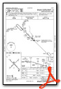
KJMS Airport Diagram

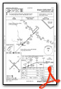
VFR Chart of KJMS
Sectional Charts at SkyVector.com
IFR Chart of KJMS
Enroute Charts at SkyVector.com
Location Information for KJMS
Coordinates: N46°55.78' / W98°40.69'Located 02 miles NE of Jamestown, North Dakota on 1500 acres of land. View all Airports in North Dakota.
Surveyed Elevation is 1499 feet MSL.
Operations Data
|
|
Airport Communications
| ASOS: | 118.425 Tel. 701-251-9002 |
|---|---|
| CTAF: | 123.000 |
| UNICOM: | 123.000 |
| AWOS-3 at BAC (27.1 E): | 118.725 701-845-9117 |
| AWOS-3 at 46D (36.8 NW): | 118.575 701-652-1875 |
| AWOS-3 at S32 (37.7 NE): | 118.750 701-797-2566 |
- APCH/DEP SVC PRVDD BY MINNEAPOLIS ARTCC ON FREQS 124.2/270.3 (WOODWORTH RCAG).
- COMMUNICATIONS PRVDD BY GRAND FORKS RADIO ON FREQ 122.2 (JAMESTOWN RCO).
Nearby Navigation Aids
|
| ||||||||||||||||||||||||||||||||||||||||||


Runway 13/31
| Dimensions: | 6502 x 100 feet / 1982 x 30 meters | |
|---|---|---|
| Surface: | Asphalt / Grooved in Good Condition | |
| Weight Limits: | S-130, D-160, ST-250
PCR VALUE: 490/F/C/X/T
| |
| Edge Lighting: | High Intensity | |
| Runway 13 | Runway 31 | |
| Coordinates: | N46°56.14' / W98°41.23' | N46°55.39' / W98°40.12' |
| Elevation: | 1499.8 | 1496.9 |
| Traffic Pattern: | Left | Left |
| Runway Heading: | 135° True | 315° True |
| Declared Distances: | TORA:6502 TODA:6502 ASDA:6502 LDA:6502 | TORA:6502 TODA:6502 ASDA:6502 LDA:6502 |
| Markings: | Non-Precision Instrument in good condition. | Precision Instrument in good condition. |
| Glide Slope Indicator | P4L (3.00° Glide Path Angle) | P4L (3.00° Glide Path Angle) |
| Approach Lights: | MALSR 1,400 Foot Medium-intensity Approach Lighting System with runway alignment indicator lights. | |
| REIL: | Yes | |
| Obstacles: | 46 ft Tree 1927 ft from runway, 70 ft right of center | |
Runway 04/22
| Dimensions: | 5750 x 75 feet / 1753 x 23 meters | |
|---|---|---|
| Surface: | Asphalt in Fair Condition | |
| Weight Limits: | S-85, D-103, ST-162
PCR VALUE: 80/F/D/X/T
| |
| Edge Lighting: | Medium Intensity | |
| Runway 04 | Runway 22 | |
| Coordinates: | N46°55.47' / W98°41.20' | N46°56.14' / W98°40.23' |
| Elevation: | 1493.8 | 1499.6 |
| Traffic Pattern: | Left | Left |
| Runway Heading: | 45° True | 225° True |
| Declared Distances: | TORA:5750 TODA:5750 ASDA:5750 LDA:5750 | TORA:5750 TODA:5750 ASDA:5750 LDA:5750 |
| Markings: | Non-Precision Instrument in good condition. | Non-Precision Instrument in good condition. |
| Glide Slope Indicator | P4L (3.00° Glide Path Angle) | P4L (3.00° Glide Path Angle) |
| REIL: | Yes | Yes |
Services Available
| Fuel: | 100LL (blue), Jet-A |
|---|---|
| Transient Storage: | Hangars,Tiedowns |
| Airframe Repair: | MAJOR |
| Engine Repair: | MAJOR |
| Bottled Oxygen: | HIGH |
| Bulk Oxygen: | NOT AVAILABLE |
| Other Services: | CROP DUSTING SERVICES,AIR AMBULANCE SERVICES,CHARTER SERVICE,PILOT INSTRUCTION,AIRCRAFT RENTAL,AIRCRAFT SALES,ANNUAL SURVEYING |
Ownership Information
| Ownership: | Publicly owned | |
|---|---|---|
| Owner: | JAMESTOWN RGNL ARPT AUTHORITY | |
| PO BOX 1560 | ||
| JAMESTOWN, ND 58402 | ||
| 701-252-6466 | ||
| Manager: | KATIE HEMMER | |
| PO BOX 1560 | ||
| JAMESTOWN, ND 58402 | ||
| 701-252-6466 | ||
Other Remarks
- THIS AIRPORT HAS BEEN SURVEYED BY THE NATIONAL GEODETIC SURVEY.
- BIRDS ON AND INVOF ARPT.
- FBO FUELING AFTER HOURS PHONE 701-952-1515.
- FOR CD IF UNA TO CTC ON FSS FREQ, CTC MINNEAPOLIS ARTCC AT 651-463-5588.
- INDEX B ARFF AVAILABLE, 48 HRS PPR CONTACT AIRPORT MANAGER 701-252-6466.
- 0LL 100LL AVBL 24 HRS WITH CREDIT CARD. 24 HR PILOT LOUNGE AVBL.
- ACTVT MALSR RWY 31; REIL RWYS 04, 13, & 22; MIRL RWY 04/22; HIRL RWY 13/31 - CTAF. PAPI RWYS 04, 13, 22, & 31 OPR CONSLY.
Weather Minimums


Instrument Approach Procedure (IAP) Charts


Nearby Airports with Instrument Procedures
| ID | Name | Heading / Distance | ||
|---|---|---|---|---|
 |
KBAC | Barnes County Municipal Airport | 088° | 27.2 |
|
51D | Edgeley Municipal Airport | 183° | 34.9 |
|
46D | Carrington Municipal Airport | 328° | 36.8 |
|
S32 | Cooperstown Municipal Airport | 038° | 37.7 |
|
6L3 | Lisbon Municipal Airport | 126° | 48.8 |
|
2D5 | Oakes Municipal Airport | 151° | 51.7 |
|
4E7 | Ellendale Municipal Airport | 172° | 55.2 |
|
KGWR | Gwinner/Roger Melroe Field Airport | 134° | 60.5 |
|
5N8 | Casselton Robert Miller Regional Airport | 093° | 60.7 |
|
4V4 | Northwood Municipal/Vince Field Airport | 042° | 65.2 |
|
5L0 | Lakota Municipal Airport | 012° | 67.5 |
|
3H4 | Hillsboro Municipal Airport | 068° | 71.1 |
Airport Images

By: winglet714

By: winglet714


