Login
Register


BAC
Barnes County Municipal Airport
Official FAA Data Effective 2026-02-19 0901Z
Chart Supplement

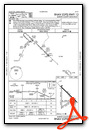
VFR Chart of KBAC
Sectional Charts at SkyVector.com
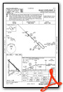
IFR Chart of KBAC
Enroute Charts at SkyVector.com
Location Information for KBAC
Coordinates: N46°56.47' / W98°1.08'Located 01 miles NW of Valley City, North Dakota on 330 acres of land. View all Airports in North Dakota.
Surveyed Elevation is 1401 feet MSL.
Operations Data
|
|
Airport Communications
| AWOS-3: | 118.725 Tel. 701-845-9117 |
|---|---|
| UNICOM: | 122.800 |
| CTAF: | 122.800 |
| ASOS at JMS (27.1 W): | 118.425 701-251-9002 |
| AWOS-3 at S32 (29.1 N): | 118.750 701-797-2566 |
| AWOS-3 at GWR (46.1 S): | 118.325 701-678-6801 |
- APCH/DEP SVC PRVDD BY MINNEAPOLIS ARTCC ON FREQS 124.2/270.3 (WOODWORTH RCAG).
Nearby Navigation Aids
|
| ||||||||||||||||||||||||||||||||||||||||||||||||


Runway 13/31
| Dimensions: | 4201 x 75 feet / 1280 x 23 meters | |
|---|---|---|
| Surface: | Concrete in Good Condition | |
| Weight Limits: | S-12 | |
| Edge Lighting: | Medium Intensity | |
| Runway 13 | Runway 31 | |
| Coordinates: | N46°56.84' / W98°1.35' | N46°56.36' / W98°0.62' |
| Elevation: | 1401.7 | 1384.9 |
| Traffic Pattern: | Left | Left |
| Runway Heading: | 134° True | 314° True |
| Markings: | Non-Precision Instrument in good condition. | Non-Precision Instrument in good condition. |
| Glide Slope Indicator | P2L (3.00° Glide Path Angle) | P2L (3.00° Glide Path Angle) |
Runway 17/35
| Dimensions: | 3539 x 100 feet / 1079 x 30 meters | |
|---|---|---|
| Surface: | Turf in Good Condition | |
| Runway 17 | Runway 35 | |
| Coordinates: | N46°56.78' / W98°1.30' | N46°56.20' / W98°1.30' |
| Elevation: | 1397.0 | 1380.1 |
| Traffic Pattern: | Left | Left |
| Runway Heading: | 180° True | 360° True |
Runway 05/23
| Dimensions: | 2525 x 120 feet / 770 x 37 meters | |
|---|---|---|
| Surface: | Turf in Good Condition | |
| Runway 05 | Runway 23 | |
| Coordinates: | N46°56.22' / W98°1.27' | N46°56.44' / W98°0.76' |
| Elevation: | 1379.3 | 1384.8 |
| Traffic Pattern: | Left | Left |
| Runway Heading: | 58° True | 238° True |
Runway 08/26
| Dimensions: | 2520 x 120 feet / 768 x 37 meters | |
|---|---|---|
| Surface: | Turf in Good Condition | |
| Runway 08 | Runway 26 | |
| Coordinates: | N46°56.38' / W98°1.28' | N46°56.37' / W98°0.67' |
| Elevation: | 1385.5 | 1384.2 |
| Traffic Pattern: | Left | Left |
| Runway Heading: | 90° True | 270° True |
Services Available
| Fuel: | 100LL (blue), Jet-A |
|---|---|
| Transient Storage: | Hangars,Tiedowns |
| Airframe Repair: | MAJOR |
| Engine Repair: | MAJOR |
| Bottled Oxygen: | NONE |
| Bulk Oxygen: | NONE |
| Other Services: | CROP DUSTING SERVICES,AIR AMBULANCE SERVICES,AVIONICS,CHARTER SERVICE,PILOT INSTRUCTION,AIRCRAFT RENTAL,AIRCRAFT SALES FOR ARPT SVCS CTC 701-845-2100. |
Ownership Information
| Ownership: | Publicly owned | |
|---|---|---|
| Owner: | BARNES COUNTY AIRPORT AUTHORITY | |
| P.O. BOX 2 | ||
| VALLEY CITY, ND 58072 | ||
| 701-840-2029 | ARPT AUTH CHAIRPERSON - SHAWN ANDERSON. | |
| Manager: | MIKE LERUD | |
| P.O. BOX 2 | ||
| VALLEY CITY, ND 58072 | ||
| 701-840-5903 | ||
Other Remarks
- RWY 05/23, 08/26 & 17/35 CLSD WINTER MONTHS DUE TO LACK OF SNOW REMOVAL
- CONFIRM SNOW REMOVAL & WINTER CONDS NOV-MAR, CALL 701-840-5903.
- BIRDS & DEER ON & INVOF ARPT.
- FOR CD CTC MINNEAPOLIS ARTCC AT 651-463-5588.
- GLD ACT ON & INVOF ARPT.
- 0LL FUEL AVBL H24 SELF SVC VIA CREDIT CARD.
- FUEL AVBL H24 SELF SVC VIA CREDIT CARD.
- MIRL RWY 13/31 PRESET ON MED INTST; TO INCR INTST AND ACTVT PAPI RWY 13 & 31 - CTAF.
Weather Minimums


Instrument Approach Procedure (IAP) Charts
Nearby Airports with Instrument Procedures
| ID | Name | Heading / Distance | ||
|---|---|---|---|---|
 |
KJMS | Jamestown Regional Airport | 268° | 27.2 |
|
S32 | Cooperstown Municipal Airport | 352° | 29.1 |
|
6L3 | Lisbon Municipal Airport | 157° | 32.0 |
|
5N8 | Casselton Robert Miller Regional Airport | 098° | 33.7 |
|
K74 | Robert Odegaard Field Airport | 112° | 45.5 |
|
KGWR | Gwinner/Roger Melroe Field Airport | 160° | 46.1 |
|
2D5 | Oakes Municipal Airport | 183° | 46.2 |
|
51D | Edgeley Municipal Airport | 220° | 46.3 |
|
3H4 | Hillsboro Municipal Airport | 057° | 46.6 |
|
KFAR | Hector International Airport | 090° | 49.4 |
|
4V4 | Northwood Municipal/Vince Field Airport | 020° | 50.2 |
|
46D | Carrington Municipal Airport | 303° | 55.6 |
Airport Images

By: winglet714

By: winglet714


