Login
Register


JRO
James A Rhodes Airport
Official FAA Data Effective 2026-01-22 0901Z
Chart Supplement

VFR Chart of KJRO
Sectional Charts at SkyVector.com
IFR Chart of KJRO
Enroute Charts at SkyVector.com
Location Information for KJRO
Coordinates: N38°58.88' / W82°34.67'Located 05 miles SE of Jackson, Ohio on 180 acres of land. View all Airports in Ohio.
Surveyed Elevation is 726 feet MSL.
Operations Data
|
|
Airport Communications
| AWOS-3PT: | 118.825 Tel. 740-286-1760 |
|---|---|
| HUNTINGTON APPROACH: | 128.4 270.1 |
| HUNTINGTON DEPARTURE: | 128.4 270.1 |
| CTAF: | 122.700 |
| UNICOM: | 122.700 |
| AWOS-3PT at PMH (15.3 SW): | 125.175 740-820-2500 |
| AWOS-3PT at EOP (19.9 NW): | 121.45 740-947-0035 |
| AWOS-3PT at GAS (21.3 SE): | 119.925 740-446-2149 |
Nearby Navigation Aids
|
| ||||||||||||||||||||||||||||||||||||||||||||||||||||||||||||


Runway 01/19
| Dimensions: | 5201 x 75 feet / 1585 x 23 meters | |
|---|---|---|
| Surface: | Asphalt in Excellent Condition | |
| Edge Lighting: | Medium Intensity | |
| Runway 01 | Runway 19 | |
| Coordinates: | N38°58.45' / W82°34.72' | N38°59.31' / W82°34.62' |
| Elevation: | 722.5 | 726.2 |
| Traffic Pattern: | Left | Left |
| Runway Heading: | 5° True | 185° True |
| Displaced Threshold: | 331 Feet | |
| Markings: | Non-Precision Instrument in good condition. | Non-Precision Instrument in good condition. |
| Glide Slope Indicator | P4R (4.00° Glide Path Angle) PAPI UNUSBL BYD 9 DEGS LEFT OF CNTRLN. | P4L (4.00° Glide Path Angle) PAPI UNUSBL BYD 7 DEGS RIGHT OF CNTRLN. |
| Obstacles: | 75 ft Tree 919 ft from runway, 175 ft right of center APCH RATIO 15:1 TO DTHR. |
15 ft Road 201 ft from runway, 230 ft right of center 15 FT ROAD, 0-200 FT DIST, 230 FT R. |
Services Available
| Fuel: | 100LL (blue), Jet A-1+ |
|---|---|
| Transient Storage: | Tiedowns |
| Airframe Repair: | MAJOR |
| Engine Repair: | MAJOR |
| Bottled Oxygen: | NONE |
| Bulk Oxygen: | NONE |
| Other Services: | PILOT INSTRUCTION,AIRCRAFT RENTAL |
Ownership Information
| Ownership: | Publicly owned | |
|---|---|---|
| Owner: | JACKSON CO COMM | |
| 25 E SOUTH ST, PO BOX 606 | ||
| JACKSON, OH 45640-0606 | ||
| 740-286-0137 | ||
| Manager: | DON LEWIS | |
| 1800 KEYSTONE STATION RD | ||
| JACKSON, OH 45640-8701 | ||
| 740-286-0137 | ||
Other Remarks
- FOR CD CTC HUNTINGTON ATCT AT 304-453-2490.
- 0LL 100LL & JET A1+ AVBL H24 SELF SVC VIA CREDIT CARD.
- ACTVT MIRL RWY 01/19 - CTAF. PAPI RWY 01 & 19 OPR CONSLY.
Weather Minimums


Instrument Approach Procedure (IAP) Charts
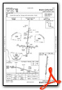
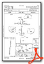
Nearby Airports with Instrument Procedures
| ID | Name | Heading / Distance | ||
|---|---|---|---|---|
 |
KPMH | Greater Portsmouth Regional Airport | 236° | 15.2 |
|
KEOP | Pike County Airport | 304° | 19.8 |
|
KGAS | Gallia-Meigs Regional Airport | 114° | 21.3 |
|
KUNI | Ohio University Airport | 049° | 21.4 |
|
3I2 | Mason County Airport | 099° | 22.8 |
|
KDWU | Ashland Regional Airport | 196° | 26.7 |
|
KRZT | Ross County Airport | 323° | 34.5 |
|
I18 | Jackson County Airport | 094° | 35.6 |
|
KHTS | Tri-State/Milton J Ferguson Field Airport | 178° | 36.7 |
|
12V | Ona Airpark Airport | 151° | 36.9 |
|
KCYO | Pickaway County Memorial Airport | 329° | 37.2 |
|
I86 | Ed Newlon Field Airport | 022° | 46.1 |
Airport Images
Do you have a recent image of this airport? Upload it here!


