Login
Register


HTS
Tri-State/Milton J Ferguson Field Airport
Official FAA Data Effective 2026-01-22 0901Z
Chart Supplement

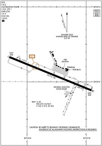
KHTS Airport Diagram
VFR Chart of KHTS
Sectional Charts at SkyVector.com
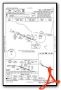
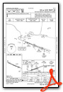
IFR Chart of KHTS
Enroute Charts at SkyVector.com
Location Information for KHTS
Coordinates: N38°22.11' / W82°33.62'Located 03 miles S of Huntington, West Virginia on 1300 acres of land. View all Airports in West Virginia.
Surveyed Elevation is 828 feet MSL.
Operations Data
|
|
Airport Communications
| ATIS: | 125.2 |
|---|---|
| ASOS: | Tel. 681-432-1499 |
| HUNTINGTON TOWER: | 118.5 270.1 |
| HUNTINGTON GROUND: | 121.9 |
| HUNTINGTON APPROACH: | 119.75 ;SOUTH 128.4 ;NORTH 270.1 |
| HUNTINGTON DEPARTURE: | 119.75 ;SOUTH 128.4 ;NORTH 270.1 |
| IC: | 119.75 ;SOUTH |
| CLEARANCE DELIVERY: | 118.05 |
| UNICOM: | 122.950 |
| TRSA: | 119.75 ;SOUTH 128.4 ;NORTH 270.1 |
| EMERG: | 121.5 243.0 |
| AWOS-3PT at DWU (13.9 NW): | 132.425 606-836-2682 |
| AWOS-3PT at PMH (31.3 NW): | 125.175 740-820-2500 |
| AWOS-3PT at GAS (33.6 NE): | 119.925 740-446-2149 |
Nearby Navigation Aids
|
| ||||||||||||||||||||||||||||||||||||||||||||||||||||||||||||


Runway 12/30
| Dimensions: | 7017 x 150 feet / 2139 x 46 meters | |
|---|---|---|
| Surface: | Asphalt / Grooved in Good Condition | |
| Weight Limits: | S-120, D-210, ST-394
PCR VALUE: 470/F/A/W/T
| |
| Edge Lighting: | High Intensity | |
| Runway 12 | Runway 30 | |
| Coordinates: | N38°22.33' / W82°34.30' | N38°21.89' / W82°32.94' |
| Elevation: | 827.9 | 828.1 |
| Traffic Pattern: | Left | Left |
| Runway Heading: | 112° True | 292° True |
| Displaced Threshold: | 501 Feet | |
| Declared Distances: | TORA:7017 TODA:7017 ASDA:6516 LDA:6516 | TORA:7017 TODA:7017 ASDA:7017 LDA:6516 |
| Markings: | Precision Instrument in good condition. | Precision Instrument in good condition. |
| Glide Slope Indicator | P4L (3.00° Glide Path Angle) | P4L (3.00° Glide Path Angle) RY 30 P4L UNUSBL BYD 7 DEGS LEFT OF CNTRLN. |
| RVR Equipment | Touchdown | Rollout |
| Approach Lights: | MALSR 1,400 Foot Medium-intensity Approach Lighting System with runway alignment indicator lights. | |
| REIL: | Yes | |
| Obstacles: | 36 ft Trees 950 ft from runway, 400 ft left of center | |
Services Available
| Fuel: | 100LL (blue), Jet-A |
|---|---|
| Transient Storage: | Hangars,Tiedowns |
| Airframe Repair: | MAJOR |
| Engine Repair: | MAJOR |
| Bottled Oxygen: | HIGH/LOW |
| Bulk Oxygen: | NONE |
| Other Services: | CARGO HANDLING SERVICES,CHARTER SERVICE,PILOT INSTRUCTION,AIRCRAFT SALES |
Ownership Information
| Ownership: | Publicly owned | |
|---|---|---|
| Owner: | TRI-STATE AIRPORT AUTH. | |
| 1449 AIRPORT ROAD | ||
| HUNTINGTON, WV 25704 | ||
| 304-453-6165 | ||
| Manager: | BRENT BROWN | |
| 1449 AIRPORT ROAD | ||
| HUNTINGTON, WV 25704 | ||
| 304-453-6165 | ||
Other Remarks
- PILOTS REPORT POSSIBILITY OF MISTAKING FUEL BURNING STACK LCTD APRXLY 2 MI W RY 12 FOR APCH LGTG SFL.
- RY 12 OBSTN TWR LCTD 5100 FT W 600 FT N END RY.
- BIRDS & DEER ON & INVOF ARPT.
Weather Minimums

Instrument Approach Procedure (IAP) Charts


Nearby Airports with Instrument Procedures
| ID | Name | Heading / Distance | ||
|---|---|---|---|---|
 |
KDWU | Ashland Regional Airport | 323° | 13.9 |
|
12V | Ona Airpark Airport | 075° | 17.5 |
|
KPMH | Greater Portsmouth Regional Airport | 334° | 31.3 |
|
KGAS | Gallia-Meigs Regional Airport | 033° | 33.6 |
|
KJRO | James A Rhodes Airport | 358° | 36.7 |
|
KSJS | Big Sandy Regional Airport | 185° | 37.2 |
|
3I2 | Mason County Airport | 033° | 39.3 |
|
6L4 | Logan County Airport | 135° | 43.3 |
|
KCRW | West Virginia International Yeager Airport | 089° | 45.7 |
|
KEBD | Southern West Virginia Regional Airport | 153° | 46.1 |
|
I18 | Jackson County Airport | 045° | 48.4 |
|
KPBX | Pike County/Hatcher Field Airport | 180° | 48.3 |
Airport Images
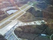
By: jderosa


