Login
Register


K09
Piseco Airport
Official FAA Data Effective 2026-01-22 0901Z
Chart Supplement

VFR Chart of K09
Sectional Charts at SkyVector.com
IFR Chart of K09
Enroute Charts at SkyVector.com
Location Information for K09
Coordinates: N43°27.20' / W74°30.90'Located 01 miles N of Piseco, New York on 60 acres of land. View all Airports in New York.
Surveyed Elevation is 1703 feet MSL.
Operations Data
|
|
Airport Communications
| UNICOM: | 122.800 |
|---|---|
| CTAF: | 122.800 |
| AWOS-3 at NY0 (28.5 S): | 119.225 518-762-0322 |
| AWOS-3 at 5B2 (37.5 SE): | 132.025 518-884-9289 |
| ASOS at GFL (40.1 E): | 119.925 518-743-1728 |
- APCH/DEP SVC PRVDD BY BOSTON ARTCC ON FREQS 135.25/377.1 (TURIN RCAG).
Nearby Navigation Aids
|
| ||||||||||||||||||||||||||||||||||||||||||||||||||||||||||||


Runway 04/22
| Dimensions: | 3016 x 60 feet / 919 x 18 meters | |
|---|---|---|
| Surface: | Asphalt in Good Condition | |
| Weight Limits: | S-8 | |
| Edge Lighting: | Medium Intensity | |
| Runway 04 | Runway 22 | |
| Coordinates: | N43°26.98' / W74°31.07' | N43°27.41' / W74°30.73' |
| Elevation: | 1694.0 | 1702.9 |
| Traffic Pattern: | Right | |
| Runway Heading: | 31° True | 211° True |
| Markings: | Non-Precision Instrument in good condition. | Basic in good condition. |
| Glide Slope Indicator | P2L (3.80° Glide Path Angle) RWY 04 PAPI UNUSBL 9 DEG RIGHT OF CTRLN. | |
| REIL: | Yes | Yes |
| Obstacles: | 52 ft Trees 450 ft from runway, 144 ft right of center ROADS PARALLEL TO RWY 124 FT LT AND 215 FT RT. |
92 ft Trees 562 ft from runway, 201 ft right of center RWY 22 +80 FT TREES, 0-200 FT FROM RWY, 243 FT LT AND RT OF CENTERLINE. |
Helipad H1
| Dimensions: | 40 x 40 feet / 12 x 12 meters | |
|---|---|---|
| Surface: | Asphalt in Good Condition | |
| Edge Lighting: | Perimeter | |
| Coordinates: | N43°26.99' / W74°31.01' | N0°0.00' / E0°0.00' |
| Elevation: | 1694.0 | |
| Approach Lights: | RLLS RLLS | |
Services Available
| Fuel: | 100LL (blue) |
|---|---|
| Transient Storage: | Hangars,Tiedowns |
| Airframe Repair: | NONE |
| Engine Repair: | NONE |
| Bottled Oxygen: | NONE |
| Bulk Oxygen: | NONE |
Ownership Information
| Ownership: | Publicly owned | |
|---|---|---|
| Owner: | TOWN OF ARIETTA | |
| PO BOX 37 | ||
| PISECO LAKE, NY 12139 | ||
| 518-548-3415 | ||
| Manager: | TOWN OF ARIETTA | |
| BOX 37 | ||
| PISECO LAKE, NY 12139 | ||
| 518-548-3415 | AFT HRS CALL 518-571-6066. | |
Other Remarks
- CTN-MODERATE TURBULANCE IN APCH TO RWY 22.
- FOR CD CTC SYRACUSE APCH AT 315-455-6218.
- SEAGULLS - DEER - BEARS OCCASIONALLY VCNTY OF RWY DURING SUMMER MONTHS.
- ACFT DEPARTING RWY 22 ARE REQUESTED TO MAINTAIN RWY HEADING UNTIL PAST ISLAND CHECKPOINT, PRIOR TO MAKING LEFT TURN. ACFT ARRIVING MAINTAIN RGT DOWNWIND HEADING UNTIL PAST ISLAND CHECKPOINT.
- TWYS HAVE REFLECTIVE MARKERS.
- EXPECT TURBULENCE & DOWNDRAFTS DURG PERIODS OF STRONG CROSSWINDS.
- AREA NOT MAINTAINED FOR SKI EQUIPPED ACFT.
- RWY 04/22 MAY BE UNUSBL DUE TO SNOW ACCUMULATION NOV-APR. CHECK NOTAMS OR CALL 518-548-3415 FOR AIRFIELD CONDITIONS.
- ACTVT REIL RWY 04 & 22; PAPI RWY 04; MIRL RWY 04/22; HELIPAD PERIMETER LGTS - CTAF. RWY LGTS (ELECTRIC EYE OVER-RIDE).
Weather Minimums
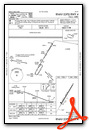
Instrument Approach Procedure (IAP) Charts
Nearby Airports with Instrument Procedures
| ID | Name | Heading / Distance | ||
|---|---|---|---|---|
 |
NY0 | Fulton County Airport | 163° | 28.5 |
|
5B2 | Saratoga County Airport | 129° | 37.5 |
|
KGFL | Floyd Bennett Memorial Airport | 099° | 40.1 |
|
KRME | Griffiss International Airport | 251° | 41.2 |
|
KSCH | Schenectady County Airport | 144° | 44.3 |
|
KALB | Albany International Airport | 143° | 52.6 |
|
4B6 | Ticonderoga Municipal Airport | 061° | 54.3 |
|
KLKP | Lake Placid Airport | 026° | 54.3 |
|
KSLK | Adirondack Regional Airport | 013° | 57.5 |
|
KVGC | Hamilton Municipal Airport | 231° | 58.7 |
|
N66 | Albert S Nader Regional Airport | 203° | 60.7 |
|
4B0 | South Albany Airport | 150° | 61.4 |
Airport Images
Do you have a recent image of this airport? Upload it here!


