Login
Register


4B6
Ticonderoga Municipal Airport
Official FAA Data Effective 2025-12-25 0901Z
Chart Supplement

VFR Chart of 4B6
Sectional Charts at SkyVector.com
IFR Chart of 4B6
Enroute Charts at SkyVector.com
Location Information for 4B6
Coordinates: N43°52.64' / W73°24.79'Located 02 miles NE of Ticonderoga, New York on 60 acres of land. View all Airports in New York.
Surveyed Elevation is 273 feet MSL.
Operations Data
|
|
Airport Communications
| CTAF: | 122.800 |
|---|---|
| UNICOM: | 122.800 |
| AWOS-3 at 6B0 (15.3 NE): | 118.575 802-388-0255 |
| AWOS-AV at VT88 (20.1 NE): | |
| AWOS-3PT at RUT (28.9 SE): | 118.375 802-747-3044 |
- APCH/DEP SVC PRVDD BY BOSTON ARTCC (ZBW) ON FREQS 135.7/282.2 (MONTPELIER RCAG).
Nearby Navigation Aids
|
| ||||||||||||||||||||||||||||||||||||||||||||||||||||||||||||


Runway 02/20
| Dimensions: | 4041 x 60 feet / 1232 x 18 meters | |
|---|---|---|
| Surface: | Asphalt in Excellent Condition | |
| Edge Lighting: | Medium Intensity RWY 02; 2 THR LGTS OTS INDEFLY. | |
| Runway 02 | Runway 20 | |
| Coordinates: | N43°52.30' / W73°24.81' | N43°52.97' / W73°24.77' |
| Elevation: | 273.6 | 264.9 |
| Traffic Pattern: | Right | |
| Runway Heading: | 2° True | 182° True |
| Markings: | Non-Precision Instrument in good condition. | Non-Precision Instrument in good condition. |
| Glide Slope Indicator | P2L (3.00° Glide Path Angle) | P2L (3.00° Glide Path Angle) |
| REIL: | Yes | Yes |
| Obstacles: | 10 ft Fence 200 ft from runway, 216 ft left of center CTLNG OBSTN EXCEEDS A 45 DEG SLP. 10 FT FENCE 0-200 FT FM RWY 216 FT LEFT. |
30 ft Trees 200 ft from runway, 116 ft left of center 30 FT TREES, 0-200 FT FM RWY, 116 FT LEFT. |
Services Available
| Fuel: | 100LL (blue) |
|---|---|
| Transient Storage: | Hangars,Tiedowns |
| Airframe Repair: | NOT AVAILABLE |
| Engine Repair: | NOT AVAILABLE |
| Bottled Oxygen: | NOT AVAILABLE |
| Bulk Oxygen: | NOT AVAILABLE |
Ownership Information
| Ownership: | Publicly owned | |
|---|---|---|
| Owner: | TOWN OF TICONDEROGA | |
| 132 MONTCALM ST | ||
| TICONDEROGA, NY 12883 | ||
| 518-585-6265 | ||
| Manager: | MARK A. WRIGHT | |
| 132 MONTCALM ST | ||
| TICONDEROGA, NY 12883 | ||
| 518-585-6265 | ||
Other Remarks
- ARPT FEES - HNGR, TIE DOWN; LDG FOR PART 135, JET/TURBINE.
- RWY 02; 50 FT TREES 1150 FT FM RWY END 50 FT LEFT.
- WINTER OPS DECEMBER - MARCH CALL FOR RWY CONDITIONS.
- WILDLIFE ON & INVOF ARPT.
- FOR CD CTC BOSTON ARTCC AT 603-879-6859.
- 0LL 100 LL SELF SVC CREDIT CARD.
- ACTVT REIL RWY 02 & 20; PAPI RWY 02 & 20; MIRL RWY 02/20 - CTAF.
Weather Minimums
Instrument Approach Procedure (IAP) Charts
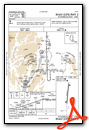
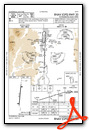
Nearby Airports with Instrument Procedures
| ID | Name | Heading / Distance | ||
|---|---|---|---|---|
 |
KRUT | Rutland/Southern Vermont Regional Airport | 135° | 29.0 |
|
KLKP | Lake Placid Airport | 314° | 33.2 |
|
KGFL | Floyd Bennett Memorial Airport | 195° | 33.3 |
|
KBTV | Patrick Leahy Burlington International Airport | 017° | 37.4 |
|
KMPV | Edward F Knapp State Airport | 061° | 41.7 |
|
KSLK | Adirondack Regional Airport | 311° | 45.9 |
|
KPBG | Plattsburgh International Airport | 357° | 46.5 |
|
KLEB | Lebanon Municipal Airport | 106° | 50.5 |
|
KVSF | Hartness State (Springfield) Airport | 129° | 50.5 |
|
KMVL | Morrisville-Stowe State Airport | 040° | 52.4 |
|
5B2 | Saratoga County Airport | 201° | 53.3 |
|
K09 | Piseco Airport | 242° | 54.3 |
Airport Images

By: TOWNOFTI


Comments
FUEL IS NOW AVAILABLE 100LL
The Town of Ticondeorga Municipal Airport now has 100LL available.