Login
Register


SCH
Schenectady County Airport
Official FAA Data Effective 2026-02-19 0901Z
Chart Supplement

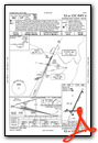
KSCH Airport Diagram

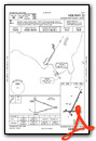
VFR Chart of KSCH
Sectional Charts at SkyVector.com
IFR Chart of KSCH
Enroute Charts at SkyVector.com
Location Information for KSCH
Coordinates: N42°51.16' / W73°55.77'Located 03 miles N of Schenectady, New York on 680 acres of land. View all Airports in New York.
Surveyed Elevation is 377 feet MSL.
Operations Data
|
|
Airport Communications
| AWOS-3: | 119.275 Tel. 518-399-6586 |
|---|---|
| SCHENECTADY TOWER: | 121.3 257.8R 291.6R 307.2R 321.1 343.7R 352.0R 378.8R |
| SCHENECTADY GROUND: | 121.9 |
| ALBANY APPROACH: | 132.825 263.075 |
| ALBANY DEPARTURE: | 132.825 263.075 |
| ANG OPS: | 340.8 |
| CTAF: | 121.300 |
| UNICOM: | 122.950 |
| EMERG: | 121.5 243.0 |
| D-ATIS at ALB (8.4 SE): | 120.45 |
| ASOS at ALB (8.4 SE): | 120.45 518-218-6284 |
| AWOS-3 at 5B2 (12.1 N): | 132.025 518-884-9289 |
Nearby Navigation Aids
|
| ||||||||||||||||||||||||||||||||||||||||||||||||||||||||||||


Runway 04/22
| Dimensions: | 7001 x 150 feet / 2134 x 46 meters | |
|---|---|---|
| Surface: | Asphalt / Grooved in Excellent Condition | |
| Weight Limits: | 62 /R/B/W/T, S-95, D-175, ST-348, DT-850 | |
| Edge Lighting: | High Intensity | |
| Runway 04 | Runway 22 | |
| Coordinates: | N42°50.81' / W73°56.03' | N42°51.85' / W73°55.34' |
| Elevation: | 318.4 | 377.9 |
| Traffic Pattern: | Left | Left |
| Runway Heading: | 26° True | 206° True |
| Markings: | Precision Instrument in good condition. | Non-Precision Instrument in good condition. |
| Glide Slope Indicator | P4L (3.00° Glide Path Angle) | P4L (3.00° Glide Path Angle) |
| Approach Lights: | MALSR 1,400 Foot Medium-intensity Approach Lighting System with runway alignment indicator lights. | |
| Obstacles: | 48 ft Trees 1086 ft from runway, 533 ft right of center | 22 ft Ground 200 ft from runway, 500 ft right of center RWY 22 +22FT RISING TERRAIN, 500 FT RT, 0 - 200 FT FM RWY. |
Runway 10/28
| Dimensions: | 4850 x 150 feet / 1478 x 46 meters | |
|---|---|---|
| Surface: | Asphalt / Grooved in Good Condition | |
| Weight Limits: | 48 /F/B/Y/T, S-55, D-134, ST-218, DT-541 | |
| Edge Lighting: | Medium Intensity | |
| Runway 10 | Runway 28 | |
| Coordinates: | N42°50.91' / W73°56.44' | N42°50.93' / W73°55.36' |
| Elevation: | 324.8 | 319.9 |
| Traffic Pattern: | Left | Left |
| Runway Heading: | 88° True | 268° True |
| Displaced Threshold: | 200 Feet | |
| Markings: | Non-Precision Instrument in good condition. | Non-Precision Instrument in good condition. |
| Glide Slope Indicator | P2L (4.00° Glide Path Angle) | P2L (3.00° Glide Path Angle) |
| REIL: | Yes | |
| Obstacles: | 32 ft Pole 520 ft from runway, 241 ft left of center RWY 10 CLNC SLOPE 14:1 TO DTHR DUE TO 87 FT TREE, 1223 FT FM DTHR, 190 FT RT. |
19 ft Trees 200 ft from runway, 230 ft right of center RWY 28 +10 FT ROAD, 150 FT - 200 FT FM RWY, 220 FT RT. |
Services Available
| Fuel: | 100LL (blue), Jet-A |
|---|---|
| Transient Storage: | Hangars,Tiedowns |
| Airframe Repair: | MINOR |
| Engine Repair: | MAJOR |
| Bottled Oxygen: | NONE |
| Bulk Oxygen: | LOW |
| Other Services: | AIR FREIGHT SERVICES,AIR AMBULANCE SERVICES,AVIONICS,CARGO HANDLING SERVICES,CHARTER SERVICE,PILOT INSTRUCTION,AIRCRAFT RENTAL,AIRCRAFT SALES,ANNUAL SURVEYING |
Ownership Information
| Ownership: | Publicly owned | |
|---|---|---|
| Owner: | SCHENECTADY COUNTY | |
| COUNTY OFFICE BLDG | ||
| SCHENECTADY, NY 12305-2114 | ||
| 518-356-5344 | ||
| Manager: | SCOTT BARBER | |
| 21 TOWER ROAD | ||
| SCOTIA, NY 12302-3487 | ||
| (518) 399-0111 | ||
Other Remarks
- LANDING FEE FOR INTINRNT MULTI-ENGINE ACFT REQUESTING TWR SVC 0330Z-1230Z.
- MILITARY: ANG APRON: ORANGE DASHED WINGTIP CLNC LINES BOTH SIDES OF YELLOW CENTER TAXILINE. DASHED WINGTIP LINES PROVIDE POSITIVE, CLEARLY IDENTIFIABLE OBST CLNC FOR TAXIING ACFT. ANY OBJECT PARKED ON BACK SIDE OF LINES PROVIDE NO WINGTIP CLNC ISSUE.
- NO ULTRA-LIGHT OPERATONS IN CLASS D AIRSPACE WITHOUT APPROV FM ATCT.
- FLT NOTIFICATION SVC (ADCUS) AVBL.
- FUEL: A++ (MIL).
- FOR CD CTC ALBANY APCH AT 518-862-2299.
- MILITARY: ANG: OPR 1030-2000Z++ MON-FRI, CLSD WKND AND FED HOL. SCHENECTADY COUNTY AIRPORT FONE NR (518)399-0377. COMSEC STORAGE AVBL FOR TRAN CREWS.
- MILITARY: CSTMS/AGG/IMG: 1300-2100Z++ MON-FRI, FONE PRIOR 2000Z++ PRECEDING WKD, C518-431-0200, C800-973-2867.
- NO UPDATED FIELD OR BRAKING ACTION REPORTS AVBL BTN 0330Z-1230Z.
- 60 FT DROPOFF 150 FT FM RY 28 END.
- NOISE ABATEMENT PROC IN EFFECT FOR LRGE ACFT REMAINING IN PATTERN CTC AIRFIELD MANAGER FOR DETAILS..
- BIRDS ON & INVOF ARPT.
- MILITARY C130 PATTERN OPERATIONS CONDUCTED DAILY.
- MILITARY: ANG: PPR BASE OPS DURG DUTY HR DSN 344-2621, C518-344-2621; OT COMD POST DSN 344-2420, C518-344-2420.
- MILITARY: CAUTION: BASH PHASE II PERIOD (15 MAR-15 MAY) AND (1 JUL-15 NOV). BIRD WATCH COND (BWC) SVR: TKOFF, LDG & LCL TRNG PROH UNLESS MSN ESTNL; BWC MDT: MULT APCH PROH, DEP & FULL-STOP ALLOWED IF RTE AVOIDS BIRD ACT; CTC ANG AFLD OPS (CALL-SIGN "SKIER OPS") FOR CURRENT BWC.
- WHEN ATCT CLSD, ACTVT MALSR RWY 04; PAPI RWY 04, 10, 22 & 28; HIRL RWY 04/22; MIRL RWY 10/28 - CTAF.
- USE 122.95 FOR SVC FM FBO
Weather Minimums


Instrument Approach Procedure (IAP) Charts


Nearby Airports with Instrument Procedures
| ID | Name | Heading / Distance | ||
|---|---|---|---|---|
 |
KALB | Albany International Airport | 137° | 8.4 |
|
5B2 | Saratoga County Airport | 014° | 12.2 |
|
4B0 | South Albany Airport | 166° | 18.0 |
|
NY0 | Fulton County Airport | 296° | 19.7 |
|
KDDH | William H Morse State Airport | 085° | 30.2 |
|
KGFL | Floyd Bennett Memorial Airport | 025° | 32.5 |
|
KAQW | Harriman-and-West Airport | 105° | 34.8 |
|
1B1 | Columbia County Airport | 163° | 35.0 |
|
KPSF | Pittsfield Municipal Airport | 131° | 38.1 |
|
K09 | Piseco Airport | 324° | 44.3 |
|
KGBR | Great Barrington Airport | 149° | 46.4 |
|
20N | Kingston-Ulster Airport | 181° | 52.1 |
Airport Images

By: 2flaps


