Login
Register


CFD
Coulter Field Airport
Official FAA Data Effective 2026-01-22 0901Z
Chart Supplement

VFR Chart of KCFD
Sectional Charts at SkyVector.com
IFR Chart of KCFD
Enroute Charts at SkyVector.com
Location Information for KCFD
Coordinates: N30°42.94' / W96°19.88'Located 03 miles NE of Bryan, Texas on 256 acres of land. View all Airports in Texas.
Surveyed Elevation is 366 feet MSL.
Operations Data
|
|
Airport Communications
| AWOS-3PT: | 125.975 Tel. 979-778-2544 |
|---|---|
| HOUSTON APPROACH: | 134.3 360.85 |
| HOUSTON DEPARTURE: | 134.3 360.85 |
| UNICOM: | 123.000 |
| CTAF: | 123.000 |
| ASOS at CLL (7.8 S): | 979-846-1708 |
| ATIS at CLL (7.8 S): | 126.85 |
| AWOS-3 at LHB (17.7 NW): | 118.675 979-280-5596 |
Nearby Navigation Aids
|
| ||||||||||||||||||||||||||||||||||||||||||||||||||||||||||||


Runway 15/33
| Dimensions: | 4000 x 75 feet / 1219 x 23 meters | |
|---|---|---|
| Surface: | Asphalt in Fair Condition | |
| Edge Lighting: | Medium Intensity | |
| Runway 15 | Runway 33 | |
| Coordinates: | N30°43.23' / W96°20.06' | N30°42.65' / W96°19.70' |
| Elevation: | 357.2 | 366.7 |
| Runway Heading: | 152° True | 332° True |
| Markings: | Non-Precision Instrument in fair condition. | Non-Precision Instrument in fair condition. |
| Glide Slope Indicator | P2L (3.50° Glide Path Angle) | P2L (3.50° Glide Path Angle) |
| REIL: | Yes | Yes |
| Obstacles: | 30 ft Trees 480 ft from runway, 280 ft left of center CONTROLLING OBSTRUCTION EXCEEDS A 45 DEGREE SLOPE |
10 ft Brush 201 ft from runway, 199 ft right of center |
Services Available
| Fuel: | 100LL (blue), Jet-A, Jet A+ |
|---|---|
| Transient Storage: | Tiedowns |
| Airframe Repair: | MAJOR |
| Engine Repair: | MAJOR |
| Bottled Oxygen: | NOT AVAILABLE |
| Bulk Oxygen: | NONE |
Ownership Information
| Ownership: | Publicly owned | |
|---|---|---|
| Owner: | CITY OF BRYAN | |
| P. O. BOX 1000 | ||
| BRYAN, TX 77803 | ||
| 979-209-5233 | ||
| Manager: | BRANDON REID | |
| 6120 SH 21E | ||
| BRYAN, TX 77808 | ||
| 979-209-5233 | ||
Other Remarks
- THIS AIRPORT HAS BEEN SURVEYED BY THE NATIONAL GEODETIC SURVEY.
- DEER ON & INVOF ARPT.
- UNLGTD HNGRS 450 FT SW AER 15.
- FOR CD CTC HOUSTON APCH AT 281-443-5844 TO CNL IFR CALL 281-443-5888.
- DUSK-DAWN. MIRL RWY 15/33 PRESET LOW INTST; TO INCR INTST - CTAF.
Weather Minimums

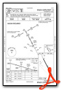
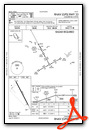
Instrument Approach Procedure (IAP) Charts
Nearby Airports with Instrument Procedures
| ID | Name | Heading / Distance | ||
|---|---|---|---|---|
 |
KCLL | Easterwood Field Airport | 191° | 7.8 |
|
KLHB | Hearne Municipal Airport | 301° | 17.7 |
|
KRWV | Caldwell Municipal Airport | 238° | 22.7 |
|
51R | Madisonville Municipal Airport | 058° | 22.9 |
|
60R | Navasota Municipal Airport | 151° | 23.7 |
|
11R | Brenham Municipal Airport | 184° | 29.8 |
|
KUTS | Huntsville Municipal Airport | 087° | 38.5 |
|
T15 | Marlin Airport | 324° | 46.0 |
|
KGYB | Giddings-Lee County Airport | 225° | 46.9 |
|
KCXO | Conroe/North Houston Regional Airport | 114° | 52.2 |
|
KDWH | David Wayne Hooks Memorial Airport | 133° | 56.3 |
|
KLXY | Mexia-Limestone County Airport | 350° | 56.2 |
Airport Images
Do you have a recent image of this airport? Upload it here!


