Login
Register


HRL
Valley International Airport
Official FAA Data Effective 2026-02-19 0901Z
Chart Supplement

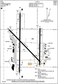
KHRL Airport Diagram
VFR Chart of KHRL
Sectional Charts at SkyVector.com
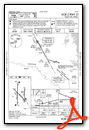
IFR Chart of KHRL
Enroute Charts at SkyVector.com
Location Information for KHRL
Coordinates: N26°13.59' / W97°39.32'Located 03 miles NE of Harlingen, Texas on 2508 acres of land. View all Airports in Texas.
Surveyed Elevation is 36 feet MSL.
Operations Data
|
|
Airport Communications
| ATIS: | 124.85 |
|---|---|
| ASOS: | 124.85 Tel. 956-428-7297 |
| HARLINGEN TOWER: | 119.3 317.6 |
| HARLINGEN GROUND: | 121.7 |
| VALLEY APPROACH: | 120.7 279.5 |
| VALLEY DEPARTURE: | 120.7 279.5 |
| UNICOM: | 122.950 |
| CTAF: | 119.300 |
| CLASS C: | 120.7 279.5 |
| ASOS at PIL (17.1 E): | 118.525 956-233-1954 |
| AWOS-3PT at TXW (17.5 W): | 118.575 956-447-0414 |
| ASOS at BRO (22.6 SE): | 128.55 956-299-5871 |
Nearby Navigation Aids
|
| ||||||||||||||||||||||||||||||||||||||||||||||||


Runway 18R/36L
| Dimensions: | 9400 x 150 feet / 2865 x 46 meters | |
|---|---|---|
| Surface: | Asphalt / Grooved in Good Condition | |
| Weight Limits: | S-160, D-200, ST-350, DT-700
PCR VALUE: 380/F/D/X/T
| |
| Edge Lighting: | High Intensity | |
| Runway 18R | Runway 36L | |
| Coordinates: | N26°14.42' / W97°39.51' | N26°12.87' / W97°39.53' |
| Elevation: | 34.0 | 35.5 |
| Traffic Pattern: | Right | Left |
| Runway Heading: | 181° True | 1° True |
| Declared Distances: | TORA:9400 TODA:9400 ASDA:9400 LDA:9400 | TORA:9400 TODA:9400 ASDA:9400 LDA:9400 |
| Markings: | Precision Instrument in good condition. | Precision Instrument in good condition. |
| Glide Slope Indicator | P4L (3.00° Glide Path Angle) | P4R (3.00° Glide Path Angle) |
| RVR Equipment | Touchdown Midfield Rollout | Touchdown Midfield Rollout |
| Approach Lights: | MALSR 1,400 Foot Medium-intensity Approach Lighting System with runway alignment indicator lights. | MALSR 1,400 Foot Medium-intensity Approach Lighting System with runway alignment indicator lights. |
Runway 13/31
| Dimensions: | 7257 x 150 feet / 2212 x 46 meters | |
|---|---|---|
| Surface: | Asphalt / Grooved in Good Condition | |
| Weight Limits: | S-160, D-200, ST-350, DT-700
PCR VALUE: 310/F/D/X/T
| |
| Edge Lighting: | High Intensity | |
| Runway 13 | Runway 31 | |
| Coordinates: | N26°13.99' / W97°39.84' | N26°13.13' / W97°38.91' |
| Elevation: | 34.4 | 35.7 |
| Traffic Pattern: | Left | Left |
| Runway Heading: | 136° True | 316° True |
| Declared Distances: | TORA:7257 TODA:7257 ASDA:7257 LDA:7257 | TORA:7257 TODA:7257 ASDA:7257 LDA:7257 |
| Markings: | Precision Instrument in good condition. | Precision Instrument in good condition. |
| Glide Slope Indicator | P4L (3.00° Glide Path Angle) | P4L (3.00° Glide Path Angle) |
| Approach Lights: | MALSR 1,400 Foot Medium-intensity Approach Lighting System with runway alignment indicator lights. | |
| REIL: | Yes | |
Runway 18L/36R
| Dimensions: | 5950 x 150 feet / 1814 x 46 meters | |
|---|---|---|
| Surface: | Asphalt in Good Condition | |
| Weight Limits: | S-160, D-200, ST-350
PCR VALUE: 210/R/B/W/T
| |
| Edge Lighting: | Medium Intensity | |
| Runway 18L | Runway 36R | |
| Coordinates: | N26°14.04' / W97°38.92' | N26°13.06' / W97°38.93' |
| Elevation: | 33.7 | 35.0 |
| Traffic Pattern: | Left | Right |
| Runway Heading: | 181° True | 1° True |
| Displaced Threshold: | 190 Feet | |
| Declared Distances: | TORA:5949 TODA:5949 ASDA:5949 LDA:5949 | TORA:5949 TODA:5949 ASDA:5949 LDA:5759 |
| Markings: | Precision Instrument in good condition. | Precision Instrument in good condition. |
| Glide Slope Indicator | P4L (3.00° Glide Path Angle) UNUSBL BYD 7 DEGS RIGHT OF CNTRLN. | |
| REIL: | Yes | |
Services Available
| Fuel: | 100LL (blue), Jet-A |
|---|---|
| Transient Storage: | Hangars,Tiedowns |
| Airframe Repair: | MAJOR |
| Engine Repair: | MAJOR |
| Bottled Oxygen: | HIGH |
| Bulk Oxygen: | NOT AVAILABLE |
| Other Services: | AIR FREIGHT SERVICES,AVIONICS,CARGO HANDLING SERVICES,CHARTER SERVICE,PILOT INSTRUCTION,AIRCRAFT RENTAL,AIRCRAFT SALES |
Ownership Information
| Ownership: | Publicly owned | |
|---|---|---|
| Owner: | CITY OF HARLINGEN | |
| PO BOX 2207 | ||
| HARLINGEN, TX 78550-2207 | ||
| (956) 430-8605 | ||
| Manager: | MARV ESTERLY | |
| AIRPORT TERMINAL BUILDING,, 3002 HE, 3200 HERITAGE WAY | ||
| HARLINGEN, TX 78550 | ||
| 956-430-8605 | ||
Other Remarks
- MIGRATORY BIRDS ON & INVOF ARPT.
- WHEN ATCT CLSD REQ ARFF THRU CORPUS APPROACH OR FLT SVC.
- FOR CD WHEN ATCT IS CLSD CTC CRP APCH AT 361-299-4230.
- DUSK-DAWN. WHEN ATCT CLSD ACTVT MALSR RWY 18R, RWY 31, RWY 36L - CTAF.
Weather Minimums


Instrument Approach Procedure (IAP) Charts
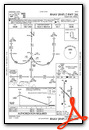
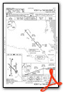
- ILS OR LOC RWY 18R

- ILS OR LOC RWY 36L
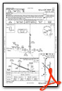
- ILS RWY 18R (SA CAT I - II)
- ILS RWY 36L (SA CAT I - II)

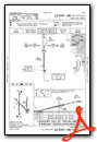
- RNAV (RNP) Z RWY 13
- RNAV (RNP) Z RWY 18R

- RNAV (RNP) Z RWY 31

- RNAV (RNP) Z RWY 36L
- RNAV (GPS) RWY 18L
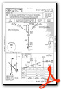
- RNAV (GPS) RWY 36R

- RNAV (GPS) Y RWY 13

- RNAV (GPS) Y RWY 18R

- RNAV (GPS) Y RWY 31

- RNAV (GPS) Y RWY 36L

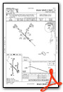
- VOR RWY 18L
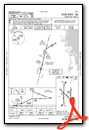
- VOR RWY 18R

- VOR RWY 36L

- VOR Y OR TACAN RWY 31
- VOR Z RWY 31
Nearby Airports with Instrument Procedures
| ID | Name | Heading / Distance | ||
|---|---|---|---|---|
 |
KPIL | Cameron County Airport | 102° | 17.1 |
|
KTXW | Mid Valley Airport | 260° | 17.4 |
|
KBRO | Brownsville/South Padre Island International Airport | 147° | 22.8 |
|
KEBG | South Texas International At Edinburg Airport | 297° | 28.3 |
|
KMFE | Mc Allen International Airport | 264° | 31.6 |
|
KBKS | Brooks County Airport | 336° | 63.7 |
|
KNQI | Kingsville NAS Airport | 353° | 76.9 |
|
KIKG | Kleberg County Airport | 345° | 81.8 |
|
KHBV | Jim Hogg County Airport | 319° | 88.8 |
|
KNGP | Corpus Christi NAS (Truax Field) Airport | 012° | 89.9 |
|
KALI | Alice International Airport | 347° | 92.8 |
|
KCRP | Corpus Christi International Airport | 005° | 92.8 |
Fuel Providers

Airport Images
Do you have a recent image of this airport? Upload it here!


