Login
Register


IKG
Kleberg County Airport
Official FAA Data Effective 2026-01-22 0901Z
Chart Supplement

VFR Chart of KIKG
Sectional Charts at SkyVector.com
IFR Chart of KIKG
Enroute Charts at SkyVector.com
Location Information for KIKG
Coordinates: N27°33.05' / W98°1.86'Located 09 miles W of Kingsville, Texas on 295 acres of land. View all Airports in Texas.
Surveyed Elevation is 130 feet MSL.
Operations Data
|
|
Airport Communications
| AWOS-3P: | 119.075 Tel. 361-592-9152 |
|---|---|
| KINGSVILLE APPROACH: | 119.9 290.45 |
| KINGSVILLE DEPARTURE: | 119.9 305.2 |
| CTAF: | 122.700 |
| UNICOM: | 122.700 |
| ASOS at ALI (11.4 N): | 119.225 361-668-0069 |
| ATIS at NQI (12.2 E): | 282.25 |
| ATIS at NOG (20.8 N): | 254.35 |
- APCH/DEP SVC PRVDD BY HOUSTON ARTCC (ZHU) ON FREQS 128.15/350.3 (SARITA RCAG) WHEN KINGSVILLE APCH CLSD.
Nearby Navigation Aids
|
| ||||||||||||||||||||||||||||||||||||


Runway 13/31
| Dimensions: | 6000 x 75 feet / 1829 x 23 meters | |
|---|---|---|
| Surface: | Asphalt in Good Condition | |
| Weight Limits: | S-35, D-47, ST-70 | |
| Edge Lighting: | Medium Intensity | |
| Runway 13 | Runway 31 | |
| Coordinates: | N27°33.43' / W98°2.21' | N27°32.67' / W98°1.50' |
| Elevation: | 130.1 | 124.5 |
| Traffic Pattern: | Left | Left |
| Runway Heading: | 140° True | 320° True |
| Markings: | Non-Precision Instrument in poor condition. | Non-Precision Instrument in poor condition. |
| Glide Slope Indicator | P4L (3.00° Glide Path Angle) | P4L (3.00° Glide Path Angle) |
| REIL: | Yes | Yes |
| Obstacles: | 20 ft Trees 201 ft from runway, 270 ft left of center 20 FT TREES 0-199 FT FM THR 270 FT L. |
30 ft Tree 1460 ft from runway, 540 ft left of center |
Services Available
| Fuel: | 100LL (blue), Jet A+ |
|---|---|
| Transient Storage: | Hangars,Tiedowns |
| Airframe Repair: | MAJOR |
| Engine Repair: | MAJOR |
| Bottled Oxygen: | HIGH |
| Bulk Oxygen: | NONE |
Ownership Information
| Ownership: | Publicly owned | |
|---|---|---|
| Owner: | KLEBERG COUNTY | |
| PO BOX 752 | ||
| KINGSVILLE, TX 78364 | ||
| 361-595-8585 | ||
| Manager: | MIKE MUZYCZYN, FBO | |
| PO BOX 53 | ||
| KINGSVILLE, TX 78364 | ||
| 361-592-1225 | ||
Other Remarks
- THIS AIRPORT HAS BEEN SURVEYED BY THE NATIONAL GEODETIC SURVEY.
- BIRDS ON & INVOF ARPT.
- FOR CD CTC HOUSTON ARTCC AT 281-230-5622.
- RWY MKGS FADED.
- RWY MKGS FADED.
- SS-SR MIRL RWY 13/31 PRESET LOW INTST; TO INCR INTST & ACTVT REIL RWYS 13 & 31 - CTAF.
Weather Minimums
Instrument Approach Procedure (IAP) Charts
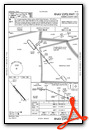
Nearby Airports with Instrument Procedures
| ID | Name | Heading / Distance | ||
|---|---|---|---|---|
 |
KALI | Alice International Airport | 001° | 11.4 |
|
KNQI | Kingsville NAS Airport | 103° | 12.2 |
|
KNOG | Orange Grove Nalf Airport | 358° | 20.7 |
|
KBKS | Brooks County Airport | 193° | 21.2 |
|
KRBO | Nueces County Airport | 053° | 22.7 |
|
KCRP | Corpus Christi International Airport | 064° | 31.1 |
|
T69 | Sinton Airport | 041° | 39.1 |
|
KHBV | Jim Hogg County Airport | 252° | 39.6 |
|
KNGP | Corpus Christi NAS (Truax Field) Airport | 077° | 40.4 |
|
KTFP | Ingleside Regional Airport | 063° | 48.7 |
|
8T6 | Live Oak County Airport | 354° | 48.8 |
|
KBEA | Beeville Municipal Airport | 014° | 50.3 |
Airport Images
Do you have a recent image of this airport? Upload it here!


