Login
Register


BKS
Brooks County Airport
Official FAA Data Effective 2026-02-19 0901Z
Chart Supplement

VFR Chart of KBKS
Sectional Charts at SkyVector.com
IFR Chart of KBKS
Enroute Charts at SkyVector.com
Location Information for KBKS
Coordinates: N27°12.36' / W98°7.26'Located 02 miles SE of Falfurrias, Texas on 169 acres of land. View all Airports in Texas.
Surveyed Elevation is 111 feet MSL.
Operations Data
|
|
Airport Communications
| AWOS-3PT: | 118.125 Tel. 361-325-4055 |
|---|---|
| KINGSVILLE APPROACH: | 119.9 290.45 |
| KINGSVILLE DEPARTURE: | 119.9 305.2 |
| CTAF: | 122.800 |
| UNICOM: | 122.800 |
| AWOS-3P at IKG (21.3 N): | 119.075 361-592-9152 |
| ATIS at NQI (24.5 NE): | 282.25 |
| AWOS-3T at U38 (30.2 SW): | 135.975 |
- APCH/DEP SVC PRVDD BY HOUSTON ARTCC (ZHU) ON FREQS 128.15/350.3 (SARITA RCAG) WHEN KINGSVILLE APCH CLSD.
Nearby Navigation Aids
|
| ||||||||||||||||||||||||||||||||||||||||||


Runway 17/35
| Dimensions: | 6006 x 75 feet / 1831 x 23 meters | |
|---|---|---|
| Surface: | Asphalt in Good Condition | |
| Weight Limits: | S-52, D-80 | |
| Edge Lighting: | Medium Intensity | |
| Runway 17 | Runway 35 | |
| Coordinates: | N27°12.88' / W98°7.21' | N27°11.89' / W98°7.21' |
| Elevation: | 111.4 | 110.7 |
| Traffic Pattern: | Left | Left |
| Runway Heading: | 180° True | 360° True |
| Markings: | Non-Precision Instrument in fair condition. | Non-Precision Instrument in fair condition. |
| Glide Slope Indicator | P4L (3.00° Glide Path Angle) | P4L (3.00° Glide Path Angle) |
| REIL: | Yes | |
| Obstacles: | 36 ft Tree 1046 ft from runway, 415 ft right of center | |
Runway 14/32
| Dimensions: | 3018 x 60 feet / 920 x 18 meters | |
|---|---|---|
| Surface: | Asphalt in Excellent Condition | |
| Weight Limits: | S-18 | |
| Runway 14 | Runway 32 | |
| Coordinates: | N27°12.54' / W98°7.51' | N27°12.11' / W98°7.23' |
| Elevation: | 110.8 | 110.8 |
| Runway Heading: | 149° True | 329° True |
| Markings: | Non-Precision Instrument in fair condition. | Non-Precision Instrument in fair condition. |
| Obstacles: | 25 ft Trees 450 ft from runway, 100 ft left of center | |
Services Available
| Fuel: | 100LL (blue), Jet-A |
|---|---|
| Transient Storage: | Tiedowns |
| Airframe Repair: | NONE |
| Engine Repair: | NONE |
| Bottled Oxygen: | NONE |
| Bulk Oxygen: | NONE |
Ownership Information
| Ownership: | Publicly owned | |
|---|---|---|
| Owner: | BROOKS COUNTY | |
| CO COMMISSIONERS COURT | ||
| FALFURRIAS, TX 78355 | ||
| 361-325-5604 | ||
| Manager: | BOND COSBY | |
| PO BOX 556 | ||
| FALFURRIAS, TX 78355 | ||
| 361-325-2909 | 361-850-3430 OR FROM NOV-FEB ON CALL 24/7 | |
Other Remarks
- 9 FT FENCE LCTD APRX 900 FT NORTH OF RWY 17.
- FOR CD CTC HOUSTON ARTCC AT 281-230-5622.
- MIRL RWY 17/35 PRESET LOW INTST. TO INCR INTST & ACTVT REIL RWY 17; PAPI RWYS 17 & 35 - CTAF.
Weather Minimums


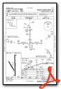
Instrument Approach Procedure (IAP) Charts

Nearby Airports with Instrument Procedures
| ID | Name | Heading / Distance | ||
|---|---|---|---|---|
 |
KIKG | Kleberg County Airport | 013° | 21.2 |
|
KNQI | Kingsville NAS Airport | 043° | 24.5 |
|
KALI | Alice International Airport | 008° | 32.4 |
|
KHBV | Jim Hogg County Airport | 284° | 34.0 |
|
KRBO | Nueces County Airport | 033° | 41.2 |
|
KNOG | Orange Grove Nalf Airport | 005° | 41.5 |
|
KEBG | South Texas International At Edinburg Airport | 180° | 45.7 |
|
KCRP | Corpus Christi International Airport | 044° | 47.3 |
|
KNGP | Corpus Christi NAS (Truax Field) Airport | 056° | 53.0 |
|
T69 | Sinton Airport | 031° | 58.6 |
|
KMFE | Mc Allen International Airport | 185° | 62.0 |
|
KTXW | Mid Valley Airport | 172° | 62.0 |
Airport Images
Do you have a recent image of this airport? Upload it here!


