Login
Register
LGU
Logan-Cache Airport
Official FAA Data Effective 2025-12-25 0901Z
VFR Chart of KLGU
Sectional Charts at SkyVector.com
IFR Chart of KLGU
Enroute Charts at SkyVector.com
Location Information for KLGU
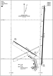
Coordinates: N41°47.51' / W111°51.10'Located 03 miles NW of Logan, Utah on 739 acres of land. View all Airports in Utah.
Estimated Elevation is 4456 feet MSL.
Operations Data
|
|
Airport Communications
| ASOS: | 135.275 Tel. 435-752-6941 |
|---|---|
| CTAF: | 122.800 |
| UNICOM: | 122.800 |
| AWOS-3 at BMC (17.1 SW): | 135.075 435-723-3852 |
| AWOS-3 at 1U7 (36.0 NE): | 118.525 208 847 0613 |
| ATIS at OGD (36.5 S): | 125.55 |
- COMMUNICATIONS PRVDD BY CEDAR CITY RADIO ON FREQ 122.2. (FRANCIS PEAK RCO)
- APCH/DEP CTL SVC PRVDD BY SALT LAKE ARTCC (ZLC) ON 127.7/354.125 (MALAD CITY RCAG).
Nearby Navigation Aids
|
| ||||||||||||||||||||||||||||||||||||
Runway 17/35
| Dimensions: | 9020 x 100 feet / 2749 x 30 meters | |
|---|---|---|
| Surface: | Asphalt in Excellent Condition | |
| Weight Limits: | S-24, D-179
PCR VALUE: 550/F/D/X/T
| |
| Edge Lighting: | High Intensity | |
| Runway 17 | Runway 35 | |
| Coordinates: | N41°48.35' / W111°50.86' | N41°46.87' / W111°50.95' |
| Elevation: | 4456.8 | 4456.4 |
| Traffic Pattern: | Left | Left |
| Runway Heading: | 183° True | 3° True |
| Declared Distances: | TORA:9020 TODA:9020 ASDA:9020 LDA:9020 | TORA:9020 TODA:9020 ASDA:9020 LDA:9020 |
| Markings: | Precision Instrument in good condition. | Precision Instrument in good condition. |
| Glide Slope Indicator | P2L (3.00° Glide Path Angle) | P2L (3.00° Glide Path Angle) |
| Approach Lights: | MALSR 1,400 Foot Medium-intensity Approach Lighting System with runway alignment indicator lights. | |
| REIL: | Yes | |
| Obstacles: | 23 ft Railroad 555 ft from runway, 560 ft left of center | |
Runway 10/28
DALGT USE ONLY. | ||
| Dimensions: | 4075 x 60 feet / 1242 x 18 meters | |
|---|---|---|
| Surface: | Asphalt in Excellent Condition | |
| Weight Limits: | S-12 | |
| Runway 10 | Runway 28 | |
| Coordinates: | N41°47.46' / W111°51.91' | N41°47.10' / W111°51.15' |
| Elevation: | 4440.1 | 4449.7 |
| Traffic Pattern: | Left | Left |
| Runway Heading: | 122° True | 302° True |
| Declared Distances: | TORA:4075 TODA:4075 | TORA:4075 TODA:4075 |
| Markings: | Basic in poor condition. | Basic in poor condition. |
| Obstacles: | 23 ft Railroad 485 ft from runway | |
Services Available
| Fuel: | 100LL (blue), Jet-A |
|---|---|
| Transient Storage: | Hangars,Tiedowns |
| Airframe Repair: | MAJOR |
| Engine Repair: | MAJOR |
| Bottled Oxygen: | NOT AVAILABLE |
| Bulk Oxygen: | HIGH/LOW |
| Other Services: | CHARTER SERVICE,PILOT INSTRUCTION,AIRCRAFT RENTAL |
Ownership Information
| Ownership: | Publicly owned | |
|---|---|---|
| Owner: | LOGAN CITY & CACHE CO | |
| 199 N. MAIN | ||
| LOGAN, UT 84321 | ||
| (435) 755-1850 | ||
| Manager: | BOB LOW | |
| 199 N. MAIN | ||
| LOGAN, UT 84321 | ||
| 435-755-1750 | ||
Other Remarks
- BIRDS ON & INVOF ARPT SPRING & SUMMER.
- COLD TEMPERATURE AIRPORT. ALTITUDE CORRECTION REQUIRED AT OR BELOW -14C.
- FLT TRNG INVOF ARPT.
- FOR CD CTC SALT LAKE ARTCC AT 801-320-2568.
- 0LL AVBL H24 WITH CREDIT CARD; AFT HR - 435-753-2221/435-752-5955.
- ACTVT MALSR RWY 17; REIL RWY 35; PAPI RWY 17 & 35; HIRL RWY 17/35 - CTAF.
Weather Minimums
Instrument Approach Procedure (IAP) Charts
Departure Procedure Obstacles (DPO) Charts
Nearby Airports with Instrument Procedures
| ID | Name | Heading / Distance | ||
|---|---|---|---|---|
 |
KBMC | Brigham City Regional Airport | 213° | 17.1 |
 |
1U7 | Bear Lake County Airport | 039° | 35.7 |
 |
KOGD | Ogden-Hinckley Airport | 191° | 36.5 |
 |
KHIF | Hill AFB Airport | 187° | 40.4 |
 |
KEVW | Evanston-Uinta County Burns Field Airport | 129° | 48.1 |
 |
KEMM | Kemmerer Municipal Airport | 087° | 58.1 |
 |
KSLC | Salt Lake City International Airport | 185° | 60.4 |
 |
KAFO | Afton Lincoln County/General Boyd L Eddins Field Airport | 036° | 68.3 |
 |
KFBR | Fort Bridger Airport | 109° | 69.3 |
 |
KSVR | South Valley Regional Airport | 185° | 70.6 |
 |
KTVY | Bolinder Field/Tooele Valley Airport | 197° | 74.2 |
 |
KPIH | Pocatello Regional Airport | 333° | 74.8 |


