Login
Register


LLR
Little River Airport
Official FAA Data Effective 2025-11-27 0901Z
Chart Supplement

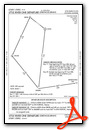
VFR Chart of KLLR
Sectional Charts at SkyVector.com
IFR Chart of KLLR
Enroute Charts at SkyVector.com
Location Information for KLLR
Coordinates: N39°15.72' / W123°45.23'Located 03 miles SE of Little River, California on 548 acres of land. View all Airports in California.
Surveyed Elevation is 573 feet MSL.
Operations Data
|
|
Airport Communications
| AWOS-3: | 121.125 Tel. 707-937-6059 |
|---|---|
| CTAF: | 122.700 |
| UNICOM: | 122.700 |
| AWOS-A at CN01 (10.4 N): | 707-961-4603 |
| ASOS at UKI (27.0 E): | 119.275 707-462-7343 |
| AWOS-3 at 1O2 (43.2 SE): | 118.35 707-262-0380 |
- APCH/DEP CTL SVC PRVDD BY OAKLAND ARTCC (ZOA) ON FREQS 132.2/350.3 (UKIAH RCAG).
Nearby Navigation Aids
|
| ||||||||||||||||||||||||||||||||||||


Runway 11/29
| Dimensions: | 5249 x 100 feet / 1600 x 30 meters | |
|---|---|---|
| Surface: | Asphalt in Good Condition | |
| Weight Limits: | S-60, D-200, ST-400 | |
| Edge Lighting: | Medium Intensity | |
| Runway 11 | Runway 29 | |
| Coordinates: | N39°15.99' / W123°45.67' | N39°15.46' / W123°44.79' |
| Elevation: | 547.6 | 573.8 |
| Traffic Pattern: | Left | Left |
| Runway Heading: | 128° True | 308° True |
| Displaced Threshold: | 200 Feet | |
| Markings: | Basic in good condition. | Basic in good condition. |
| Glide Slope Indicator | P4L (3.50° Glide Path Angle) | |
| Obstacles: | 6 ft Brush 200 ft from runway RWY 11 APCH RATIO 31:1 TO DSPLCD THR OVER +35' TREES @ 1200', 312' RIGHT FM EOR. |
45 ft Trees 1500 ft from runway |
Services Available
| Fuel: | 100LL (blue) |
|---|---|
| Transient Storage: | Tiedowns |
| Airframe Repair: | NONE |
| Engine Repair: | NONE |
| Bottled Oxygen: | NONE |
| Bulk Oxygen: | NONE |
Ownership Information
| Ownership: | Publicly owned | |
|---|---|---|
| Owner: | MENDOCINO COUNTY | |
| 340 LAKE MENDOCINO DRIVE | ||
| UKIAH, CA 95482-9432 | ||
| 707-463-4363 | ||
| Manager: | HOWARD DASHIELL | DIRECTOR OF TRANSPORTATION |
| 340 LAKE MENDOCINO DRIVE | ||
| UKIAH, CA 95482-9432 | ||
| (707) 463-4363 | ||
Other Remarks
- FOR CD CTC OAKLAND ARTCC AT 510-745-3380.
- FOR ARPT ATTENDANT CTC 707-367-1137.
- ACTVT PAPI RWY 29; MIRL RWY 11/29 - CTAF
- AUTOMATED UNICOM.
Weather Minimums

Instrument Approach Procedure (IAP) Charts
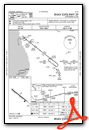
Departure Procedure Obstacles (DPO) Charts
Nearby Airports with Instrument Procedures
| ID | Name | Heading / Distance | ||
|---|---|---|---|---|
 |
O28 | Ells Field/Willits Municipal Airport | 057° | 21.1 |
|
KUKI | Ukiah Municipal Airport | 107° | 27.1 |
|
1O2 | Lampson Field Airport | 111° | 43.0 |
|
O60 | Cloverdale Municipal Airport | 129° | 46.0 |
|
KHES | Healdsburg Municipal Airport | 132° | 54.2 |
|
KSTS | Charles M Schulz/Sonoma County Airport | 135° | 63.1 |
|
KWLW | Willows/Glenn County Airport | 077° | 73.1 |
|
O37 | Haigh Field Airport | 069° | 79.6 |
|
KFOT | Rohnerville Airport | 347° | 79.4 |
|
O69 | Petaluma Municipal Airport | 137° | 80.8 |
|
O08 | Colusa County Airport | 092° | 82.2 |
|
KDVO | Gnoss Field Airport | 139° | 87.5 |
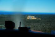
Airport Images

By: maximeguillaud
By: Alexsipilot


Comments
AWOS
SuperAWOS at: https://potomacaviation.com/weather_index.asp?airportid=KLLR