Login
Register


O08
Colusa County Airport
Official FAA Data Effective 2026-01-22 0901Z
Chart Supplement

VFR Chart of O08
Sectional Charts at SkyVector.com
IFR Chart of O08
Enroute Charts at SkyVector.com
Location Information for O08
Coordinates: N39°10.74' / W121°59.60'Located 03 miles S of Colusa, California on 81 acres of land. View all Airports in California.
Surveyed Elevation is 49 feet MSL.
Operations Data
|
|
Airport Communications
| CTAF: | 122.800 |
|---|---|
| UNICOM: | 122.800 |
| ASOS at MYV (20.3 E): | 118.475 530-742-0695 |
| ASOS at OVE (25.6 NE): | 121.425 530-533-5792 |
| ATIS at BAB (26.0 E): | 124.55 |
- APCH/DEP CTL SVC PRVDD BY OAKLAND ARTCC (ZOA) ON FREQS 132.2/350.3 (RED BLUFF RCAG).
Nearby Navigation Aids
|
| ||||||||||||||||||||||||||||||||||||


Runway 14/32
| Dimensions: | 3034 x 59 feet / 925 x 18 meters | |
|---|---|---|
| Surface: | Asphalt in Good Condition | |
| Weight Limits: | S-10 | |
| Edge Lighting: | Medium Intensity | |
| Runway 14 | Runway 32 | |
| Coordinates: | N39°10.96' / W121°59.76' | N39°10.52' / W121°59.44' |
| Elevation: | 48.8 | 46.8 |
| Traffic Pattern: | Right | |
| Runway Heading: | 151° True | 331° True |
| Markings: | Non-Precision Instrument in good condition. | Non-Precision Instrument in good condition. |
| Glide Slope Indicator | P2L (3.00° Glide Path Angle) | P2L (3.00° Glide Path Angle) |
| Obstacles: | 15 ft Road 450 ft from runway | |
Services Available
| Fuel: | 100LL (blue) |
|---|---|
| Transient Storage: | Tiedowns |
| Airframe Repair: | MAJOR |
| Engine Repair: | MAJOR |
| Bottled Oxygen: | NONE |
| Bulk Oxygen: | NONE |
| Other Services: | CROP DUSTING SERVICES,CHARTER SERVICE,PILOT INSTRUCTION,AIRCRAFT RENTAL |
Ownership Information
| Ownership: | Publicly owned | |
|---|---|---|
| Owner: | COUNTY OF COLUSA | |
| COUNTY COURTHOUSE | ||
| COLUSA, CA 95932 | ||
| 530-458-0466 | ||
| Manager: | MICHAEL AZEVEDO | COUNTY PUB WORKS DIR. ARPT MGR 530-682-2612. |
| 1215 MARKET ST, SUITE F | ||
| COLUSA, CA 95932-3246 | ||
| 530-682-2612 | ||
Other Remarks
- BE ALERT TO BLDG 120 FT AGL 1000 FT WEST.
- (E81) RWY EXIT LGTS ONLY.
- BIRDS ON AND IN VICINITY OF AIRPORT
- FOR CD CTC OAKLAND ARTCC AT 510-745-3380.
- 0LL FUEL AVBL BY CREDIT CARD 24/7
- ACTVT MIRL RWY 14/32 - CTAF.
Weather Minimums

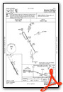
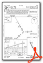
Instrument Approach Procedure (IAP) Charts

Nearby Airports with Instrument Procedures
| ID | Name | Heading / Distance | ||
|---|---|---|---|---|
 |
KMYV | Yuba County Airport | 103° | 20.4 |
|
KWLW | Willows/Glenn County Airport | 332° | 22.7 |
|
KOVE | Oroville Municipal Airport | 042° | 25.3 |
|
KBAB | Beale AFB Airport | 095° | 26.1 |
|
O41 | Watts-Woodland Airport | 169° | 30.8 |
|
O37 | Haigh Field Airport | 347° | 33.2 |
|
KLHM | Lincoln Regional/Karl Harder Field Airport | 118° | 34.1 |
|
KSMF | Sacramento International Airport | 146° | 34.6 |
|
KDWA | Yolo County Airport | 169° | 36.5 |
|
KCIC | Chico Regional Airport | 009° | 37.5 |
|
KEDU | University Airport | 165° | 40.0 |
|
KMCC | Mc Clellan Airfield Airport | 137° | 41.4 |
Airport Images

By: Catdesigns

By: Catdesigns


Comments
a/fd
What happened to the faa a/fd pages?